BEST THING TO HAPPEN TO GOLF SINCE THE CREATION OF THE 19TH HOLE
BlueBallSports' "Putt-Her"
BEST PLACE TO PLAY TENNIS
Scottsdale Athletic Club

Non-members are welcome for lessons and clinics by club pro Jarek Jabczynski, a world-ranked player and member of the Polish Davis Cup team.
And no, we don't know how many Polish tennis players it takes to win a Davis Cup match.
- 8225 E. Indian Bend, Scottsdale, 85250 Map
- 480-344-0600
- www.scottsdaleresortandathleticclub.com
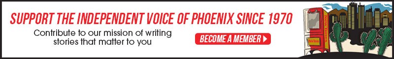
BEST PLACE TO CLIMB THE WALLS
Phoenix Rock Gym
Phoenix Rock Gym was the first indoor climbing facility in the state, and still carries the most cred with the outdoor extremists. On weeknights, once the kids have cleared out, the 15,000-square-foot mini-canyon is filled with Dief's pro bouldering buddies. But the 17-foot overhang in the spacious beginners' area is designed to bring home the thrill of the big-time climb to the lil' lowlanders. "The kids love it, 'cause when you fall, you kind of swing out, and go for a ride," Dief says. "As long as you've got a rope on, falling is fun!"
- 1353 E. University Dr., Tempe, 85281 Map
- 480-921-8322
- www.phoenixrockgym.com
BEST DAY HIKE
Lost Goldmine Trail
BEST KILLER HIKE
Reavis Ranch Trail

One of the longest, meanest and most rewarding hikes in the Superstitions begins at the Reavis Ranch Trailhead. From this trailhead, you can work yourself deep into the wilderness and onto several of the area's most scenic walks.
Twelve miles in, in Roger's Canyon, you'll reach one of the finest Salado cliff dwellings in the region. Vandals apparently aren't willing to hike 24 miles round-trip. The cliff dwellings are in pristine shape.
Obviously, this is not a hike for the weak or ill-prepared. Take all precautions necessary for a long, difficult hike in the desert. There are many switchbacks, washouts, sharp drop-offs, sharp rocks and other obstacles that make this trip not only one of the most beautiful in the area, but also the most dangerous.
- Superstition Mountains, Tonto National Forest Highway 88, Scottsdale, 85257 Map
- 480-610-3300
- www.arizonahiking.org/index.php/component/content/article/84-superstition-and-mazatzal-wilderness/194-reavis-ranch
BEST SHABBY CHIC HIKE
Papago Park
Oh, how we hate to give this away, but here's our usual route (which is, by the way, unmarked and unnamed): After parking at the landmark known as Hole-in-the-Rock, head west by northwest toward the Big Buttes on McDowell Road. After you cross Galvin Parkway and close on the Buttes, you'll strike a trail that takes you gently around them, or you can path-find your way over them, which is technically quite challenging and a heckuva lot more fun. Once past the Big Buttes, head due south toward Saddle Butte. Climb up to the saddle and then scramble down the other side. Head south by southeast across the washboard. Re-cross Galvin and head due east, where you'll soon find yourself in the Phoenix Zoo parking lot. Look to your left for the nuclear pond and follow its southern flank to another trail that borders the north side of the zoo. Your next landmark -- no, it's not a desert mirage -- is the odd-duck pyramid, situated incongruously upon a small butte, which houses the corpse of Arizona's first governor, George W.P. Hunt. From the pyramid, look north toward Hole-in-the-Rock and set your star by it.
We usually finish with a breathtaking 360-degree view of the Valley from atop the Rock, followed by a windows-down, moon-roof-up, stereo-blasting drive on Galvin, the Valley's only truly crooked street. Ah, but that's another story . . .
- 625 N. Galvin Parkway, Phoenix, 85004 Map
- 602-256-3220
- www.phoenix.gov/parks/hikepapa.html
BEST HIKE FOR THE FAMILY
South Mountain Park's Telegraph Pass Trail
- 10919 S. Central Ave., Phoenix, 85042 Map
- 602-262-7393
- www.phoenix.gov/parks/southmnt.html
BEST FALL DAY TRIP FOR THE FAMILY
Boyce Thompson Arboretum State Park

The 323-acre Arboretum, founded in the 1920s by mining magnate Colonel William Boyce Thompson, is the state's oldest and largest botanical garden. And beyond that, it's arguably the state's greatest place for a leisurely stroll.
This year, thanks to plentiful rains, the colors should be particularly beautiful. Arboretum officials estimate the peak color season will be from November 20 through December 5.
Thanksgiving weekend, the Arboretum will be hosting its annual fall color festival with music, storytellers, apple cider and numerous guided tours. It's a great event for families with guests in town for the holidays.
- 37615 Highway 60, Superior, 85273 Map
- 520-689-2811
- www.wildlifeviewingareas.com/wv-app/ParkDetail.aspx?ParkID=102
BEST SPRING DAY TRIP FOR THE FAMILY
Picacho Peak State Park

One of the most spectacular shows of color, and one of the most easily accessed, is Picacho Peak State Park 60 miles south of Phoenix, which, if you didn't know, is that giant solitary mountain you nearly run into on your way to Tucson.
During peak wildflower season, drivers along I-10 have been known to stop along the freeway to gaze at the outbreak of Mexican gold poppies along the mount's eastern slope.
This isn't smart. Better to come into the state park and take one of several trails allowing you to stroll amid the yellow-orange meadows.
At which point you'll realize the poppies aren't alone. A host of other beautiful, albeit more subtle, flowers dot the historic peak throughout the spring.
The park is open from 8 a.m. to 10 p.m. The trails close at sunset.
- off Interstate 10 exit 219, Picacho, 85241 Map
- 520-466-3183
- www.azstateparks.com/Parks/PIPE/index.html
BEST DRIVE BACK IN TIME
The Apache Circle Route
President Teddy Roosevelt described the route as "one of the most spectacular, best-worth-seeing sights in the world." It's a gem no matter what time of year, although late summer can pose extra hazards from monsoon rains and washouts. The drive is doable by passenger car, but is best done in an SUV. The descent down a narrow gravel road into Fish Creek Canyon is one you'll never forget, and is guaranteed to scare the wits out of Aunt Minnie from Queens. Your guests may want to slit your throat before you reach historic Roosevelt Dam, but by the end of the day they will sing your praises for taking them on the drive of a lifetime.
To get there from Apache Junction, go north on State Route 88 toward Apache Lake. The paved road becomes a graded gravel surface after Tortilla Flat, a tourist trap with all the usual goodies but no pay phone. The less adventurous may want to turn around here. Otherwise, continue to Roosevelt Lake and take State Route 188 toward the twin copper towns of Miami and Globe. Go west on U.S. 60, and be prepared for a wild two-lane mountain road through Devil's Canyon, the Queen Creek Tunnel and on into Superior.
Best Of Phoenix®

-
La Vida
-
BEST PLACE TO GET YOUR MEXICAN GAME ON
Dulceria Pico Rico
-
BEST TATTOO
-
BEST PRICKLY PEAR MARGARITA
Four Seasons Resort at Troon North
-
BEST MARGARITA
Richardson's
-
BEST FROZEN MARGARITA
Z'Tejas Grill
-
BEST TEQUILA SELECTION
Old Town Tortilla Factory
-
BEST MODERN MEXICANA RESTAURANT
Mucho Gusto Taqueria and Mexican Bistro
-
BEST GOURMET MEXICAN RESTAURANT
Coyoacán Steak House
-
BEST NEIGHBORHOOD MEXICAN, CENTRAL PHOENIX
Rosita's Place
-
BEST NEIGHBORHOOD MEXICAN, WEST VALLEY
La Perla Cafe
-
BEST NEIGHBORHOOD MEXICAN, SOUTH PHOENIX
Comedor Guadalajara
-
BEST NEIGHBORHOOD MEXICAN, TEMPE
Restaurant Mexico
-
BEST NEIGHBORHOOD MEXICAN, SCOTTSDALE
Los Olivos Mexican Patio
-
BEST NEIGHBORHOOD MEXICAN, SOUTHEAST VALLEY
Rancho de Tia Rosa
-
BEST MOLE
Mini Mercado Oaxaca
-
BEST TORTILLAS
Carolina's
-
BEST TOMATILLO SAUCE
Mariscos Playa Hermosa
-
BEST ADOBO
Lamb Adobo at Los Sombreros
-
BEST ELOTE EN VASO (CORN IN A CUP)
La Reina Michoacana
-
BEST MEXICAN SEAFOOD
Serrano's Fishmarket and Restaurant
-
BEST PALETAS (FROZEN FRUIT BARS)
La Michoacana
-
BEST RASPADOS (SNOW CONES)
Oasis Raspados #2
-
BEST TRES LECHES CAKE
Panadería La Estrella
-
BEST BOLILLOS (FRENCH ROLLS)
La Sonorense Bakery #2
-
BEST MEXICAN DESSERTS
Barrio Cafe
-
BEST PANADERÍA (BAKERY)
Flores Bakery
-
BEST CARNICERÍA (MEAT MARKET)
Carnicería El Camino
-
BEST MEXICAN GROCERY SHOPPING FOR GRINGOS
Phoenix Ranch Market
-
BEST PLACE TO FIND AUTHENTIC MEXICAN COOKING SUPPLIES
La Tolteca
-
BEST PLACE TO BE ON THE FEAST OF OUR LADY OF GUADALUPE
Our Lady of Guadalupe Chapel
-
BEST PLACE TO FIND A STATUE OF SANTISIMA MUERTE
Yerbería San Francisco
-
BEST PLACE TO FIND A STATUE OF JESUS MALVERDE
Yerbería Fuente de Salud
-
BEST MEXICAN BOTANICA
Yerbería La Esperanza
-
BEST PLACE TO FEEL LIKE YOU'RE IN A MERCADO IN MEXICO
Dos Hermanos Centro Comercial
-
BEST PLACE TO GET HOT WHEEL RIMS AND SEE ART AT THE SAME TIME
4U Used Cars and Tires
-
BEST PIÑATA STORE
La Piñata Nueva
-
BEST PLACE TO FIND A QUINCEAÑERA DRESS
Joyful Events (a.k.a. Wedding Depot)
-
BEST MEXICAN FOLK ART STORE IN CYBERSPACE
funkychickeneggranch
-
BEST BRICK-AND-MORTAR MEXICAN FOLK ART STORE
Sueños Latin American Imports
-
BEST PLACE TO FIND MEXICAN FOLK ART ONCE A YEAR
Friends of Mexican Art (FOMA) Hacienda Tour and Mercado
-
BEST MEXICAN POTS
Pot World
-
BEST MEXICAN TILE
Mexican Tile Company
-
BEST MEXICAN COLONIAL-INSPIRED FURNITURE
Fiesta Furnishings
-
BEST RUSTIC MEXICAN FURNITURE
MexAmigo
-
BEST MEXICAN DECORATING ACCESSORIES
Casa del Encanto
-
BEST MEXICAN RADIO STATION
Radio Campesina, KNAT-FM 88.3
-
BEST PLACE TO BUY NARCOCORRIDOS
El Idolo de Oro
-
BEST PLACE TO HEAR LIVE MARIACHI MUSIC
La Casa del Mariachi
-
BEST MEXICAN NIGHTCLUB
El Capri
-
BEST LATIN DANCE NIGHT
Saturdays at Club Dwntwn
-
BEST GAY LATIN DANCE NIGHT
Karamba
-
BEST MOONLIGHT HIKE CONDUCTED IN SPANISH
Nancy Lewis' Full Moon Hikes at South Mountain
-
-
Arts & Entertainment
-
Food & Drink
-
Arts & Entertainment
-
Food & Drink
-
Arts & Entertainment
-
Food & Drink
-
Arts & Entertainment
-
Food & Drink
-
Arts & Entertainment
-
Food & Drink
-
Arts & Entertainment
-
Food & Drink
-
Arts & Entertainment
-
Food & Drink
-
Arts & Entertainment
-
Food & Drink
-
Arts & Entertainment
-
Food & Drink
-
Arts & Entertainment
-
Food & Drink
-
Arts & Entertainment
-
Food & Drink
-
Arts & Entertainment
-
Food & Drink
-
Arts & Entertainment
-
Food & Drink
-
Arts & Entertainment
-
Food & Drink
-
Arts & Entertainment
-
Food & Drink
-
Arts & Entertainment
-
Food & Drink
-
Arts & Entertainment
-
Food & Drink
-
Arts & Entertainment
-
Food & Drink
-
Arts & Entertainment
-
Food & Drink
-
Arts & Entertainment
-
Food & Drink
-
Arts & Entertainment
-
Food & Drink
-
Arts & Entertainment
-
Food & Drink
-
Arts & Entertainment
-
Food & Drink
-
Arts & Entertainment
-
Food & Drink
-
Arts & Entertainment
-
Food & Drink
-
Arts & Entertainment
-
Food & Drink
-
Arts & Entertainment
-
Food & Drink
-
Arts & Entertainment
-
Food & Drink
-
Arts & Entertainment
-
Food & Drink
-
Arts & Entertainment
-
Food & Drink
-
Arts & Entertainment
-
Food & Drink
-
Arts & Entertainment
-
Food & Drink
-
Arts & Entertainment
-
Food & Drink
-
Arts & Entertainment
-
Food & Drink
-
Arts & Entertainment
-
Food & Drink
-
Arts & Entertainment
-
Food & Drink
-
Arts & Entertainment
-
Food & Drink
-
Arts & Entertainment
-
Food & Drink
-
Arts & Entertainment
-
Food & Drink
-
Arts & Entertainment
-
Food & Drink
-
Arts & Entertainment
-
Food & Drink
-
Arts & Entertainment
-
Food & Drink
-
Arts & Entertainment
-
Food & Drink
-
Arts & Entertainment
-
Food & Drink
-
Arts & Entertainment
-
Food & Drink
-
Arts & Entertainment
-
Food & Drink
-
Arts & Entertainment
-
Food & Drink
-
Arts & Entertainment
-
Food & Drink
-
Arts & Entertainment
-
Food & Drink
-
Arts & Entertainment
-
Food & Drink
-
Arts & Entertainment
-
Food & Drink
-
Arts & Entertainment
-
Food & Drink
-
Arts & Entertainment
-
Food & Drink
-
Arts & Entertainment
-
Food & Drink
-
Arts & Entertainment
-
Food & Drink
-
Arts & Entertainment
-
Food & Drink
-
Arts & Entertainment
-
Food & Drink
-
Arts & Entertainment
-
Food & Drink
-
Arts & Entertainment
-
Food & Drink
-
Arts & Entertainment
-
People & Places
-
BEST ELVIS IMPERSONATOR
Duke Hicks
-
BEST PLACE TO ACT LIKE YOU GOT BIG CHIPS
The J Bar at the James Hotel
-
BEST PLACE TO FEEL THE WIND UP YOUR SKIRT
Casino Arizona at Salt River
-
BEST PLACE TO GET SOME QUICK CASH
ZLB Plasma Services
-
BEST PLACE TO LOSE YOUR SHIRT
Shepherd's Super Soak-Her
-
BEST WAY TO SPEND YOUR WINNINGS
Aji Spa at the Sheraton Wild Horse Pass Resort
-
BEST NAME FOR A GAMBLING ADDICTION RECOVERY BUSINESS
Arizona WinWay Center
-
BEST PLACE TO DOUBLE DOWN
Castle Megastore on a Tuesday or Thursday night
-
BEST CHURCH BINGO
St. Daniel's Catholic Church
-
BEST WHALE WATCHING
Arizona Biltmore Resort & Spa
-
BEST DUMPSTER DIVING
The alleys of Willo Historic District
-
BEST SAWDUST JOINT
Bikini Lounge
-
BEST CARPET JOINT
Pussycat Lounge
-
BEST DOWNTOWN DESTINATION
City Bakery and Poisoned Pen Central at Bentley Projects
-
BEST DINNER AND A SHOW
Bacchanal Greek Restaurant
-
BEST DOWNTOWN BUILDING TO POKE YOUR HEAD IN
First Studio
-
BEST NEW NIGHTCLUB
e4
-
BEST PENTHOUSE
Security Building
-
BEST MANSION
Wrigley Mansion
-
BEST NEW OUTDOOR MARKET
Downtown Phoenix Public Market
-
BEST OUTDOOR MARKET
Camelback Market at Vincent's
-
BEST PLACE TO DRINK IN THE RAIN
AZ 88
-
BEST PLACE FOR A TWILIGHT DRINK
jade bar
-
BEST PLACE TO HEAR LIGER REFERENCES
Tempe FLASH Stops
-
BEST PLACE FOR A FIRST DATE
Segway tour at Westin Kierland Resort
-
BEST PLACE TO GET BUSTED
Clarendon Hotel and Suites
-
BEST PLACE TO EAT AT THE BAR
Roaring Fork
-
BEST PLACE TO GET COFFEE WITH A POLITICO
Starbucks
-
BEST GOP GOSSIP SHEET
West Washington
-
BEST WAY TO EAT AND DRINK LIKE GODZILLA
Tokyo Tuesdays at Ra Sushi Bar
-
BEST HAPPY HOUR
Susie's Mexican Cafe
-
BEST POLITICIAN
Governor Janet Napolitano
-
BEST PLACE TO GET DRUNK ON A DIME
Blaze Nightclub
-
BEST SMALL-TOWN MAYOR
Phoenix Mayor Phil Gordon
-
BEST BYOB
Giuseppe's on 28th
-
BEST FLASHBACK TO THE '80S
Spotting Charles Keating at El Portal
-
BEST DRUNK FOOD
Durant's debris
-
BEST PUBLIC INFORMATION OFFICER
Lisa Allen MacPherson
-
BEST LOCAL BEER
Kiltlifter Scottish-Style Ale
-
BEST REPUBLICAN BABE OF THE WEEK
Special Deputy Maricopa County Attorney Rachel Alexander
-
BEST BREW PUB
Rock Bottom at Desert Ridge Marketplace
-
BEST TV REPORTER
Lew Ruggiero
-
BEST MARTINI
Camus at the Clarendon Hotel
-
BEST TV NEWSCASTER
Kent Dana
-
BEST MOJITO
Sierra Bonita Grill
-
BEST MORNING RADIO
The Morning Ritual
-
BEST COSMO
Portland's
-
BEST NEWS RADIO
KXXT-AM 1010
-
BEST (FORMER) RADIO TALK-SHOW HOST
David Leibowitz
-
BEST SANGRIA
Havana Cafe
-
BEST CLASSICAL MUSIC STATION
KBAQ-FM 89.5
-
BEST MELONBALL
Stray Cat Bar and Grill
-
BEST HIP-HOP RADIO STATION
KKFR-FM Power 92.3
-
BEST NEIGHBORHOOD BAR, CENTRAL PHOENIX
Shady's
-
BEST ALTERNATIVE ROCK RADIO STATION
KEDJ-FM 103.9
-
BEST NEIGHBORHOOD BAR, NORTH PHOENIX
Joe's Grotto
-
BEST COUNTRY RADIO STATION
KNIX-FM 102.5
-
BEST NEIGHBORHOOD BAR, WEST VALLEY
Amber Inn Cocktail Lounge
-
BEST NEIGHBORHOOD BAR, SOUTH PHOENIX
Federico's Bar and Pool Hall
-
BEST ROCK RADIO STATION
KUPD-FM 97.9
-
BEST BLUES/JAZZ RADIO STATION
KJZZ-FM 91.5
-
BEST NEIGHBORHOOD BAR, TEMPE
Casey Moore's
-
BEST LOCAL PODCAST
The Dragonpage's "Wingin' It!"
-
BEST NEIGHBORHOOD BAR, SCOTTSDALE
Mardi Gras Bar and Grill
-
BEST NEIGHBORHOOD BAR, SOUTHEAST VALLEY
Pecos Lounge
-
BEST PRISON BLOG
Jon's Jail Journal
-
BEST ARGUMENT FOR MANDATORY GEOGRAPHY LESSONS
The Arizona Republic, May 11, 2005
-
BEST GAY BAR
BS West
-
BEST LESBIAN BAR
Ain't Nobody's Bizness
-
BEST POSTHUMOUS MEMORY OF HUNTER S. THOMPSON
-
BEST LOCAL CAMEO IN A NATIONAL MURDER TRIAL
Genna "Jordie" McCallie and Kathy "Katie" Monkman
-
BEST PLACE FOR GUYS TO WATCH GIRLS GRIND ON EACH OTHER
Axis/Radius
-
BEST LOCAL CAMEO IN PEOPLE MAGAZINE
Wendy Cracchiolo
-
BEST PLACE TO MEET A TRANNY
Cruisin' Seventh
-
BEST AUTHOR WHO LEFT TOWN
Laurie Notaro
-
BEST GAY LEATHER BAR
Padlock
-
BEST AUTHOR WHO LEFT TOWN AND CAME BACK
Tania Katan
-
BEST POOL HALL
Groggy's
-
BEST CHUTZPAH
Martha Beck
-
BEST ENGLISH PUB
George & Dragon English Restaurant and Pub
-
BEST IRISH PUB
Fibber Magees Irish Restaurant & Pub
-
BEST PLACE TO SNATCH A PURSE
The Old Bags Luncheon
-
BEST HOOKAH BAR
Red Sea Hookah Lounge
-
BEST YENTA
Bonnie the Matchmaker
-
BEST LOCAL STAG MAG
Playtime
-
BEST STRIP CLUB
The Penthouse Club
-
BEST PLACE TO SHOW YOUR BOOBS
Coyote Hill Bar and Grill
-
BEST WAY FOR STRAIGHT WOMEN TO HOOK UP WITH LESBIANS
Craigslist
-
BEST DANCE FLOOR
Barcelona
-
BEST WAY TO HOOK UP IF YOU'RE HOMELY
Livelinks
-
BEST FREE PEEP SHOW
Prieto's Auto Sales infomercials on KGF Channel 53
-
BEST PLACE TO FOX-TROT
Johnny's Uptown
-
BEST PUBLIC ACCESS SHOW
SWWF Rampage
-
BEST SPORTS BAR
BJ's Sports Bar and Grill
-
BEST PLACE TO GET MOONED
Half Moon Sports Grill
-
BEST REALITY SHOW FLOP WITH A PHOENIX CONNECTION
The Will
-
BEST FAKE VOLCANO
Hurricane Bay
-
BEST PLACE TO SEE AN INDIE FLICK
Tempe Pollack Cinemas
-
BEST PLACE TO BE SEEN
The Gelato Spot
-
BEST STAR GAZING
Moonlight Movies
-
BEST CHAIN WE'RE GLAD IS A CHAIN
Harkins Theatres
-
BEST PLACE NOT TO BE SEEN
Chez Nous
-
BEST DIVE BAR
Palo Verde Lounge
-
BEST LOCAL BOY MAKES GOOD
Sean Anders, Never Been Thawed
-
BEST LOCAL GIRL MAKES GOOD
Emily Stone as Laurie Partridge
-
BEST PLACE TO WATCH BIKERS BREAK-DANCE
Dirty Dogg Saloon
-
BEST LOCAL BOY MAKES SHOES
George Mang
-
BEST PLACE TO DRINK WITH BIKERS WITHOUT GETTING YOUR ASS KICKED
Hardtailz Bar and Grill
-
BEST BAR IN TEMPE THAT (SHHH!) ALLOWS SMOKING
Yucca Tap Room
-
BEST LOCAL GIRL MAKES SHOES
Holly Dunlap
-
BEST DEADHEAD BAR
The Sail Inn
-
BEST LOCAL GIRL WITH A GREEN THUMB
Tera Vessels
-
BEST KARAOKE
Apollo's Lounge
-
BEST LEGEND IN THE MAKING
Legend Logsdon
-
BEST POWER COUPLE
Vivian and Derek Ware of www.urbanaz.com
-
BEST SPIN
Hot Pink!, Friday nights at Karamba
-
BEST ALT-CULTURE CAPITALISTS
Chris and Jim McLennan
-
BEST DJ LEGEND
Pete "SuperMix" Salaz
-
BEST HOUSE DJ
DJ Senbad, a.k.a. Sean Badger
-
BEST PLACE TO SEE AND BE SEEN ON A FIRST FRIDAY
Grand Avenue, east of 15th Avenue
-
BEST HIP-HOP DJ
DJ Fashen
-
BEST PLACE TO SEE AND BE SEEN ON A FINAL FRIDAY
Wet Paint
-
BEST NEW GALLERY
The Chocolate Factory
-
BEST ROCK DJ
William Fucking Reed
-
BEST SAVE
Tigerface
-
BEST STOP ON ART DETOUR
The studio of Carrie Marill and Matt Moore
-
BEST CONSOLATION FOR AGING PUNKS
Jeff Dahl 50th Birthday Blast
-
BEST MOBILE GUERRILLA GALLERY
2 Kaotik Gallery
-
BEST MUSEUM YOU'VE NEVER BEEN TO
The Bead Museum
-
BEST PLACE TO SIT AND ROTATE
The Compass Room at the Hyatt Regency Phoenix
-
BEST MINI CACTUS TOUR
The Barry Goldwater Memorial
-
BEST PLACE TO WATCH SOMEONE SIT AND ROTATE
Celebrity Theatre
-
BEST DRAGON
Sculptor John Peirce's house
-
BEST VENUE FOR NATIONAL ACTS
Marquee Theatre
-
BEST COLLECTION OF ARIZONA LICENSE PLATES
The Old Station
-
BEST VENUE FOR LOCAL ACTS
The Clubhouse Music Venue
-
BEST CLUB FOR BLUES
Rhythm Room
-
BEST SIGNS OF THE TIMES
"A Few Pieces of Advice to Help You on Your Way"
-
BEST C&W NIGHTSPOT
Graham Central Station
-
BEST SIGN OF PAST TIMES
Mr. Lucky's
-
BEST CLUB FOR HIP-HOP
CBNC
-
BEST PUBLIC ART
"Tributary Wall" by Kevin Berry with Design Workshop
-
BEST HIP-HOP NIGHT
Blunt Club
-
BEST PUBLIC WORKS AS PUBLIC ART
Standpipes in the Maple Ash Neighborhood, Tempe
-
BEST PLACE TO SEE A HARDCORE BAND
PHiX
-
BEST UNEXPECTED PUBLIC ART
Tempe Library Cards
-
BEST REC-ROOM APPEAL
The Paper Heart
-
BEST UNEXPECTED PRIVATE ART
Erastes Cinaedi
-
BEST COMMUNITY MURAL
The wall mural in front of Maie Bartlett Heard Elementary School
-
BEST MUSIC ON A SCHOOL NIGHT
Hollywood Alley
-
BEST PLACE TO SCAM ART SUPPLIES
Evans-Churchill Neighborhood
-
BEST ROCK 'N' ROLL MAKEOVER
The Rogue East
-
BEST PLACE TO BUY ART SUPPLIES
Arizona Art Supply
-
BEST PLACE TO CATCH A FREAK SHOW
The Trunk Space
-
BEST SUNDAY NIGHT CLUB THEME
Muck Fondays at Bruno Mali's
-
BEST WAY TO GET ARTSY IN A DAY
Alchemy Studio
-
BEST AUDIO GEEK SCHOOL
The Conservatory of Recording Arts & Sciences
-
BEST PLACE TO GET TRASHY
Sadisco
-
BEST EXPERIMENTAL MUSIC COLLECTIVE
Phoenix Creative Music Movement
-
BEST PLACE TO HAIL SATAN
Tranzylvania
-
BEST PLACE TO GET FULL-FILLED
Club FullFilled
-
BEST ROCK 'N' ROLL FICTION TOUR
First Fiction
-
BEST INTENTIONAL HILARITY
Modest Proposal Presents
-
BEST WAY TO GET YOUR FETISH ON
The AZ Fetish Ball
-
BEST PLACE TO MEET A CRACK DEALER
Margaret T. Hance Park, a.k.a. Deck Park
-
BEST UNINTENTIONAL HILARITY
ASU-TV's Dance in the Movies
-
BEST LITTLE THEATER THAT COULD
Stray Cat Theatre
-
BEST PLACE TO MEET AN ILLICIT LOVER
The bar at Autumn Court Restaurant
-
BEST LITTLE THEATER THAT COULDN'T, DARN IT
TheatreScape
-
BEST PLACE TO PICK UP DESPERATE HOUSEWIVES
Drinkwater's City Hall Steakhouse and Bar
-
BEST ARGUMENT FOR THE BLACK BOX
Nearly Naked Theatre at Phoenix Theatre's Little Theatre
-
BEST PLACE TO FIND A SUGAR DADDY
Merc Bar
-
BEST ACTING CHOPS, MALE
Joseph Kremer
-
BEST AFTER-HOURS
.anti_space
-
BEST ACTING CHOPS, FEMALE
Cathy Dresbach
-
BEST WORST-KEPT SECRET, STILL
The Black and Tan
-
BEST REDEMPTION OF A LOUSY PLAY BY A LOCAL ACTOR
Teresa Ybarra in A Night in Vegas
-
BEST CELEBRITY IMPERSONATION
Sarah Wolter as Liza Minnelli in Phoenix Theatre's Cabaret
-
BEST PIECE OF CHOCOLATE
The Steve Almond
-
BEST IRONIC HOT DOG STAND
Lezbos-A-Gogo Hot Dog Stand at Holga's
-
BEST RESTROOM TO IMPROVE SELF-ESTEEM
Mucho Gusto Taqueria and Mexican Bistro
-
BEST PLACE TO FLIP OFF THE BIRD
The Le Peep Restaurant Chicken
-
BEST PLACE TO PRETEND YOU'RE NOT IN THE DESERT
Encanto-Palmcroft neighborhood
-
BEST WAY TO HIGHTAIL IT TO VEGAS
U.S. Highways 60 and 93
-
-
Shopping & Services
-
BEST PLACE TO NAB A LOUNGE LIZARD OUTFIT
Retro Redux
-
BEST SLOTS
Atronic Casino Technology
-
BEST DRIVE-THROUGH LIQUOR STORE IF YOU WON BIG
Sportsman's Fine Wines and Spirits
-
BEST DRIVE-THROUGH LIQUOR STORE IF YOU LOST BIG
Hermanos Liquor and Market
-
BEST PLACE TO DRINK BEER WHILE YOU SHOP
American Park 'n' Swap at Phoenix Greyhound Park
-
BEST PLACE TO FIND BEER-RELATED ACCESSORIES
Plush Clothing
-
BEST PLACE TO BUY A PRESENT FOR A RECOVERING ADDICT
Gifts Anon
-
BEST HEAD SHOP
High Society
-
BEST WIG SHOP
Panorama Wigs
-
BEST PLACE TO TAKE IT ALL OFF
Carsten Institute
-
BEST HAIR EXTENSIONS
BBB Fashion
-
BEST PLACE TO GET INDIE-ROCK HAIR
Orange Salon
-
BEST PLACE TO GET A CREW CUT AND DISCUSS MID-EAST AFFAIRS
ASU Cut-Rite Barber Shop
-
BEST PLACE TO GET BART SIMPSON SCULPTED INTO YOUR BUZZ CUT
Papa Joe's
-
BEST REASON TO BATHE
Lush
-
BEST REASON TO SCRUB
Emelmahae's Almond Shea Sugar Scrub
-
BEST TEE SHIRTS
Roy Wasson Valle
-
BEST SHOPPING OPPORTUNITY ON GRAND
Sophistikatz Boutique
-
BEST CUP OF COFFEE ON GRAND
Paisley Violin European Cafe
-
BEST SHOPPING OPPORTUNITY ON ROOSEVELT
MADE Art Boutique
-
BEST CUP OF COFFEE ON ROOSEVELT
Fair Trade Cafe
-
BEST CD STORE TO DISCOVER NEW BANDS
Stinkweeds
-
BEST CD STORE ON A BUDGET
Zia Record Exchange
-
BEST PLACE FOR BOYS TO BUY GIRLS' JEANS
Buffalo Exchange
-
BEST PLACE TO DRESS DESPERATE HOUSEWIVES
Electric Ladyland
-
BEST PLACE TO BUY A BALL GOWN
Designs by Randall
-
BEST PLACE TO BUY DRAG QUEEN HEELS
Smokin' Lingerie
-
BEST PLACE TO BUY CLOGS
The Shoe Mill
-
BEST CLOTHING RETAILER WITH A CONSCIENCE
Objects
-
BEST BARGAIN CLOTHES
Last Chance Bargain Shoes & Apparel
-
BEST PLACE TO SPEND YOUR ALLOWANCE
Here on the Corner
-
BEST PLACE TO PASS THE TIME
Artafax
-
BEST PLACE TO BUY A MAKE-UP GIFT
Tiffany & Co.
-
BEST PLACE TO BUY A GREETING CARD
The Store at the Scottsdale Center for the Performing Arts
-
BEST MAGAZINE RACK
Borders Books & Music Tempe
-
BEST BOOKSTORE
Changing Hands Bookstore
-
BEST COLLECTIBLE BOOKSTORE
The Antiquarian Shop
-
BEST COMIC BOOK STORE
Samurai Comics
-
BEST PLACE TO "RENT" A MOVIE YOU'VE NEVER HEARD OF
Burton Barr Central Library
-
BEST BLOOM
Hot Haus
-
BEST ALTERNATIVE TO SENDING FLOWERS
The Brownie Connection
-
BEST PLACE TO BUY A GIFT FOR YOUR DOG
Greta's Pet Boutique
-
BEST PLACE TO BUY A JACARANDA TREE
Moon Valley Nurseries
-
BEST PLACE TO BUY A DESERT PLANT
Desert Gardens Nursery
-
BEST PLACE TO BUY A GIANT PLASTER CHERUB
The Garden Party
-
BEST PLACE TO BUY A BIRDHOUSE
Weathered Wonders
-
BEST PLACE TO BUY A LIVE CHICKEN
Pratt's Pet Store
-
BEST VINTAGE TOYS
Auntie Em's Miniatures
-
BEST PLACE TO FIND MELISSA AND DOUG TOYS
The Book Connection
-
BEST MALL EXPERIENCE WITH KIDS
Scottsdale Fashion Square
-
BEST PLACE TO BUY KIDS' CLOTHES
This Little Piggy Wears Cotton
-
BEST PLACE TO BUY KIDS' USED CLOTHES
Urban Baby Exchange
-
BEST CHILDREN'S SHOE BOUTIQUE
Bearly Kidding
-
BEST PLACE TO BUY A KID BIRTHDAY GIFT
Arizona Museum for Youth gift shop
-
BEST PLACE TO BUY A BABY GIFT
Baby Bliss
-
BEST MAKER OF FINE ADULT BABY FURNITURE
Santiago LLC, a.k.a. babyapparels.com
-
BEST CATALOGUE FANTASY COME TRUE
Design Within Reach
-
BEST PLACE TO BUY A LAMP AND A MEATBALL
IKEA
-
BEST WAY TO FIND ESTATE SALES
Family Heritage Estate Sales, Inc.
-
BEST JUNKYARD
Ecology Auto Parts
-
BEST ARCHITECTURAL SALVAGE STORE
Relics
-
BEST ANTIQUE MALL
Superstition Grand Antique Mall
-
BEST UPSCALE ANTIQUES
Willo Historic District Antiques
-
BEST ASIAN ANTIQUES
Echoes of Asia
-
BEST MID-CENTURY FURNITURE
d.a.'s Modern
-
BEST PLACE TO FIND A '50S SPUTNIK LAMP
Modern Lighting
-
BEST PLACE TO BUY A ZEBRA MASK
Black Market Minerals
-
BEST PLACE TO BUY EVERYTHING FROM A DINETTE SET TO A STUFFED PIRATE
Furniture Row, Bell Road at 28th Street
-
BEST TRIM
H & R Sales
-
BEST KNITTING MATERIALS
Arizona Knitting and Needlepoint
-
BEST PLACE TO RHINESTONE YOUR PHONE
Diane Ribbon and Notion
-
BEST PLACE TO DIG FOR BURIED BEAD TREASURE
Beads Galore
-
BEST NEW BEAD SHOP
Bead World
-
BEST STRINGABLE GEMS
AZ Gems Gifts & Beads
-
BEST SCRAPBOOK SUPPLIES
Scrapbooks Etc.
-
BEST PAPER SHOP
The Paper Studio
-
BEST PLACE TO BUY A PINK BAKERY BOX
ABC Baking Cake Decorating & Party Supplies
-
BEST PLACE TO GET COOKIN'
Kitchen Classics
-
BEST STRIP MALL
La Grande Orange
-
BEST WINE SELECTION
Kazimierz World Wine Bar
-
BEST CHEESE SELECTION
Whole Foods Market
-
BEST PLACE TO BUY A STILL ALMOST WRITHING WILD ALASKAN SALMON
Alaska Family Salmon
-
BEST PLACE TO BUY BREAD FOR PEOPLE WHO CAN'T EAT IT
Gluten Free for You
-
BEST GERMAN BAKERY
Old Heidelberg German Bakery
-
BEST JEWISH BAKERY
Karsh's Bakery
-
BEST ICED COOKIES
Barb's Bakery
-
BEST SAUSAGE FEST
Stanley's Home Made Sausage Co.
-
BEST PLACE TO BUY A KNISH AND A PLATE TO PUT IT ON
Yasha From Russia European Market
-
BEST INTERSECTION FOR HOMESICK VIETNAMESE
Dobson and Warner roads, Chandler
-
BEST STREET FOR HOMESICK KOREANS
Northwest corner of Dobson Road and Southern Avenue, Mesa
-
BEST STRIP MALL FOR HOMESICK JAPANESE
Southeast corner of Priest and University drives, Tempe
-
BEST STRIP MALL FOR HOMESICK SOMALIS
5050 East McDowell Road
-
BEST WAY TO GET FROM SAN SALVADOR TO SARAJEVO IN UNDER 10 SECONDS
The strip mall at 3411 West Northern Avenue
-
BEST MIDDLE EASTERN GROCERY STORE
Baiz Market
-
BEST ASIAN MARKET
Lee Lee Oriental Supermarket
-
BEST CHINESE PASTRIES
99 Ranch Market
-
BEST JAPANESE SNACKS
New Tokyo Food Market
-
BEST PLACE TO GET SOME FLAVOR
Pop: The Soda Shop
-
BEST GELATO
Angel Sweet
-
BEST 25-CENT ICE CREAM CONE
Pizza Mart
-
BEST 25-CENT CUP OF COFFEE
The Counter at Kierland Commons
-
BEST PLACE TO GET WIRED
E-Joy Cafe
-
BEST COFFEE HOUSE TO PRETEND YOU'RE IN L.A.
The Coffee Bean & Tea Leaf
-
BEST NEIGHBORHOOD COFFEE HOUSE, CENTRAL PHOENIX
Lux Coffeebar
-
BEST NEIGHBORHOOD COFFEE HOUSE, WEST VALLEY
Espresso Garden
-
BEST NEIGHBORHOOD COFFEE HOUSE, NORTH PHOENIX
Soma Cafe
-
BEST NEIGHBORHOOD COFFEE HOUSE, SOUTHEAST VALLEY
Coffee Rush
-
BEST NEIGHBORHOOD COFFEE HOUSE, TEMPE
Steve's Espresso
-
BEST NEIGHBORHOOD COFFEE HOUSE, SCOTTSDALE
The Orange Table
-
BEST 24-HOUR COFFEE SHOP
Counter Culture Café
-
BEST WAY TO CUT YOUR CRAP
Freecycle
-
-
Readers' Choice
Best Of
-
La Vida
-
BEST PLACE TO GET YOUR MEXICAN GAME ON
Dulceria Pico Rico
-
BEST TATTOO
-
BEST PRICKLY PEAR MARGARITA
Four Seasons Resort at Troon North
-
BEST MARGARITA
Richardson's
-
BEST FROZEN MARGARITA
Z'Tejas Grill
-
BEST TEQUILA SELECTION
Old Town Tortilla Factory
-
BEST MODERN MEXICANA RESTAURANT
Mucho Gusto Taqueria and Mexican Bistro
-
BEST GOURMET MEXICAN RESTAURANT
Coyoacán Steak House
-
BEST NEIGHBORHOOD MEXICAN, CENTRAL PHOENIX
Rosita's Place
-
BEST NEIGHBORHOOD MEXICAN, WEST VALLEY
La Perla Cafe
-
BEST NEIGHBORHOOD MEXICAN, SOUTH PHOENIX
Comedor Guadalajara
-
BEST NEIGHBORHOOD MEXICAN, TEMPE
Restaurant Mexico
-
BEST NEIGHBORHOOD MEXICAN, SCOTTSDALE
Los Olivos Mexican Patio
-
BEST NEIGHBORHOOD MEXICAN, SOUTHEAST VALLEY
Rancho de Tia Rosa
-
BEST MOLE
Mini Mercado Oaxaca
-
BEST TORTILLAS
Carolina's
-
BEST TOMATILLO SAUCE
Mariscos Playa Hermosa
-
BEST ADOBO
Lamb Adobo at Los Sombreros
-
BEST ELOTE EN VASO (CORN IN A CUP)
La Reina Michoacana
-
BEST MEXICAN SEAFOOD
Serrano's Fishmarket and Restaurant
-
BEST PALETAS (FROZEN FRUIT BARS)
La Michoacana
-
BEST RASPADOS (SNOW CONES)
Oasis Raspados #2
-
BEST TRES LECHES CAKE
Panadería La Estrella
-
BEST BOLILLOS (FRENCH ROLLS)
La Sonorense Bakery #2
-
BEST MEXICAN DESSERTS
Barrio Cafe
-
BEST PANADERÍA (BAKERY)
Flores Bakery
-
BEST CARNICERÍA (MEAT MARKET)
Carnicería El Camino
-
BEST MEXICAN GROCERY SHOPPING FOR GRINGOS
Phoenix Ranch Market
-
BEST PLACE TO FIND AUTHENTIC MEXICAN COOKING SUPPLIES
La Tolteca
-
BEST PLACE TO BE ON THE FEAST OF OUR LADY OF GUADALUPE
Our Lady of Guadalupe Chapel
-
BEST PLACE TO FIND A STATUE OF SANTISIMA MUERTE
Yerbería San Francisco
-
BEST PLACE TO FIND A STATUE OF JESUS MALVERDE
Yerbería Fuente de Salud
-
BEST MEXICAN BOTANICA
Yerbería La Esperanza
-
BEST PLACE TO FEEL LIKE YOU'RE IN A MERCADO IN MEXICO
Dos Hermanos Centro Comercial
-
BEST PLACE TO GET HOT WHEEL RIMS AND SEE ART AT THE SAME TIME
4U Used Cars and Tires
-
BEST PIÑATA STORE
La Piñata Nueva
-
BEST PLACE TO FIND A QUINCEAÑERA DRESS
Joyful Events (a.k.a. Wedding Depot)
-
BEST MEXICAN FOLK ART STORE IN CYBERSPACE
funkychickeneggranch
-
BEST BRICK-AND-MORTAR MEXICAN FOLK ART STORE
Sueños Latin American Imports
-
BEST PLACE TO FIND MEXICAN FOLK ART ONCE A YEAR
Friends of Mexican Art (FOMA) Hacienda Tour and Mercado
-
BEST MEXICAN POTS
Pot World
-
BEST MEXICAN TILE
Mexican Tile Company
-
BEST MEXICAN COLONIAL-INSPIRED FURNITURE
Fiesta Furnishings
-
BEST RUSTIC MEXICAN FURNITURE
MexAmigo
-
BEST MEXICAN DECORATING ACCESSORIES
Casa del Encanto
-
BEST MEXICAN RADIO STATION
Radio Campesina, KNAT-FM 88.3
-
BEST PLACE TO BUY NARCOCORRIDOS
El Idolo de Oro
-
BEST PLACE TO HEAR LIVE MARIACHI MUSIC
La Casa del Mariachi
-
BEST MEXICAN NIGHTCLUB
El Capri
-
BEST LATIN DANCE NIGHT
Saturdays at Club Dwntwn
-
BEST GAY LATIN DANCE NIGHT
Karamba
-
BEST MOONLIGHT HIKE CONDUCTED IN SPANISH
Nancy Lewis' Full Moon Hikes at South Mountain
-
-
Arts & Entertainment
-
Food & Drink
-
Arts & Entertainment
-
Food & Drink
-
Arts & Entertainment
-
Food & Drink
-
Arts & Entertainment
-
Food & Drink
-
Arts & Entertainment
-
Food & Drink
-
Arts & Entertainment
-
Food & Drink
-
Arts & Entertainment
-
Food & Drink
-
Arts & Entertainment
-
Food & Drink
-
Arts & Entertainment
-
Food & Drink
-
Arts & Entertainment
-
Food & Drink
-
Arts & Entertainment
-
Food & Drink
-
Arts & Entertainment
-
Food & Drink
-
Arts & Entertainment
-
Food & Drink
-
Arts & Entertainment
-
Food & Drink
-
Arts & Entertainment
-
Food & Drink
-
Arts & Entertainment
-
Food & Drink
-
Arts & Entertainment
-
Food & Drink
-
Arts & Entertainment
-
Food & Drink
-
Arts & Entertainment
-
Food & Drink
-
Arts & Entertainment
-
Food & Drink
-
Arts & Entertainment
-
Food & Drink
-
Arts & Entertainment
-
Food & Drink
-
Arts & Entertainment
-
Food & Drink
-
Arts & Entertainment
-
Food & Drink
-
Arts & Entertainment
-
Food & Drink
-
Arts & Entertainment
-
Food & Drink
-
Arts & Entertainment
-
Food & Drink
-
Arts & Entertainment
-
Food & Drink
-
Arts & Entertainment
-
Food & Drink
-
Arts & Entertainment
-
Food & Drink
-
Arts & Entertainment
-
Food & Drink
-
Arts & Entertainment
-
Food & Drink
-
Arts & Entertainment
-
Food & Drink
-
Arts & Entertainment
-
Food & Drink
-
Arts & Entertainment
-
Food & Drink
-
Arts & Entertainment
-
Food & Drink
-
Arts & Entertainment
-
Food & Drink
-
Arts & Entertainment
-
Food & Drink
-
Arts & Entertainment
-
Food & Drink
-
Arts & Entertainment
-
Food & Drink
-
Arts & Entertainment
-
Food & Drink
-
Arts & Entertainment
-
Food & Drink
-
Arts & Entertainment
-
Food & Drink
-
Arts & Entertainment
-
Food & Drink
-
Arts & Entertainment
-
Food & Drink
-
Arts & Entertainment
-
Food & Drink
-
Arts & Entertainment
-
Food & Drink
-
Arts & Entertainment
-
Food & Drink
-
Arts & Entertainment
-
Food & Drink
-
Arts & Entertainment
-
Food & Drink
-
Arts & Entertainment
-
Food & Drink
-
Arts & Entertainment
-
Food & Drink
-
Arts & Entertainment
-
Food & Drink
-
Arts & Entertainment
-
Food & Drink
-
Arts & Entertainment
-
Food & Drink
-
Arts & Entertainment
-
Food & Drink
-
Arts & Entertainment
-
Food & Drink
-
Arts & Entertainment
-
Food & Drink
-
Arts & Entertainment
-
Food & Drink
-
Arts & Entertainment
-
People & Places
-
BEST ELVIS IMPERSONATOR
Duke Hicks
-
BEST PLACE TO ACT LIKE YOU GOT BIG CHIPS
The J Bar at the James Hotel
-
BEST PLACE TO FEEL THE WIND UP YOUR SKIRT
Casino Arizona at Salt River
-
BEST PLACE TO GET SOME QUICK CASH
ZLB Plasma Services
-
BEST PLACE TO LOSE YOUR SHIRT
Shepherd's Super Soak-Her
-
BEST WAY TO SPEND YOUR WINNINGS
Aji Spa at the Sheraton Wild Horse Pass Resort
-
BEST NAME FOR A GAMBLING ADDICTION RECOVERY BUSINESS
Arizona WinWay Center
-
BEST PLACE TO DOUBLE DOWN
Castle Megastore on a Tuesday or Thursday night
-
BEST CHURCH BINGO
St. Daniel's Catholic Church
-
BEST WHALE WATCHING
Arizona Biltmore Resort & Spa
-
BEST DUMPSTER DIVING
The alleys of Willo Historic District
-
BEST SAWDUST JOINT
Bikini Lounge
-
BEST CARPET JOINT
Pussycat Lounge
-
BEST DOWNTOWN DESTINATION
City Bakery and Poisoned Pen Central at Bentley Projects
-
BEST DINNER AND A SHOW
Bacchanal Greek Restaurant
-
BEST DOWNTOWN BUILDING TO POKE YOUR HEAD IN
First Studio
-
BEST NEW NIGHTCLUB
e4
-
BEST PENTHOUSE
Security Building
-
BEST MANSION
Wrigley Mansion
-
BEST NEW OUTDOOR MARKET
Downtown Phoenix Public Market
-
BEST OUTDOOR MARKET
Camelback Market at Vincent's
-
BEST PLACE TO DRINK IN THE RAIN
AZ 88
-
BEST PLACE FOR A TWILIGHT DRINK
jade bar
-
BEST PLACE TO HEAR LIGER REFERENCES
Tempe FLASH Stops
-
BEST PLACE FOR A FIRST DATE
Segway tour at Westin Kierland Resort
-
BEST PLACE TO GET BUSTED
Clarendon Hotel and Suites
-
BEST PLACE TO EAT AT THE BAR
Roaring Fork
-
BEST PLACE TO GET COFFEE WITH A POLITICO
Starbucks
-
BEST GOP GOSSIP SHEET
West Washington
-
BEST WAY TO EAT AND DRINK LIKE GODZILLA
Tokyo Tuesdays at Ra Sushi Bar
-
BEST HAPPY HOUR
Susie's Mexican Cafe
-
BEST POLITICIAN
Governor Janet Napolitano
-
BEST PLACE TO GET DRUNK ON A DIME
Blaze Nightclub
-
BEST SMALL-TOWN MAYOR
Phoenix Mayor Phil Gordon
-
BEST BYOB
Giuseppe's on 28th
-
BEST FLASHBACK TO THE '80S
Spotting Charles Keating at El Portal
-
BEST DRUNK FOOD
Durant's debris
-
BEST PUBLIC INFORMATION OFFICER
Lisa Allen MacPherson
-
BEST LOCAL BEER
Kiltlifter Scottish-Style Ale
-
BEST REPUBLICAN BABE OF THE WEEK
Special Deputy Maricopa County Attorney Rachel Alexander
-
BEST BREW PUB
Rock Bottom at Desert Ridge Marketplace
-
BEST TV REPORTER
Lew Ruggiero
-
BEST MARTINI
Camus at the Clarendon Hotel
-
BEST TV NEWSCASTER
Kent Dana
-
BEST MOJITO
Sierra Bonita Grill
-
BEST MORNING RADIO
The Morning Ritual
-
BEST COSMO
Portland's
-
BEST NEWS RADIO
KXXT-AM 1010
-
BEST (FORMER) RADIO TALK-SHOW HOST
David Leibowitz
-
BEST SANGRIA
Havana Cafe
-
BEST CLASSICAL MUSIC STATION
KBAQ-FM 89.5
-
BEST MELONBALL
Stray Cat Bar and Grill
-
BEST HIP-HOP RADIO STATION
KKFR-FM Power 92.3
-
BEST NEIGHBORHOOD BAR, CENTRAL PHOENIX
Shady's
-
BEST ALTERNATIVE ROCK RADIO STATION
KEDJ-FM 103.9
-
BEST NEIGHBORHOOD BAR, NORTH PHOENIX
Joe's Grotto
-
BEST COUNTRY RADIO STATION
KNIX-FM 102.5
-
BEST NEIGHBORHOOD BAR, WEST VALLEY
Amber Inn Cocktail Lounge
-
BEST NEIGHBORHOOD BAR, SOUTH PHOENIX
Federico's Bar and Pool Hall
-
BEST ROCK RADIO STATION
KUPD-FM 97.9
-
BEST BLUES/JAZZ RADIO STATION
KJZZ-FM 91.5
-
BEST NEIGHBORHOOD BAR, TEMPE
Casey Moore's
-
BEST LOCAL PODCAST
The Dragonpage's "Wingin' It!"
-
BEST NEIGHBORHOOD BAR, SCOTTSDALE
Mardi Gras Bar and Grill
-
BEST NEIGHBORHOOD BAR, SOUTHEAST VALLEY
Pecos Lounge
-
BEST PRISON BLOG
Jon's Jail Journal
-
BEST ARGUMENT FOR MANDATORY GEOGRAPHY LESSONS
The Arizona Republic, May 11, 2005
-
BEST GAY BAR
BS West
-
BEST LESBIAN BAR
Ain't Nobody's Bizness
-
BEST POSTHUMOUS MEMORY OF HUNTER S. THOMPSON
-
BEST LOCAL CAMEO IN A NATIONAL MURDER TRIAL
Genna "Jordie" McCallie and Kathy "Katie" Monkman
-
BEST PLACE FOR GUYS TO WATCH GIRLS GRIND ON EACH OTHER
Axis/Radius
-
BEST LOCAL CAMEO IN PEOPLE MAGAZINE
Wendy Cracchiolo
-
BEST PLACE TO MEET A TRANNY
Cruisin' Seventh
-
BEST AUTHOR WHO LEFT TOWN
Laurie Notaro
-
BEST GAY LEATHER BAR
Padlock
-
BEST AUTHOR WHO LEFT TOWN AND CAME BACK
Tania Katan
-
BEST POOL HALL
Groggy's
-
BEST CHUTZPAH
Martha Beck
-
BEST ENGLISH PUB
George & Dragon English Restaurant and Pub
-
BEST IRISH PUB
Fibber Magees Irish Restaurant & Pub
-
BEST PLACE TO SNATCH A PURSE
The Old Bags Luncheon
-
BEST HOOKAH BAR
Red Sea Hookah Lounge
-
BEST YENTA
Bonnie the Matchmaker
-
BEST LOCAL STAG MAG
Playtime
-
BEST STRIP CLUB
The Penthouse Club
-
BEST PLACE TO SHOW YOUR BOOBS
Coyote Hill Bar and Grill
-
BEST WAY FOR STRAIGHT WOMEN TO HOOK UP WITH LESBIANS
Craigslist
-
BEST DANCE FLOOR
Barcelona
-
BEST WAY TO HOOK UP IF YOU'RE HOMELY
Livelinks
-
BEST FREE PEEP SHOW
Prieto's Auto Sales infomercials on KGF Channel 53
-
BEST PLACE TO FOX-TROT
Johnny's Uptown
-
BEST PUBLIC ACCESS SHOW
SWWF Rampage
-
BEST SPORTS BAR
BJ's Sports Bar and Grill
-
BEST PLACE TO GET MOONED
Half Moon Sports Grill
-
BEST REALITY SHOW FLOP WITH A PHOENIX CONNECTION
The Will
-
BEST FAKE VOLCANO
Hurricane Bay
-
BEST PLACE TO SEE AN INDIE FLICK
Tempe Pollack Cinemas
-
BEST PLACE TO BE SEEN
The Gelato Spot
-
BEST STAR GAZING
Moonlight Movies
-
BEST CHAIN WE'RE GLAD IS A CHAIN
Harkins Theatres
-
BEST PLACE NOT TO BE SEEN
Chez Nous
-
BEST DIVE BAR
Palo Verde Lounge
-
BEST LOCAL BOY MAKES GOOD
Sean Anders, Never Been Thawed
-
BEST LOCAL GIRL MAKES GOOD
Emily Stone as Laurie Partridge
-
BEST PLACE TO WATCH BIKERS BREAK-DANCE
Dirty Dogg Saloon
-
BEST LOCAL BOY MAKES SHOES
George Mang
-
BEST PLACE TO DRINK WITH BIKERS WITHOUT GETTING YOUR ASS KICKED
Hardtailz Bar and Grill
-
BEST BAR IN TEMPE THAT (SHHH!) ALLOWS SMOKING
Yucca Tap Room
-
BEST LOCAL GIRL MAKES SHOES
Holly Dunlap
-
BEST DEADHEAD BAR
The Sail Inn
-
BEST LOCAL GIRL WITH A GREEN THUMB
Tera Vessels
-
BEST KARAOKE
Apollo's Lounge
-
BEST LEGEND IN THE MAKING
Legend Logsdon
-
BEST POWER COUPLE
Vivian and Derek Ware of www.urbanaz.com
-
BEST SPIN
Hot Pink!, Friday nights at Karamba
-
BEST ALT-CULTURE CAPITALISTS
Chris and Jim McLennan
-
BEST DJ LEGEND
Pete "SuperMix" Salaz
-
BEST HOUSE DJ
DJ Senbad, a.k.a. Sean Badger
-
BEST PLACE TO SEE AND BE SEEN ON A FIRST FRIDAY
Grand Avenue, east of 15th Avenue
-
BEST HIP-HOP DJ
DJ Fashen
-
BEST PLACE TO SEE AND BE SEEN ON A FINAL FRIDAY
Wet Paint
-
BEST NEW GALLERY
The Chocolate Factory
-
BEST ROCK DJ
William Fucking Reed
-
BEST SAVE
Tigerface
-
BEST STOP ON ART DETOUR
The studio of Carrie Marill and Matt Moore
-
BEST CONSOLATION FOR AGING PUNKS
Jeff Dahl 50th Birthday Blast
-
BEST MOBILE GUERRILLA GALLERY
2 Kaotik Gallery
-
BEST MUSEUM YOU'VE NEVER BEEN TO
The Bead Museum
-
BEST PLACE TO SIT AND ROTATE
The Compass Room at the Hyatt Regency Phoenix
-
BEST MINI CACTUS TOUR
The Barry Goldwater Memorial
-
BEST PLACE TO WATCH SOMEONE SIT AND ROTATE
Celebrity Theatre
-
BEST DRAGON
Sculptor John Peirce's house
-
BEST VENUE FOR NATIONAL ACTS
Marquee Theatre
-
BEST COLLECTION OF ARIZONA LICENSE PLATES
The Old Station
-
BEST VENUE FOR LOCAL ACTS
The Clubhouse Music Venue
-
BEST CLUB FOR BLUES
Rhythm Room
-
BEST SIGNS OF THE TIMES
"A Few Pieces of Advice to Help You on Your Way"
-
BEST C&W NIGHTSPOT
Graham Central Station
-
BEST SIGN OF PAST TIMES
Mr. Lucky's
-
BEST CLUB FOR HIP-HOP
CBNC
-
BEST PUBLIC ART
"Tributary Wall" by Kevin Berry with Design Workshop
-
BEST HIP-HOP NIGHT
Blunt Club
-
BEST PUBLIC WORKS AS PUBLIC ART
Standpipes in the Maple Ash Neighborhood, Tempe
-
BEST PLACE TO SEE A HARDCORE BAND
PHiX
-
BEST UNEXPECTED PUBLIC ART
Tempe Library Cards
-
BEST REC-ROOM APPEAL
The Paper Heart
-
BEST UNEXPECTED PRIVATE ART
Erastes Cinaedi
-
BEST COMMUNITY MURAL
The wall mural in front of Maie Bartlett Heard Elementary School
-
BEST MUSIC ON A SCHOOL NIGHT
Hollywood Alley
-
BEST PLACE TO SCAM ART SUPPLIES
Evans-Churchill Neighborhood
-
BEST ROCK 'N' ROLL MAKEOVER
The Rogue East
-
BEST PLACE TO BUY ART SUPPLIES
Arizona Art Supply
-
BEST PLACE TO CATCH A FREAK SHOW
The Trunk Space
-
BEST SUNDAY NIGHT CLUB THEME
Muck Fondays at Bruno Mali's
-
BEST WAY TO GET ARTSY IN A DAY
Alchemy Studio
-
BEST AUDIO GEEK SCHOOL
The Conservatory of Recording Arts & Sciences
-
BEST PLACE TO GET TRASHY
Sadisco
-
BEST EXPERIMENTAL MUSIC COLLECTIVE
Phoenix Creative Music Movement
-
BEST PLACE TO HAIL SATAN
Tranzylvania
-
BEST PLACE TO GET FULL-FILLED
Club FullFilled
-
BEST ROCK 'N' ROLL FICTION TOUR
First Fiction
-
BEST INTENTIONAL HILARITY
Modest Proposal Presents
-
BEST WAY TO GET YOUR FETISH ON
The AZ Fetish Ball
-
BEST PLACE TO MEET A CRACK DEALER
Margaret T. Hance Park, a.k.a. Deck Park
-
BEST UNINTENTIONAL HILARITY
ASU-TV's Dance in the Movies
-
BEST LITTLE THEATER THAT COULD
Stray Cat Theatre
-
BEST PLACE TO MEET AN ILLICIT LOVER
The bar at Autumn Court Restaurant
-
BEST LITTLE THEATER THAT COULDN'T, DARN IT
TheatreScape
-
BEST PLACE TO PICK UP DESPERATE HOUSEWIVES
Drinkwater's City Hall Steakhouse and Bar
-
BEST ARGUMENT FOR THE BLACK BOX
Nearly Naked Theatre at Phoenix Theatre's Little Theatre
-
BEST PLACE TO FIND A SUGAR DADDY
Merc Bar
-
BEST ACTING CHOPS, MALE
Joseph Kremer
-
BEST AFTER-HOURS
.anti_space
-
BEST ACTING CHOPS, FEMALE
Cathy Dresbach
-
BEST WORST-KEPT SECRET, STILL
The Black and Tan
-
BEST REDEMPTION OF A LOUSY PLAY BY A LOCAL ACTOR
Teresa Ybarra in A Night in Vegas
-
BEST CELEBRITY IMPERSONATION
Sarah Wolter as Liza Minnelli in Phoenix Theatre's Cabaret
-
BEST PIECE OF CHOCOLATE
The Steve Almond
-
BEST IRONIC HOT DOG STAND
Lezbos-A-Gogo Hot Dog Stand at Holga's
-
BEST RESTROOM TO IMPROVE SELF-ESTEEM
Mucho Gusto Taqueria and Mexican Bistro
-
BEST PLACE TO FLIP OFF THE BIRD
The Le Peep Restaurant Chicken
-
BEST PLACE TO PRETEND YOU'RE NOT IN THE DESERT
Encanto-Palmcroft neighborhood
-
BEST WAY TO HIGHTAIL IT TO VEGAS
U.S. Highways 60 and 93
-
-
Shopping & Services
-
BEST PLACE TO NAB A LOUNGE LIZARD OUTFIT
Retro Redux
-
BEST SLOTS
Atronic Casino Technology
-
BEST DRIVE-THROUGH LIQUOR STORE IF YOU WON BIG
Sportsman's Fine Wines and Spirits
-
BEST DRIVE-THROUGH LIQUOR STORE IF YOU LOST BIG
Hermanos Liquor and Market
-
BEST PLACE TO DRINK BEER WHILE YOU SHOP
American Park 'n' Swap at Phoenix Greyhound Park
-
BEST PLACE TO FIND BEER-RELATED ACCESSORIES
Plush Clothing
-
BEST PLACE TO BUY A PRESENT FOR A RECOVERING ADDICT
Gifts Anon
-
BEST HEAD SHOP
High Society
-
BEST WIG SHOP
Panorama Wigs
-
BEST PLACE TO TAKE IT ALL OFF
Carsten Institute
-
BEST HAIR EXTENSIONS
BBB Fashion
-
BEST PLACE TO GET INDIE-ROCK HAIR
Orange Salon
-
BEST PLACE TO GET A CREW CUT AND DISCUSS MID-EAST AFFAIRS
ASU Cut-Rite Barber Shop
-
BEST PLACE TO GET BART SIMPSON SCULPTED INTO YOUR BUZZ CUT
Papa Joe's
-
BEST REASON TO BATHE
Lush
-
BEST REASON TO SCRUB
Emelmahae's Almond Shea Sugar Scrub
-
BEST TEE SHIRTS
Roy Wasson Valle
-
BEST SHOPPING OPPORTUNITY ON GRAND
Sophistikatz Boutique
-
BEST CUP OF COFFEE ON GRAND
Paisley Violin European Cafe
-
BEST SHOPPING OPPORTUNITY ON ROOSEVELT
MADE Art Boutique
-
BEST CUP OF COFFEE ON ROOSEVELT
Fair Trade Cafe
-
BEST CD STORE TO DISCOVER NEW BANDS
Stinkweeds
-
BEST CD STORE ON A BUDGET
Zia Record Exchange
-
BEST PLACE FOR BOYS TO BUY GIRLS' JEANS
Buffalo Exchange
-
BEST PLACE TO DRESS DESPERATE HOUSEWIVES
Electric Ladyland
-
BEST PLACE TO BUY A BALL GOWN
Designs by Randall
-
BEST PLACE TO BUY DRAG QUEEN HEELS
Smokin' Lingerie
-
BEST PLACE TO BUY CLOGS
The Shoe Mill
-
BEST CLOTHING RETAILER WITH A CONSCIENCE
Objects
-
BEST BARGAIN CLOTHES
Last Chance Bargain Shoes & Apparel
-
BEST PLACE TO SPEND YOUR ALLOWANCE
Here on the Corner
-
BEST PLACE TO PASS THE TIME
Artafax
-
BEST PLACE TO BUY A MAKE-UP GIFT
Tiffany & Co.
-
BEST PLACE TO BUY A GREETING CARD
The Store at the Scottsdale Center for the Performing Arts
-
BEST MAGAZINE RACK
Borders Books & Music Tempe
-
BEST BOOKSTORE
Changing Hands Bookstore
-
BEST COLLECTIBLE BOOKSTORE
The Antiquarian Shop
-
BEST COMIC BOOK STORE
Samurai Comics
-
BEST PLACE TO "RENT" A MOVIE YOU'VE NEVER HEARD OF
Burton Barr Central Library
-
BEST BLOOM
Hot Haus
-
BEST ALTERNATIVE TO SENDING FLOWERS
The Brownie Connection
-
BEST PLACE TO BUY A GIFT FOR YOUR DOG
Greta's Pet Boutique
-
BEST PLACE TO BUY A JACARANDA TREE
Moon Valley Nurseries
-
BEST PLACE TO BUY A DESERT PLANT
Desert Gardens Nursery
-
BEST PLACE TO BUY A GIANT PLASTER CHERUB
The Garden Party
-
BEST PLACE TO BUY A BIRDHOUSE
Weathered Wonders
-
BEST PLACE TO BUY A LIVE CHICKEN
Pratt's Pet Store
-
BEST VINTAGE TOYS
Auntie Em's Miniatures
-
BEST PLACE TO FIND MELISSA AND DOUG TOYS
The Book Connection
-
BEST MALL EXPERIENCE WITH KIDS
Scottsdale Fashion Square
-
BEST PLACE TO BUY KIDS' CLOTHES
This Little Piggy Wears Cotton
-
BEST PLACE TO BUY KIDS' USED CLOTHES
Urban Baby Exchange
-
BEST CHILDREN'S SHOE BOUTIQUE
Bearly Kidding
-
BEST PLACE TO BUY A KID BIRTHDAY GIFT
Arizona Museum for Youth gift shop
-
BEST PLACE TO BUY A BABY GIFT
Baby Bliss
-
BEST MAKER OF FINE ADULT BABY FURNITURE
Santiago LLC, a.k.a. babyapparels.com
-
BEST CATALOGUE FANTASY COME TRUE
Design Within Reach
-
BEST PLACE TO BUY A LAMP AND A MEATBALL
IKEA
-
BEST WAY TO FIND ESTATE SALES
Family Heritage Estate Sales, Inc.
-
BEST JUNKYARD
Ecology Auto Parts
-
BEST ARCHITECTURAL SALVAGE STORE
Relics
-
BEST ANTIQUE MALL
Superstition Grand Antique Mall
-
BEST UPSCALE ANTIQUES
Willo Historic District Antiques
-
BEST ASIAN ANTIQUES
Echoes of Asia
-
BEST MID-CENTURY FURNITURE
d.a.'s Modern
-
BEST PLACE TO FIND A '50S SPUTNIK LAMP
Modern Lighting
-
BEST PLACE TO BUY A ZEBRA MASK
Black Market Minerals
-
BEST PLACE TO BUY EVERYTHING FROM A DINETTE SET TO A STUFFED PIRATE
Furniture Row, Bell Road at 28th Street
-
BEST TRIM
H & R Sales
-
BEST KNITTING MATERIALS
Arizona Knitting and Needlepoint
-
BEST PLACE TO RHINESTONE YOUR PHONE
Diane Ribbon and Notion
-
BEST PLACE TO DIG FOR BURIED BEAD TREASURE
Beads Galore
-
BEST NEW BEAD SHOP
Bead World
-
BEST STRINGABLE GEMS
AZ Gems Gifts & Beads
-
BEST SCRAPBOOK SUPPLIES
Scrapbooks Etc.
-
BEST PAPER SHOP
The Paper Studio
-
BEST PLACE TO BUY A PINK BAKERY BOX
ABC Baking Cake Decorating & Party Supplies
-
BEST PLACE TO GET COOKIN'
Kitchen Classics
-
BEST STRIP MALL
La Grande Orange
-
BEST WINE SELECTION
Kazimierz World Wine Bar
-
BEST CHEESE SELECTION
Whole Foods Market
-
BEST PLACE TO BUY A STILL ALMOST WRITHING WILD ALASKAN SALMON
Alaska Family Salmon
-
BEST PLACE TO BUY BREAD FOR PEOPLE WHO CAN'T EAT IT
Gluten Free for You
-
BEST GERMAN BAKERY
Old Heidelberg German Bakery
-
BEST JEWISH BAKERY
Karsh's Bakery
-
BEST ICED COOKIES
Barb's Bakery
-
BEST SAUSAGE FEST
Stanley's Home Made Sausage Co.
-
BEST PLACE TO BUY A KNISH AND A PLATE TO PUT IT ON
Yasha From Russia European Market
-
BEST INTERSECTION FOR HOMESICK VIETNAMESE
Dobson and Warner roads, Chandler
-
BEST STREET FOR HOMESICK KOREANS
Northwest corner of Dobson Road and Southern Avenue, Mesa
-
BEST STRIP MALL FOR HOMESICK JAPANESE
Southeast corner of Priest and University drives, Tempe
-
BEST STRIP MALL FOR HOMESICK SOMALIS
5050 East McDowell Road
-
BEST WAY TO GET FROM SAN SALVADOR TO SARAJEVO IN UNDER 10 SECONDS
The strip mall at 3411 West Northern Avenue
-
BEST MIDDLE EASTERN GROCERY STORE
Baiz Market
-
BEST ASIAN MARKET
Lee Lee Oriental Supermarket
-
BEST CHINESE PASTRIES
99 Ranch Market
-
BEST JAPANESE SNACKS
New Tokyo Food Market
-
BEST PLACE TO GET SOME FLAVOR
Pop: The Soda Shop
-
BEST GELATO
Angel Sweet
-
BEST 25-CENT ICE CREAM CONE
Pizza Mart
-
BEST 25-CENT CUP OF COFFEE
The Counter at Kierland Commons
-
BEST PLACE TO GET WIRED
E-Joy Cafe
-
BEST COFFEE HOUSE TO PRETEND YOU'RE IN L.A.
The Coffee Bean & Tea Leaf
-
BEST NEIGHBORHOOD COFFEE HOUSE, CENTRAL PHOENIX
Lux Coffeebar
-
BEST NEIGHBORHOOD COFFEE HOUSE, WEST VALLEY
Espresso Garden
-
BEST NEIGHBORHOOD COFFEE HOUSE, NORTH PHOENIX
Soma Cafe
-
BEST NEIGHBORHOOD COFFEE HOUSE, SOUTHEAST VALLEY
Coffee Rush
-
BEST NEIGHBORHOOD COFFEE HOUSE, TEMPE
Steve's Espresso
-
BEST NEIGHBORHOOD COFFEE HOUSE, SCOTTSDALE
The Orange Table
-
BEST 24-HOUR COFFEE SHOP
Counter Culture Café
-
BEST WAY TO CUT YOUR CRAP
Freecycle
-
-
Readers' Choice

Do Not Sell or Share My Information
