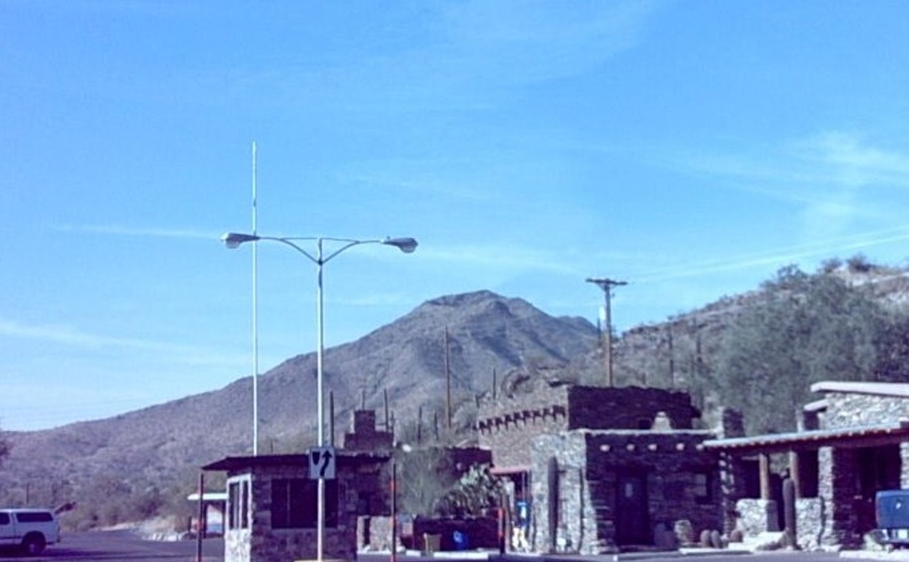
After a year of waiting, Camelback lovers returned in force on January 15 to the renovated Echo Canyon Trail. The short, conveniently located adventure hike, accessed near Tatum Boulevard and McDonald Drive, is one of the most visited attractions in Phoenix and a weekly, or even daily, routine for many locals. Now it's more popular than ever. Although the number of parking spaces has doubled to 135 as part of the $4.5 million project, the spaces still fill quickly each day as jubilant hikers flock to see what the city has done. Except for the parking situation, which eased as the seasonal heat arrived, the renovation generally has been seen as a success. Porta-potties were replaced by real toilets. The summit-bound trail grew slightly to 1.5 miles, with the first section receiving the most redevelopment. The path winds through scenic Echo Canyon before connecting with the old trail, most of which was untouched. Better-protected from erosion, the new trail's ready for years of monsoons and millions of footsteps — some of which could be yours.

Best Comeback Trail
Echo Canyon, Camelback Mountain

- 5950 N. Echo Canyon Parkway, Paradise Valley, 85253 Map
- 602-261-8318
- www.phoenix.gov/recreation/rec/parks/preserves/locations/camelback/index.html
Best Hiking Trail
Tom's Thumb Trail, McDowell Sonoran Conservancy
If you've ever wanted to visit the moon, the landscape of the McDowell Mountains near the rock-skyscraper Tom's Thumb formation might just satisfy the craving — rolling, sparsely vegetated hills, boulders large and small. But first you have to get up there. We usually take Dynamite Boulevard, turn right on 128th Street, and head south until reaching the parking lot. Don't be fooled by the posh, resort-style entranceway at the trailhead — this is Scottsdale, yes, but it's not all easy living on the Tom's Thumb Trail. You'll ascend nearly the height of the Empire State Building over more than two miles of steep trail with switchbacks. Opened just two years ago, the new trail is smooth and mostly free of ankle-twisting rocks. It's tough, but you'll see people of all ages taking it on. Take more water than you think you'll need if the air temperature is anything close to warm, and be sure to save some energy to explore the otherworldly summit ridge for a while.
- 104th St. S. of McDowell Mountain Ranch Rd., Scottsdale, 85259 Map
- www.mcdowellsonoran.org
Best Hiking Guide
Hikers Guide to the Superstition Wilderness: With History and Legends of Arizona's Lost Dutchman Gold Mine by Jack C. Carlson and Elizabeth Stewart
First published more than a decade ago, this hiking and biking guide will inspire even the least-outdoorsy among us to hit the trail. Expert and frequently updated trail descriptions are categorized by difficulty, length, and popularity among hikers, and the book's topographical maps make this book a must-have for any hiker. Step-by-step directions and some really great photography help both the novice and the seasoned hiker choose which trail to take. The "History and Legends" essays, published as part of each hike description, really sets this book apart from other guides covering the National Forest Wilderness of Arizona.
Best Bouldering
South Mountain Park/Preserve
Bouldering in the Pima Canyon wash, near the east end of Phoenix's vast South Mountain Park/Preserve, requires extreme skill, not just because of the difficult routes, which are rated V0 (equivalent to about 5.10 at local rock-climbing gyms — not a beginner rating) to an insane V7, but also because of the scary landings. Bouldering typically involves rock climbing with rock shoes but no rope on routes low enough to fall off without serious injury. In this "developed" climbing area (the short climbing routes are detailed in a pamphlet published by local climber Marty Karabin and found in area outdoors shops), the routes go too high, and have wicked-angled boulders to fall on if you miss a handhold.
So why do we love it? Fact is, we've enjoyed the place many times without finishing a route — that is, we climb up only a few feet, and leave the top-outs for stronger, nuttier athletes. No shame in that — it's bouldering. The idea is to get a good pump. And that we do. The rock quality here is passable, considered "granitic" but not granite. Its boulders often have a veneer of desert varnish, which feels great to grip. Good cracks rise up high enough to practice fist jams and foot placement.
You've got to watch for the inevitable crumbly hand- and footholds. But the expansive, fun-to-explore area of dry waterfalls, varnished boulders, and arroyo sand is worth several hours of your life on a nice day. Often, you'll see some of the local hardmen and women who spend hours a day — every day — on the rock and maybe some of the overconfident klutzes who'll make you want to get your phone ready to call 911. If you spot someone staying safe and low but still having fun, that might be us.
- 10919 S. Central Ave., Phoenix, 85042 Map
- 602-262-7393
- www.phoenix.gov/parks/southmnt.html
Best Rock Climbing Gym
Focus Climbing Center
Unlike most climbing gyms we've been in, Focus mainly is about bouldering. Housed in an industrial building in Mesa just east of the Tempe border on Broadway Road, it has several walls with ropes for belaying climbers and a few auto-belayers that allow a solo climber to ascend the 30-foot routes. But once you pass through the lobby after signing in (and paying $22 for a day pass and rental of harness and rock shoes), the first thing you'll notice in the main room is the impressive, 120-foot-long-by-18-foot-high inverted bouldering wall. The wall imparts on climbers a steady buzz of fear because they aren't roped in.
On our first time, we had to be trained on how to fall properly on the special ultra-cushiony floor surface. They made us hop backward off the wall and land on the mat with our butt, back, and head, arms folded over our chest. It all seemed reasonable until we were actually climbing on the inverted wall, all our weight hanging on our fingertips. Our first fall didn't look as pretty as in practice. But we didn't get hurt, either — the bouncy mat really works. Like other gyms, colored tape is used to designate specific routes up the wall, so you can judge when you're improving. Fortunately, the gym gives discounts for monthly and yearly memberships. With this sport, practice makes badass.
- 2150 W. Broadway Rd., Mesa, 85202 Map
- 480-718-5258
- focusclimbingcenter.com/
Best Mountain Bike Ride
FINS, Estrella Mountain Ranch, Goodyear
A decade ago, some mountain bikers decided to create a single-track paradise for themselves on private Estrella Mountain Ranch land slated for development. They called it Fantasy Island North Singletrack, in honor of Tucson's Fantasy Island biking area. Friends started coming. Unlike skateboarders taking over a strip mall, they didn't get kicked out. Instead, signs were posted for each of the many trails, maps were printed, the secret got out, and the public got turned on to what now resembles a mountain-biking theme park. No purchase is required; just drive west on I-10 to Estrella Parkway, go south 10 miles to Weststar, turn right, park at the school, and bike another half-mile down Weststar to the trails.
Nothing there is too extreme, but some of the trails have sections that are difficult and potentially dangerous. Make sure your brakes are in working order. Someday, the whole area probably will be tamped down under a layer of single-family homes, so load up the bike and get out there while you still can.
Best Group Bike Ride
Summer Solstice Swimsuit Ride by TBAG
Nothing gets you in the summer spirit quite like getting on your bicycle wearing next to nothing and pool-hopping around Tempe. Luckily for folks in the Valley, Tempe Bicycle Action Group has been making a regular event out of it for the past five years with its Summer Solstice Swimsuit ride. The ride is a casual cruising event made for all skill levels to enjoy. Usually, the group will ride from Tempe Beach Park, stopping at private pools, apartment complex pools, fountains, and even a Slip 'N Slide, all in the pursuit of keeping cool and staying on the bike as temperatures rise. The last ride saw cyclists donning skin-tight Speedos with an Arizona flag design. So should you ride next year, you can at least expect a decent view on the way.
Best Road Bike Ride
Third and Fifth avenues in Phoenix
Downtown Phoenix isn't the most bicycle-friendly region of the Valley, but for those living in the area, there's a shred of hope for safe travels on Third and Fifth avenues. If you're looking to go northbound from downtown, take Third Avenue. If you're looking to go southbound to downtown, take Fifth Avenue. That's pretty much law for downtown riders. With a continuous and reasonably sized (for Phoenix) bike lane on both streets, it's an artery that pumps cyclists from uptown to downtown without too much trouble. Sure it isn't the most scenic of rides in the metro area (many favor the Greenbelt in Scottsdale or even the Carefree Highway for more serious riders), but for sheer utility in commuting, we have to give some love to our little avenidas.
Best Motorcycle Ride
Tortilla Flat
There are two kinds of Valley motorcyclists: Those who have been to Tortilla Flat and those who will go to Tortilla Flat. No other local ride puts riders on twisting roads so quickly, yet this convenience requires no sacrifice in quality. The scenery on this ride is truly stunning, featuring breathtaking desert vistas, sharply rising mountain cliffs and a shimmering, blue-green lake. Take U.S. 60 east to the Idaho Road exit, then head northeast on State Route 88, also known as the Apache Trail. Minutes later, you've left civilization (or what passes for it in Apache Junction) and have escaped into the freedom of the hills of Tonto National Forest. About 10 miles after passing Lost Dutchman Park (a great place to begin a Superstition Mountain-area hike), the two-lane highway curves in ways that will test the skills of new riders and put a smile on the face of even the codgiest old biker. Weekend mornings and weekdays are the best times to go, when the Apache Trail isn't likely to be choked with traffic and you can ride at a speed that suits you. At the end of the twisties and after passing over a neat one-lane bridge near Canyon Lake, you arrive at Tortilla Flat, an Arizona ghost town and tourist attraction with a saloon and ice cream store. In peak season, the dirt parking lot outside the shops is hazy with dust and vibrating with the rumble of dozens of motorcycles. Sooner or later, you'll join the crowd.
Best Drive
State Route 87
You take an interstate to get out of Phoenix? What are you, new? Take a drive on State Route 87, which is ideal for anything from a relaxing day drive to a full-blown adventure. Once you catch the road in the East Valley (as Arizona Avenue in Chandler or Country Club Drive in Mesa), it's only minutes before you're on the open road of the Beeline Highway and heading northeast from the Valley. Just a few miles past Fountain Hills, you're in the Tonto National Forest, passing Four Peaks, heading through Payson, and going through some tight turns amid the Mazatzal Mountains. You'll head through the end of the forest and through Winslow, eventually reaching the northern end of the highway in a little town on the Hopi Reservation called Second Mesa. It's at that point you might realize that your scenic drive has left you more than four hours from Phoenix — but it'll be worth it.
Best Of Phoenix®
-
Megalopolitan Life
-
Best of Phoenix 2014: Legend City / Beware of the Arizona Canal Monster
-
Best of Phoenix 2014: Legend City / The Many Mysteries of Acquanetta (and Jack Ross)
-
Best of Phoenix 2014: Legend City / The Phoenix Lights
-
Best of Phoenix 2014: Legend City / Kicking Ash
-
Best of Phoenix 2014: Legend City / Cowgirl's Got the Balls
-
Best of Phoenix 2014: Legend City / Lore of the Lair
-
Best of Phoenix 2014: Legend City / Rescue Me
-
Best of Phoenix 2014: Legend City / Mural of the Story
-
Best of Phoenix 2014: Legend City / Baier, Beware
-
Best of Phoenix 2014: Legend City / Little Green Men in Cave Creek
-
Best of Phoenix 2014: Legend City / White Christmas -- in Phoenix?
-
-
Fun & Games
-
La Vida
-
Best Rise From the Ashes
Restaurant Atoyac Estilo Oaxaca
-
Best Upscale Mexican Restaurant
Los Sombreros
-
Best Latin American Restaurant
República Empanada
-
Best New Mexican Restaurant
Phoenix Burrito House
-
Best Neighborhood Mexican Restaurant
Los Olivos
-
Best Chilaquiles
Pepe's Taco Villa
-
Best Breakfast Burrito
El Norteño
-
Best Burrito
Rito's Mexican Food
-
Best Tacos
Taco Mich
-
Best Enchiladas
Menuderia Guanajuato
-
Best Tamales
La Tolteca
-
Best Torta
Gallo Blanco
-
Best Sonoran Hot Dogs
Nogales Hot Dog
-
Best Pozole
Los Taquitos
-
Best Menudo
Rosita's Place
-
Best Mexican Seafood
Mariscos Altata
-
Best Carne Asada
Asadero Norte de Sonora
-
Best Carniceria
El Rancho Market IGA
-
Best Mexican Grocery Store
Los Altos Ranch Market
-
Best Panaderia
La Purisima Pasteleria
-
Best Tortillas
Carolina's
-
Best Guacamole
Barrio Cafe
-
Best of Phoenix 2014: Legend City / Goat Cheese
-
Best Salsa
Carniceria Los Pinos
-
Best Elote
Fruitlicious
-
Best of Phoenix 2014: Legend City / Miranda Rights and Wrongs
-
Best Nopales Dish
Comedor Guadalajara
-
Best of Phoenix 2014: Legend City / Chimi Battle
-
Best Nopales Drink
Courtyard Café, the Heard Museum
-
Best Aguas Frescas
Gorditas El Tio
-
Best Raspados
Raspados Neza
-
Best Paletas
Realeza Michoacana
-
Best Mexican Candy
Dulceria Pico Rico
-
Best Piñata
Arizona Piñatas
-
Best Yerberia
Yerberia San Francisco
-
Best Place to Buy Mexican Furniture
Meza's in Art
-
Best Place to Buy Mexican Tchotchkes
Mexican Import
-
Best Place to Buy Day of the Dead Treasures
Purple Lizard Boutique
-
Best Spanish-Language Bookstore
Pablo Helguera's "Librería Donceles"
-
Best Latin Night
Fridays at Monarch Theatre
-
Best Immigration Story
Underwater Dreams
-
Best Latin Club
El Capri
-
Best Margarita
Tamarind Margarita La Santisima
-
-
Food & Drink
-
Best New Restaurant
The Local
-
Best Chef
Josh Hebert at Posh Improvisational Cuisine
-
Best Culinary Adventure
#PM31 at T. Cook's
-
Best Food Truck
Jamburritos Cajun Grill Express
-
Best Place to Take a Foodie
Binkley's Restaurant
-
Best Place to Take a Scenester
Lux Central
-
Best Place to Take an Out-of-Towner
Pizzeria Bianco at Town & Country
-
Best Authentic Arizona Restaurant
Rancho Pinot
-
Best Breakfast
Matt's Big Breakfast
-
Best Downtown Lunch
Carolina's
-
Best Sunday Brunch
Bink's Midtown
-
Best Seafood
Angry Crab Shack
-
Best BBQ
Little Miss BBQ
-
Best Steak House
Steak 44
-
Best French Restaurant
Zinc Bistro
-
Best Vietnamese Restaurant
Khai Hoan Restaurant
-
Best Korean Restaurant
Cafe Ga Hyang
-
Best Thai Restaurant
Nunthaporn's Thai Cuisine
-
Best Japanese Restaurant
ShinBay
-
Best Chinese Restaurant
Hong Kong Asian Diner
-
Best Dim Sum
Great Wall Cuisine
-
Best Indian Restaurant
Little India
-
Best Mediterranean Restaurant
Middle Eastern Bakery Deli
-
Best Jewish Deli
Goldman's Deli
-
Best Soul Food Restaurant
Lo-Lo's Chicken and Waffles
-
Best German Restaurant
Haus Murphy's
-
Best Italian Restaurant
Franco's Italian Caffe
-
Best Italian Deli
Romanelli's
-
Best Gourmet Pizza
La Piazza PHX
-
Best Pizza Slice
Mamma Mia
-
Best Cheese
Arizona Cheese Company
-
Best Wings
AZ88
-
Best Grilled Cheese
Palette at Phoenix Art Museum
-
Best Hot Dog
Hot Dog Stop
-
Best Hamburger
Ingo's Tasty Food
-
Best Sandwich
Fried Green Tomato Sandwich at Welcome Diner
-
Best Caesar Salad
Alexi's Grill
-
Best Soup
Chodang Tofu and BBQ
-
Best Ramen
Hana Japanese Eatery
-
Best Escargot
Petite Maison
-
Best Octopus
Virtù Honest Craft
-
Best Sushi
Yasu Sushi Bistro
-
Best Crepes
Crepe Bar
-
Best Vegetables
FnB
-
Best Vegetarian Restaurant
Bragg's Factory Diner
-
Best Vegan Restaurant
Green
-
Best Gluten-Free Restaurant
Grabbagreen
-
Best Gluten-Free Bakery
Jewel's Bakery and Cafe
-
Best Bakery
Barb's Bakery
-
Best English Muffin
La Grande Orange
-
Best Bread
Noble Bread
-
Best Pastries
Merci French Café and Pastisserie
-
Best Cupcake
Urban Cookies
-
Best Candy Store
Super Chunk Sweets and Treats
-
Best Shaved Ice
RaspadoRico
-
Best Milkshake
The Stand
-
Best Ice Cream
Doc's Artisan Ice Cream
-
Best Gelato
Cool Gelato Italiano
-
Best Desserts
Le Napoleon
-
Best Mall Food
Julia Baker Confections at Biltmore Fashion Park
-
Best Food Intersection
Warner and Dobson, Chandler
-
Best Day Off
Day Off Dinner at The Clever Koi
-
Best Place for a First Date
The House Brasserie
-
Best Romantic Dinner
Cafe Monarch
-
Best Restaurant for Kids
St. Francis
-
Best Place to Dine with Your Dog
O.H.S.O. Eatery + nanoBrewery
-
Best View
Jade Bar at Sanctuary
-
Best Patio Dining
Ingo's Tasty Food
-
Best Lounge Food
Onyx Bar & Lounge, Four Seasons Scottsdale at Troon North
-
Best Place to Eat at the Bar
Citizen Public House
-
Best Bar for Day Drinking
Dick's Hideaway
-
Best Wine List
Vintage 95
-
Best Place for After-Dinner Drinks
Hanny's
-
Best Place to Sober Up
Gus' New York Pizza Lounge
-
Best Hangover Breakfast
Snooze, an AM Eatery
-
Best Food Blog
Cucumbers and Limes (cucumberandlimes.tumblr.com)
-
Best Local Food Publication
Edible Phoenix
-
Best Stories About Wine and Food
Stay True Radio
-
Best Menu
Second Story Liquor Bar
-
-
Best of Phoenix 2014: Tales of the City
-
Bars & Clubs
-
Best Place for a Twilight Drink
Four Seasons Resort Scottsdale
-
Best Happy Hour
Bar Crudo
-
Best Local Beer
San Tan's Mr. Pineapple
-
Best Seasonal Beer
Four Peaks' Pumpkin Porter
-
Best Brewery
Arizona Wilderness Brewing Co.
-
Best Wine Bar
Kazimierz World Wine Bar
-
Best Sangria
Crescent Ballroom
-
Best Bloody Mary
RnR
-
Best Barrel-Aged Cocktail
Citizen R+D's Sea Salt Negroni
-
Best Cocktail by the Pitcher
Pitcha of Pimm's at Windsor
-
Best Moonshine
Bootleggers
-
Best Whiskey Bar
Magnum's Cigar Bar
-
Best Old School Cocktails
Second Story Liquor Bar
-
Best New School Cocktails
The Clever Koi
-
Best Place for Drinks After a Show
AZ88
-
Best Cocktail Program
Last Drop Bar at the Hermosa Inn
-
Best Fireside Drinks
House of Tricks
-
Best Place to Drink and Work
Lux Central
-
Best Bartender
Geoffrey Wilson at Barrelhouse
-
Best DJ
DJ Smite
-
Best Turntablist
Fact135
-
Best Sideman
Jon Rauhouse
-
Best Tribute Band
One More Time — A Tribute to Daft Punk
-
Best Local Band
Andrew Jackson Jihad
-
Best Local Music Label
Rubber Brother Records
-
Best World Music Label
Canyon Records
-
Best Bar in a Bookstore
First Draft Book Bar
-
Best Cocktail Stories
Arizona Cocktail Hour
-
Best Songwriter
Mike Condello
-
Best Radio Morning Show
The Morning Infidelity on KWSS 93.9 FM
-
Best Alternative/Rock Radio Station
KWSS 93.9 FM
-
Best Classic Rock Radio Station
KCDX 103.1 FM
-
Best R&B Radio Station
Mega 104.3
-
Best Hip-Hop Radio Station
101.1 The Beat
-
Best Blues/Jazz Radio Station
KJZZ 91.5 FM
-
Best Storytelling MC
Dan Hull
-
Best Country Radio Station
KSWG 96.3 FM
-
Best Arena Show
Paul McCartney at US Airways Center
-
Best Theater Show
Lindsey Stirling at Marquee Theatre
-
Best Club Show
The Phoenix Rock Lottery at Crescent Ballroom
-
Best Bar for Local Acts
The Lost Leaf
-
Best Venue for Local Acts
Crescent Ballroom
-
Best Venue for National Acts
Orpheum Theater
-
Best New Venue
The Pressroom
-
Best New Nightclub
Cake Nightclub
-
Best Nightclub
Maya Day & Nightclub
-
Best Rock Club
Joe's Grotto
-
Best Punk Venue
Nile Theater / The Underground
-
Best Jazz Joint
The Nash
-
Best Blues Club
Rhythm Room
-
Best Rockabilly Bar
Rips Ales & Cocktails
-
Best Country and Western Nightspot
Dierks Bentley's Whiskey Row
-
Best Hip-Hop Series
Blunt Club at Yucca Tap Room
-
Best Weekly Dance Night
Kismet, Saturdays in Crescent Ballroom's Lounge
-
Best Monthly Dance Night
Tongue Tied, First Saturdays at Apollo's Lounge
-
Best Dance Floor
Monarch Theatre
-
Best Gay Dance Club
Karamba Night Club
-
Best Gay Bar
Charlie's
-
Best Lesbian Bar
Cash Inn Country
-
Best Resort Bar
BLT Steak at Camelback Inn
-
Best Dive Bar
Royale Lounge
-
Best English Pub
Rose & Crown Pub
-
Best Irish Pub
Rosie McCaffrey's
-
Best Smoking Patio
Shady's Fine Ales & Cocktails
-
Best Sports Bar
Duke's Sports Bar
-
Best Pool Hall
Q & Brew
-
Best Adult Arcade
Gypsy Bar
-
Best Place to See a Comedy Show
Stand Up Live
-
Best Onstage Freakout
Destruction Unit
-
Best Industry Night
Lustre Bar
-
Best After-Hours
Karamba Nightclub
-
-
Goods / Services
-
People & Places
-
Best Urban Legend
Phoenix Has No Culture
-
Best Selfie
Daniel Funkhouser's Artselfie
-
Best Scavenger Hunt
James B. Hunt's "Art Hide"
-
Best Arts Festival
ARTELPHX
-
Best Craft Festival
Crafeteria
-
Best Dance Festival
CONDER/dance's "Breaking Ground" at Tempe Center for the Arts
-
Best Film Festival
Phoenix Film Festival
-
Best Music Festival
Viva PHX
-
Best Place to Learn to Tell Tales
South Mountain Community College Storytelling Institute
-
Best Culinary Festival
Devoured Food + Wine Classic
-
Best Beer Festival
Real, Wild, and Woody
-
Best Cocktail Event
Arizona Cocktail Week
-
Best Mural Event
Paint PHX
-
Best Gaming Event
ZapCon
-
Best Casino
Talking Stick Resort
-
Best Place to Geek Out
Phoenix Comicon
-
Best Paranormal Convention
UFO Congress Radisson Fort McDowell Resort & Casino
-
Best Home Tour
Modern Phoenix
-
Best Neighborhood
Arcadia Lite
-
Best Up-and-Coming Neighborhood
Garfield Historic District
-
Best Art at a Library
Camp Dreamtree at Scottsdale Public Library
-
Best Storytelling for the Masses
Arizona Storytellers Project
-
Best Independent Movie Theater
FilmBar
-
Best Budget Movie Theater
Pollack Tempe Cinemas
-
Best Luxury Movie Theater
AMC Esplanade 14
-
Best Cult Movie Series
Cult Classics at Pollack Tempe Cinemas
-
Best Place to Spot a Celebrity
Gainey Village Health Club
-
Best People Watching
Arizona State Fair
-
Best Bathroom
He/She bathroom at AZ88
-
Best Literary Journal
Four Chambers Press
-
Best Spoken-Word Series
Lit Lounge at Scottsdale Museum of Contemporary Art
-
Best Place to Be Seen
Phoenix Art Museum on First Friday
-
Best Art Gallery
Lisa Sette Gallery
-
Best New Gallery
Halt Gallery
-
Best Pop-Up Gallery
Hot Box Gallery
-
Best Student Gallery
Art One
-
Best First Friday Hangout
Grant Street Studios
-
Best Stop on Art Detour
"Apache X: 10 Years of Douglas Miles and Apache Skateboards" at MonOrchid
-
Best Temporary Public Art
Sarah Hurwitz's Participation Prize
-
Best Permanent Public Art
James Turrell's Knight Rise
-
Best Graffiti Artist
El Peezo
-
Best Poet
Alberto Álvaro Ríos
-
Best Mural
JBAK's Generations
-
Best Designer
Monique Sandoval
-
Best Left-Wing Blog
Steve Muratore's Arizona Eagletarian
-
Best Right-Wing Blog
Seeing Red AZ
-
Best Lifestyle Blog
Field & Fellow
-
Best Zine
Michael Max McLeod's Texas Porno Roadtrip
-
Best Library
Desert Foothills Library
-
Best Model
Alexis Hamilton
-
Best Fashion Collaboration
Bunky x Sentrock at Bunky Boutique
-
Best Fashion Week Cameo
Robert Black
-
Best Creative Collaboration
The Creative Center
-
Best Phoenician to Follow on Instagram
Helen Yung
-
Best Phoenician to Follow on Twitter
Robbie Sherwood
-
Best Politician
Congressman Ed Pastor
-
Best Power Couple
Kate and Ruben Gallego
-
Best Cry Baby
John Huppenthal
-
Best Political Zombie
Tom Horne
-
Best Prosecutor Who Should Be Attorney General
Yavapai County Attorney Sheila Polk
-
Best Joe Arpaio Jokes
State Representative John Kavanagh
-
Best Smackdown
Judge G. Murray Snow
-
Best Self-Inflicted Wound
The Arizona GOP's Censure of U.S. Senator John McCain
-
Best Example of Religious Extremism
Cathi Herrod of Center for Arizona Policy
-
Best Unpaid Political Strategist
Tyler Montague, president of the Arizona Public Integrity Alliance
-
Best Public Information Officer
Matt Roberts of the Arizona Secretary of State's Office
-
Best TV Host
Ted Simons of KAET Channel 8
-
Best TV Newscaster
Carey Peña, KTVK Channel 3
-
Best YA Author
Tom Leveen
-
Best Poetry Slam
Phoenix Poetry Slam
-
Best News Radio Station
KJZZ 91.5 FM
-
Best In-the-Works Radio Station
102.9 FM
-
Best Dancer
Gavin Sisson
-
Best Digital Magazine
Emma
-
Best Performance Art Series
Performance in the Borderlands
-
Best Actor
Jon Gentry in Around the World in 80 Days
-
Best Actress
Shari Watts in August: Osage County
-
Best Performance by a Child Actor in a Professional Production
Riley Glick in Ruthless! The Musical
-
Best Theater Director
Ron May
-
Best Playwright
Dwayne Hartford
-
Best Professional Theater
Arizona Theatre Company
-
Best Children's Theater
Childsplay
-
Best New Black Box
Phoenix Theatre's Black Box Space
-
Best Community Theater
Stray Cat
-
Best Stage Surprise
Mary's Wedding, Theatre Artists Studio
-
Best Reason to Go to the Theater All Season
Damon Dering in The Whale
-
Best Return from the Theatrical Grave
Actors Theatre
-
Best Trip Down Memory Lane
Vintage Phoenix
-
-
Shopping & Services
-
Best Coffee House
Altitude Coffee Lab
-
Best Coffee Roaster
Cartel Coffee Lab
-
Best Market
French Grocery
-
Best Farmers Market
Old Town Farmers Market
-
Best Cocktail Class
Jade Bar at Sanctuary on Camelback Mountain
-
Best Hangover Cure
The Drip Room
-
Best Place to Buy Wine
Wedge and Bottle
-
Best Distillery
Arizona Distilling Co.
-
Best Liquor Store
Tops Liquor
-
Best Head Shop
Bud's Glass Joint
-
Best Medical Marijuana Edibles
Aunt Effie's Mini Snickerdoodles at Phoenix Relief Center
-
Best Place for a Complete Medical Marijuana Experience
Medical Marijuana Farmers Market
-
Best Medical Marijuana Concentrates
Encanto Green Cross
-
Best MMJ Hybrid Strain
Blue Dream at Harvest of Tempe
-
Best MMJ Sativa Strain
Durban Poison at Horizon the Health Center
-
Best Customer Perks at a Medical Marijuana Dispensary
AZ Natural Selections
-
Best Nursery
Harper's Nursery
-
Best Free Wilderness Classes
REI
-
Best Floral Class
Pith and Marrow
-
Best Florist
Camelback Flower Shop
-
Best Beauty Supply Store
Citrine Natural Beauty Bar
-
Best Pet Groomer
Villa La Paws Unleashed
-
Best Spa
VH Spa at Hotel Valley Ho
-
Best DIY Pet Groomer
Wag N' Wash
-
Best Car
Tesla
-
Best Bike Shop
Slippery Pig Bicycles
-
Best Running Store
Road Runner Sports Scottsdale
-
Best Audiophile Equipment
Arizona Hi-Fi
-
Best Record Store for CDs
Stinkweeds
-
Best Record Store for Vinyl
Revolver Records
-
Best Dollar Store
Dollar Tree
-
Best Shopping Co-op
Double Nickels Collective
-
Best Multimedia Resale
Zia Record Exchange
-
Best Bookstore
Changing Hands Bookstore
-
Best Comic Book Shop
All About Books and Comics
-
Best Used Bookstore
The Bookshop
-
Best Magazine Rack
Bookmans Entertainment Exchange
-
Best Adult Clothing Resale
Buffalo Exchange
-
Best Kid Clothing Resale
Love Child Style Exchange
-
Best Kids' Clothing
Baby Teith
-
Best Jewelry
Mother of Gideon
-
Best T-Shirts
Hello Apparel
-
Best Leather Goods
Bison Made
-
Best Denim
Lawless Denim Co.
-
Best Men's Boutique
HUB
-
Best New Boutique
Pepper
-
Best Boutique
Frances
-
Best Homegrown Boutique
GROWop
-
Best Online Vintage Boutique
Luxie Vintage
-
Best Place to Buy Vintage Clothing
Vintage by Misty
-
Best Vintage Market
Junk in the Trunk at WestWorld of Scottsdale
-
Best Antiques Mall
Antiques on Central
-
Best Place to Buy High-End Antiques
Rare Lion
-
Best Place to Buy Antiques on a Budget
Zinnias at Melrose
-
Best Midcentury Antiques
Modern on Melrose
-
Best Midcentury Modern Furniture
Red Modern
-
Best Art Supply Store
Arizona Art Supply
-
Best Home Goods
Bungalow
-
Best Place to Buy Wallpaper
Wallpaper and Border Store
-
Best Knitting Supplies
Tempe Yarn and Fiber
-
Best Costume Store
Easley's Fun Shop
-
Best Shopping on Mill Avenue
Brand X
-
Best Shopping on Roosevelt Row
Curious Nature
-
Best Shopping on Grand Avenue
Hazel & Violet
-
Best Gift Shop
Design Lab
-
Best Mall
Scottsdale Fashion Square
-
-
Sports & Recreation
-
Best Path
Bridle Path on Central Avenue at Bethany Home Road
-
Best Comeback Trail
Echo Canyon, Camelback Mountain
-
Best Hiking Trail
Tom's Thumb Trail, McDowell Sonoran Conservancy
-
Best Hiking Guide
Hikers Guide to the Superstition Wilderness: With History and Legends of Arizona's Lost Dutchman Gold Mine by Jack C. Carlson and Elizabeth Stewart
-
Best Bouldering
South Mountain Park/Preserve
-
Best Rock Climbing Gym
Focus Climbing Center
-
Best Mountain Bike Ride
FINS, Estrella Mountain Ranch, Goodyear
-
Best Group Bike Ride
Summer Solstice Swimsuit Ride by TBAG
-
Best Road Bike Ride
Third and Fifth avenues in Phoenix
-
Best Motorcycle Ride
Tortilla Flat
-
Best Drive
State Route 87
-
Best Travel Magazine
Arizona Highways
-
Best Place to Drive Like a Maniac
National Auto Sport Association, Arizona Region
-
Best Go-Karts
Octane Raceway
-
Best Museum for Gearheads
Penske Racing Museum
-
Best Mock Western Town
Camelback Inn
-
Best Tourist Attraction
Desert Botanical Garden
-
Best Daytime Date Spot
Japanese Friendship Garden
-
Best Yoga with a View
Rooftop Yoga at Lustre Rooftop Garden
-
Best Cheap Yoga
Dirty Yoga
-
Best Pool Party
Release Pool Party at Talking Stick
-
Best Hotel Pool
Hyatt Gainey Ranch
-
Best Water Park
Wet 'n' Wild
-
Best Dog Park
Margaret T. Hance Park
-
Best Miniature Golf
Castles 'n' Coasters
-
Best Golf Course
We-Ko-Pa Golf Club (Saguaro Course)
-
Best Place to Watch Spring Training
Cubs Park
-
Best Coach
Bruce Arians
-
Best Team Owner
Robert Sarver
-
Best Reason to Believe the Diamondbacks Have a Bright Future
Sports Exec Tony LaRussa
-
Best Slugger
Paul Goldschmidt
-
Best Pitcher
Patrick Corbin
-
Best Basketball Players
Goran Dragic and Eric Bledsoe
-
Best Football Player
Patrick Peterson
-
Best Sports Phenom
Brittney Griner
-
Best Sports Expatriate
Steve Kerr
-
Best Sports Legend
Basketball player, coach, and broadcaster Doug Collins
-
Best Rock Climbing
Gardener's Wall at McDowell Sonoran Conservancy
-
-
Bars & Nightlife
-
Finefood
-
Readers' Choice
Best Of
-
Megalopolitan Life
-
Best of Phoenix 2014: Legend City / Beware of the Arizona Canal Monster
-
Best of Phoenix 2014: Legend City / The Many Mysteries of Acquanetta (and Jack Ross)
-
Best of Phoenix 2014: Legend City / The Phoenix Lights
-
Best of Phoenix 2014: Legend City / Kicking Ash
-
Best of Phoenix 2014: Legend City / Cowgirl's Got the Balls
-
Best of Phoenix 2014: Legend City / Lore of the Lair
-
Best of Phoenix 2014: Legend City / Rescue Me
-
Best of Phoenix 2014: Legend City / Mural of the Story
-
Best of Phoenix 2014: Legend City / Baier, Beware
-
Best of Phoenix 2014: Legend City / Little Green Men in Cave Creek
-
Best of Phoenix 2014: Legend City / White Christmas -- in Phoenix?
-
-
Fun & Games
-
La Vida
-
Best Rise From the Ashes
Restaurant Atoyac Estilo Oaxaca
-
Best Upscale Mexican Restaurant
Los Sombreros
-
Best Latin American Restaurant
República Empanada
-
Best New Mexican Restaurant
Phoenix Burrito House
-
Best Neighborhood Mexican Restaurant
Los Olivos
-
Best Chilaquiles
Pepe's Taco Villa
-
Best Breakfast Burrito
El Norteño
-
Best Burrito
Rito's Mexican Food
-
Best Tacos
Taco Mich
-
Best Enchiladas
Menuderia Guanajuato
-
Best Tamales
La Tolteca
-
Best Torta
Gallo Blanco
-
Best Sonoran Hot Dogs
Nogales Hot Dog
-
Best Pozole
Los Taquitos
-
Best Menudo
Rosita's Place
-
Best Mexican Seafood
Mariscos Altata
-
Best Carne Asada
Asadero Norte de Sonora
-
Best Carniceria
El Rancho Market IGA
-
Best Mexican Grocery Store
Los Altos Ranch Market
-
Best Panaderia
La Purisima Pasteleria
-
Best Tortillas
Carolina's
-
Best Guacamole
Barrio Cafe
-
Best of Phoenix 2014: Legend City / Goat Cheese
-
Best Salsa
Carniceria Los Pinos
-
Best Elote
Fruitlicious
-
Best of Phoenix 2014: Legend City / Miranda Rights and Wrongs
-
Best Nopales Dish
Comedor Guadalajara
-
Best of Phoenix 2014: Legend City / Chimi Battle
-
Best Nopales Drink
Courtyard Café, the Heard Museum
-
Best Aguas Frescas
Gorditas El Tio
-
Best Raspados
Raspados Neza
-
Best Paletas
Realeza Michoacana
-
Best Mexican Candy
Dulceria Pico Rico
-
Best Piñata
Arizona Piñatas
-
Best Yerberia
Yerberia San Francisco
-
Best Place to Buy Mexican Furniture
Meza's in Art
-
Best Place to Buy Mexican Tchotchkes
Mexican Import
-
Best Place to Buy Day of the Dead Treasures
Purple Lizard Boutique
-
Best Spanish-Language Bookstore
Pablo Helguera's "Librería Donceles"
-
Best Latin Night
Fridays at Monarch Theatre
-
Best Immigration Story
Underwater Dreams
-
Best Latin Club
El Capri
-
Best Margarita
Tamarind Margarita La Santisima
-
-
Food & Drink
-
Best New Restaurant
The Local
-
Best Chef
Josh Hebert at Posh Improvisational Cuisine
-
Best Culinary Adventure
#PM31 at T. Cook's
-
Best Food Truck
Jamburritos Cajun Grill Express
-
Best Place to Take a Foodie
Binkley's Restaurant
-
Best Place to Take a Scenester
Lux Central
-
Best Place to Take an Out-of-Towner
Pizzeria Bianco at Town & Country
-
Best Authentic Arizona Restaurant
Rancho Pinot
-
Best Breakfast
Matt's Big Breakfast
-
Best Downtown Lunch
Carolina's
-
Best Sunday Brunch
Bink's Midtown
-
Best Seafood
Angry Crab Shack
-
Best BBQ
Little Miss BBQ
-
Best Steak House
Steak 44
-
Best French Restaurant
Zinc Bistro
-
Best Vietnamese Restaurant
Khai Hoan Restaurant
-
Best Korean Restaurant
Cafe Ga Hyang
-
Best Thai Restaurant
Nunthaporn's Thai Cuisine
-
Best Japanese Restaurant
ShinBay
-
Best Chinese Restaurant
Hong Kong Asian Diner
-
Best Dim Sum
Great Wall Cuisine
-
Best Indian Restaurant
Little India
-
Best Mediterranean Restaurant
Middle Eastern Bakery Deli
-
Best Jewish Deli
Goldman's Deli
-
Best Soul Food Restaurant
Lo-Lo's Chicken and Waffles
-
Best German Restaurant
Haus Murphy's
-
Best Italian Restaurant
Franco's Italian Caffe
-
Best Italian Deli
Romanelli's
-
Best Gourmet Pizza
La Piazza PHX
-
Best Pizza Slice
Mamma Mia
-
Best Cheese
Arizona Cheese Company
-
Best Wings
AZ88
-
Best Grilled Cheese
Palette at Phoenix Art Museum
-
Best Hot Dog
Hot Dog Stop
-
Best Hamburger
Ingo's Tasty Food
-
Best Sandwich
Fried Green Tomato Sandwich at Welcome Diner
-
Best Caesar Salad
Alexi's Grill
-
Best Soup
Chodang Tofu and BBQ
-
Best Ramen
Hana Japanese Eatery
-
Best Escargot
Petite Maison
-
Best Octopus
Virtù Honest Craft
-
Best Sushi
Yasu Sushi Bistro
-
Best Crepes
Crepe Bar
-
Best Vegetables
FnB
-
Best Vegetarian Restaurant
Bragg's Factory Diner
-
Best Vegan Restaurant
Green
-
Best Gluten-Free Restaurant
Grabbagreen
-
Best Gluten-Free Bakery
Jewel's Bakery and Cafe
-
Best Bakery
Barb's Bakery
-
Best English Muffin
La Grande Orange
-
Best Bread
Noble Bread
-
Best Pastries
Merci French Café and Pastisserie
-
Best Cupcake
Urban Cookies
-
Best Candy Store
Super Chunk Sweets and Treats
-
Best Shaved Ice
RaspadoRico
-
Best Milkshake
The Stand
-
Best Ice Cream
Doc's Artisan Ice Cream
-
Best Gelato
Cool Gelato Italiano
-
Best Desserts
Le Napoleon
-
Best Mall Food
Julia Baker Confections at Biltmore Fashion Park
-
Best Food Intersection
Warner and Dobson, Chandler
-
Best Day Off
Day Off Dinner at The Clever Koi
-
Best Place for a First Date
The House Brasserie
-
Best Romantic Dinner
Cafe Monarch
-
Best Restaurant for Kids
St. Francis
-
Best Place to Dine with Your Dog
O.H.S.O. Eatery + nanoBrewery
-
Best View
Jade Bar at Sanctuary
-
Best Patio Dining
Ingo's Tasty Food
-
Best Lounge Food
Onyx Bar & Lounge, Four Seasons Scottsdale at Troon North
-
Best Place to Eat at the Bar
Citizen Public House
-
Best Bar for Day Drinking
Dick's Hideaway
-
Best Wine List
Vintage 95
-
Best Place for After-Dinner Drinks
Hanny's
-
Best Place to Sober Up
Gus' New York Pizza Lounge
-
Best Hangover Breakfast
Snooze, an AM Eatery
-
Best Food Blog
Cucumbers and Limes (cucumberandlimes.tumblr.com)
-
Best Local Food Publication
Edible Phoenix
-
Best Stories About Wine and Food
Stay True Radio
-
Best Menu
Second Story Liquor Bar
-
-
Best of Phoenix 2014: Tales of the City
-
Bars & Clubs
-
Best Place for a Twilight Drink
Four Seasons Resort Scottsdale
-
Best Happy Hour
Bar Crudo
-
Best Local Beer
San Tan's Mr. Pineapple
-
Best Seasonal Beer
Four Peaks' Pumpkin Porter
-
Best Brewery
Arizona Wilderness Brewing Co.
-
Best Wine Bar
Kazimierz World Wine Bar
-
Best Sangria
Crescent Ballroom
-
Best Bloody Mary
RnR
-
Best Barrel-Aged Cocktail
Citizen R+D's Sea Salt Negroni
-
Best Cocktail by the Pitcher
Pitcha of Pimm's at Windsor
-
Best Moonshine
Bootleggers
-
Best Whiskey Bar
Magnum's Cigar Bar
-
Best Old School Cocktails
Second Story Liquor Bar
-
Best New School Cocktails
The Clever Koi
-
Best Place for Drinks After a Show
AZ88
-
Best Cocktail Program
Last Drop Bar at the Hermosa Inn
-
Best Fireside Drinks
House of Tricks
-
Best Place to Drink and Work
Lux Central
-
Best Bartender
Geoffrey Wilson at Barrelhouse
-
Best DJ
DJ Smite
-
Best Turntablist
Fact135
-
Best Sideman
Jon Rauhouse
-
Best Tribute Band
One More Time — A Tribute to Daft Punk
-
Best Local Band
Andrew Jackson Jihad
-
Best Local Music Label
Rubber Brother Records
-
Best World Music Label
Canyon Records
-
Best Bar in a Bookstore
First Draft Book Bar
-
Best Cocktail Stories
Arizona Cocktail Hour
-
Best Songwriter
Mike Condello
-
Best Radio Morning Show
The Morning Infidelity on KWSS 93.9 FM
-
Best Alternative/Rock Radio Station
KWSS 93.9 FM
-
Best Classic Rock Radio Station
KCDX 103.1 FM
-
Best R&B Radio Station
Mega 104.3
-
Best Hip-Hop Radio Station
101.1 The Beat
-
Best Blues/Jazz Radio Station
KJZZ 91.5 FM
-
Best Storytelling MC
Dan Hull
-
Best Country Radio Station
KSWG 96.3 FM
-
Best Arena Show
Paul McCartney at US Airways Center
-
Best Theater Show
Lindsey Stirling at Marquee Theatre
-
Best Club Show
The Phoenix Rock Lottery at Crescent Ballroom
-
Best Bar for Local Acts
The Lost Leaf
-
Best Venue for Local Acts
Crescent Ballroom
-
Best Venue for National Acts
Orpheum Theater
-
Best New Venue
The Pressroom
-
Best New Nightclub
Cake Nightclub
-
Best Nightclub
Maya Day & Nightclub
-
Best Rock Club
Joe's Grotto
-
Best Punk Venue
Nile Theater / The Underground
-
Best Jazz Joint
The Nash
-
Best Blues Club
Rhythm Room
-
Best Rockabilly Bar
Rips Ales & Cocktails
-
Best Country and Western Nightspot
Dierks Bentley's Whiskey Row
-
Best Hip-Hop Series
Blunt Club at Yucca Tap Room
-
Best Weekly Dance Night
Kismet, Saturdays in Crescent Ballroom's Lounge
-
Best Monthly Dance Night
Tongue Tied, First Saturdays at Apollo's Lounge
-
Best Dance Floor
Monarch Theatre
-
Best Gay Dance Club
Karamba Night Club
-
Best Gay Bar
Charlie's
-
Best Lesbian Bar
Cash Inn Country
-
Best Resort Bar
BLT Steak at Camelback Inn
-
Best Dive Bar
Royale Lounge
-
Best English Pub
Rose & Crown Pub
-
Best Irish Pub
Rosie McCaffrey's
-
Best Smoking Patio
Shady's Fine Ales & Cocktails
-
Best Sports Bar
Duke's Sports Bar
-
Best Pool Hall
Q & Brew
-
Best Adult Arcade
Gypsy Bar
-
Best Place to See a Comedy Show
Stand Up Live
-
Best Onstage Freakout
Destruction Unit
-
Best Industry Night
Lustre Bar
-
Best After-Hours
Karamba Nightclub
-
-
Goods / Services
-
People & Places
-
Best Urban Legend
Phoenix Has No Culture
-
Best Selfie
Daniel Funkhouser's Artselfie
-
Best Scavenger Hunt
James B. Hunt's "Art Hide"
-
Best Arts Festival
ARTELPHX
-
Best Craft Festival
Crafeteria
-
Best Dance Festival
CONDER/dance's "Breaking Ground" at Tempe Center for the Arts
-
Best Film Festival
Phoenix Film Festival
-
Best Music Festival
Viva PHX
-
Best Place to Learn to Tell Tales
South Mountain Community College Storytelling Institute
-
Best Culinary Festival
Devoured Food + Wine Classic
-
Best Beer Festival
Real, Wild, and Woody
-
Best Cocktail Event
Arizona Cocktail Week
-
Best Mural Event
Paint PHX
-
Best Gaming Event
ZapCon
-
Best Casino
Talking Stick Resort
-
Best Place to Geek Out
Phoenix Comicon
-
Best Paranormal Convention
UFO Congress Radisson Fort McDowell Resort & Casino
-
Best Home Tour
Modern Phoenix
-
Best Neighborhood
Arcadia Lite
-
Best Up-and-Coming Neighborhood
Garfield Historic District
-
Best Art at a Library
Camp Dreamtree at Scottsdale Public Library
-
Best Storytelling for the Masses
Arizona Storytellers Project
-
Best Independent Movie Theater
FilmBar
-
Best Budget Movie Theater
Pollack Tempe Cinemas
-
Best Luxury Movie Theater
AMC Esplanade 14
-
Best Cult Movie Series
Cult Classics at Pollack Tempe Cinemas
-
Best Place to Spot a Celebrity
Gainey Village Health Club
-
Best People Watching
Arizona State Fair
-
Best Bathroom
He/She bathroom at AZ88
-
Best Literary Journal
Four Chambers Press
-
Best Spoken-Word Series
Lit Lounge at Scottsdale Museum of Contemporary Art
-
Best Place to Be Seen
Phoenix Art Museum on First Friday
-
Best Art Gallery
Lisa Sette Gallery
-
Best New Gallery
Halt Gallery
-
Best Pop-Up Gallery
Hot Box Gallery
-
Best Student Gallery
Art One
-
Best First Friday Hangout
Grant Street Studios
-
Best Stop on Art Detour
"Apache X: 10 Years of Douglas Miles and Apache Skateboards" at MonOrchid
-
Best Temporary Public Art
Sarah Hurwitz's Participation Prize
-
Best Permanent Public Art
James Turrell's Knight Rise
-
Best Graffiti Artist
El Peezo
-
Best Poet
Alberto Álvaro Ríos
-
Best Mural
JBAK's Generations
-
Best Designer
Monique Sandoval
-
Best Left-Wing Blog
Steve Muratore's Arizona Eagletarian
-
Best Right-Wing Blog
Seeing Red AZ
-
Best Lifestyle Blog
Field & Fellow
-
Best Zine
Michael Max McLeod's Texas Porno Roadtrip
-
Best Library
Desert Foothills Library
-
Best Model
Alexis Hamilton
-
Best Fashion Collaboration
Bunky x Sentrock at Bunky Boutique
-
Best Fashion Week Cameo
Robert Black
-
Best Creative Collaboration
The Creative Center
-
Best Phoenician to Follow on Instagram
Helen Yung
-
Best Phoenician to Follow on Twitter
Robbie Sherwood
-
Best Politician
Congressman Ed Pastor
-
Best Power Couple
Kate and Ruben Gallego
-
Best Cry Baby
John Huppenthal
-
Best Political Zombie
Tom Horne
-
Best Prosecutor Who Should Be Attorney General
Yavapai County Attorney Sheila Polk
-
Best Joe Arpaio Jokes
State Representative John Kavanagh
-
Best Smackdown
Judge G. Murray Snow
-
Best Self-Inflicted Wound
The Arizona GOP's Censure of U.S. Senator John McCain
-
Best Example of Religious Extremism
Cathi Herrod of Center for Arizona Policy
-
Best Unpaid Political Strategist
Tyler Montague, president of the Arizona Public Integrity Alliance
-
Best Public Information Officer
Matt Roberts of the Arizona Secretary of State's Office
-
Best TV Host
Ted Simons of KAET Channel 8
-
Best TV Newscaster
Carey Peña, KTVK Channel 3
-
Best YA Author
Tom Leveen
-
Best Poetry Slam
Phoenix Poetry Slam
-
Best News Radio Station
KJZZ 91.5 FM
-
Best In-the-Works Radio Station
102.9 FM
-
Best Dancer
Gavin Sisson
-
Best Digital Magazine
Emma
-
Best Performance Art Series
Performance in the Borderlands
-
Best Actor
Jon Gentry in Around the World in 80 Days
-
Best Actress
Shari Watts in August: Osage County
-
Best Performance by a Child Actor in a Professional Production
Riley Glick in Ruthless! The Musical
-
Best Theater Director
Ron May
-
Best Playwright
Dwayne Hartford
-
Best Professional Theater
Arizona Theatre Company
-
Best Children's Theater
Childsplay
-
Best New Black Box
Phoenix Theatre's Black Box Space
-
Best Community Theater
Stray Cat
-
Best Stage Surprise
Mary's Wedding, Theatre Artists Studio
-
Best Reason to Go to the Theater All Season
Damon Dering in The Whale
-
Best Return from the Theatrical Grave
Actors Theatre
-
Best Trip Down Memory Lane
Vintage Phoenix
-
-
Shopping & Services
-
Best Coffee House
Altitude Coffee Lab
-
Best Coffee Roaster
Cartel Coffee Lab
-
Best Market
French Grocery
-
Best Farmers Market
Old Town Farmers Market
-
Best Cocktail Class
Jade Bar at Sanctuary on Camelback Mountain
-
Best Hangover Cure
The Drip Room
-
Best Place to Buy Wine
Wedge and Bottle
-
Best Distillery
Arizona Distilling Co.
-
Best Liquor Store
Tops Liquor
-
Best Head Shop
Bud's Glass Joint
-
Best Medical Marijuana Edibles
Aunt Effie's Mini Snickerdoodles at Phoenix Relief Center
-
Best Place for a Complete Medical Marijuana Experience
Medical Marijuana Farmers Market
-
Best Medical Marijuana Concentrates
Encanto Green Cross
-
Best MMJ Hybrid Strain
Blue Dream at Harvest of Tempe
-
Best MMJ Sativa Strain
Durban Poison at Horizon the Health Center
-
Best Customer Perks at a Medical Marijuana Dispensary
AZ Natural Selections
-
Best Nursery
Harper's Nursery
-
Best Free Wilderness Classes
REI
-
Best Floral Class
Pith and Marrow
-
Best Florist
Camelback Flower Shop
-
Best Beauty Supply Store
Citrine Natural Beauty Bar
-
Best Pet Groomer
Villa La Paws Unleashed
-
Best Spa
VH Spa at Hotel Valley Ho
-
Best DIY Pet Groomer
Wag N' Wash
-
Best Car
Tesla
-
Best Bike Shop
Slippery Pig Bicycles
-
Best Running Store
Road Runner Sports Scottsdale
-
Best Audiophile Equipment
Arizona Hi-Fi
-
Best Record Store for CDs
Stinkweeds
-
Best Record Store for Vinyl
Revolver Records
-
Best Dollar Store
Dollar Tree
-
Best Shopping Co-op
Double Nickels Collective
-
Best Multimedia Resale
Zia Record Exchange
-
Best Bookstore
Changing Hands Bookstore
-
Best Comic Book Shop
All About Books and Comics
-
Best Used Bookstore
The Bookshop
-
Best Magazine Rack
Bookmans Entertainment Exchange
-
Best Adult Clothing Resale
Buffalo Exchange
-
Best Kid Clothing Resale
Love Child Style Exchange
-
Best Kids' Clothing
Baby Teith
-
Best Jewelry
Mother of Gideon
-
Best T-Shirts
Hello Apparel
-
Best Leather Goods
Bison Made
-
Best Denim
Lawless Denim Co.
-
Best Men's Boutique
HUB
-
Best New Boutique
Pepper
-
Best Boutique
Frances
-
Best Homegrown Boutique
GROWop
-
Best Online Vintage Boutique
Luxie Vintage
-
Best Place to Buy Vintage Clothing
Vintage by Misty
-
Best Vintage Market
Junk in the Trunk at WestWorld of Scottsdale
-
Best Antiques Mall
Antiques on Central
-
Best Place to Buy High-End Antiques
Rare Lion
-
Best Place to Buy Antiques on a Budget
Zinnias at Melrose
-
Best Midcentury Antiques
Modern on Melrose
-
Best Midcentury Modern Furniture
Red Modern
-
Best Art Supply Store
Arizona Art Supply
-
Best Home Goods
Bungalow
-
Best Place to Buy Wallpaper
Wallpaper and Border Store
-
Best Knitting Supplies
Tempe Yarn and Fiber
-
Best Costume Store
Easley's Fun Shop
-
Best Shopping on Mill Avenue
Brand X
-
Best Shopping on Roosevelt Row
Curious Nature
-
Best Shopping on Grand Avenue
Hazel & Violet
-
Best Gift Shop
Design Lab
-
Best Mall
Scottsdale Fashion Square
-
-
Sports & Recreation
-
Best Path
Bridle Path on Central Avenue at Bethany Home Road
-
Best Comeback Trail
Echo Canyon, Camelback Mountain
-
Best Hiking Trail
Tom's Thumb Trail, McDowell Sonoran Conservancy
-
Best Hiking Guide
Hikers Guide to the Superstition Wilderness: With History and Legends of Arizona's Lost Dutchman Gold Mine by Jack C. Carlson and Elizabeth Stewart
-
Best Bouldering
South Mountain Park/Preserve
-
Best Rock Climbing Gym
Focus Climbing Center
-
Best Mountain Bike Ride
FINS, Estrella Mountain Ranch, Goodyear
-
Best Group Bike Ride
Summer Solstice Swimsuit Ride by TBAG
-
Best Road Bike Ride
Third and Fifth avenues in Phoenix
-
Best Motorcycle Ride
Tortilla Flat
-
Best Drive
State Route 87
-
Best Travel Magazine
Arizona Highways
-
Best Place to Drive Like a Maniac
National Auto Sport Association, Arizona Region
-
Best Go-Karts
Octane Raceway
-
Best Museum for Gearheads
Penske Racing Museum
-
Best Mock Western Town
Camelback Inn
-
Best Tourist Attraction
Desert Botanical Garden
-
Best Daytime Date Spot
Japanese Friendship Garden
-
Best Yoga with a View
Rooftop Yoga at Lustre Rooftop Garden
-
Best Cheap Yoga
Dirty Yoga
-
Best Pool Party
Release Pool Party at Talking Stick
-
Best Hotel Pool
Hyatt Gainey Ranch
-
Best Water Park
Wet 'n' Wild
-
Best Dog Park
Margaret T. Hance Park
-
Best Miniature Golf
Castles 'n' Coasters
-
Best Golf Course
We-Ko-Pa Golf Club (Saguaro Course)
-
Best Place to Watch Spring Training
Cubs Park
-
Best Coach
Bruce Arians
-
Best Team Owner
Robert Sarver
-
Best Reason to Believe the Diamondbacks Have a Bright Future
Sports Exec Tony LaRussa
-
Best Slugger
Paul Goldschmidt
-
Best Pitcher
Patrick Corbin
-
Best Basketball Players
Goran Dragic and Eric Bledsoe
-
Best Football Player
Patrick Peterson
-
Best Sports Phenom
Brittney Griner
-
Best Sports Expatriate
Steve Kerr
-
Best Sports Legend
Basketball player, coach, and broadcaster Doug Collins
-
Best Rock Climbing
Gardener's Wall at McDowell Sonoran Conservancy
-
-
Bars & Nightlife
-
Finefood
-
Readers' Choice


Do Not Sell or Share My Information
