
Best Golf Hole for Your Ego
11th hole at Ken McDonald Golf Course

During a bad round, every golfer has that moment on the golf course when he or she stops and asks, "Why do I play this miserable game?" That's when it happens: One good hole changes your entire outlook and you start thinking about joining the PGA Tour. The 11th hole at the Ken McDonald Golf Course has serious ego-boosting potential. It's a par 5 and plays about 570 yards from the tips, but it's a fairly straight shot with a flat green. Hit a good drive, plop your second shot on the green, and you're lookin' at eagle. At that point, your double-bogey-filled front nine becomes a distant memory that will be forgotten completely when you tell your friends how you played.
- 800 E. Divot Dr., Tempe, 85283 Map
- 480-350-5250
- www.tempe.gov/golf
Best Place to Find Inspiration While Jogging
ASU Running Track, Student Recreation Complex

ASU's running track has a lot to offer joggers. Its dirt surface is easier on the feet than asphalt. It's a long-ish 0.44 miles (750 yards), which gives a sense of accomplishment for each lap. And it's safer than dodging SUVs in the streets. The best part, though, is the inspiration: the young men and women showing off their athletic prowess in the grass fields inside the track. Whether they're playing soccer or softball, practicing a 100-yard dash or just cavorting with each other, these hard-body college folks make being in great shape look easy. The glee on their faces counterbalances our grimace, and the mood is infectious. Watching the energized students, we're reminded that being fit is fun — and that puts more spring in our step.
- 400 E. Apache Blvd., Tempe, 85281 Map
- 480-965-8900
Best Canal to Walk, Run or Bike, Phoenix
Highline Canal
The paved and dirt pathways along the Highline Canal in South Phoenix received some sprucing up recently, making a great recreation spot even better. We've long enjoyed the rural nature of the trail along the Highline, far enough south of Baseline Road to offer real peace and quiet. The hulking gray-green mass of South Mountain graces the skyline to the south, and the mix of lower-income houses and mini-mansions in the foothills preserve a lot of aging mesquite and other vegetation. This past spring, the city of Phoenix dedicated a new art project and renovation along the Highline called the Zanajero's Line (the name refers to the Spanish word for a farm worker who takes care of the water supply). New pedestrian bridges, shade trees, and benches invite rest breaks, and rock sculptures add to the scenery. The art project runs only to 12th street, but the canal path stays decent until Seventh Avenue.
Best Canal to Run, Walk, or Bike, Scottsdale
Arizona Canal
The Valley's nine canals serve as an oasis to pedestrians and bicyclists who are thrilled to escape the inevitable close calls with Danica Patrick speed demon wanna-bes. We're partial to the part of the Arizona Canal in Scottsdale, near the art galleries and cool little restaurants near Goldwater Boulevard and Fifth Avenue. The Arizona Canal runs 38 miles from Granite Reef Dam to the east and 75th Avenue to the west. But this flat stretch of unpaved but hard-packed dirt is perfect for a relaxing walk or a hard bike ride alongside the flowing waters. Even if it's a hot one out there, there's something about being next to the canal that cools the spirit (if not the body). After the workout, the step back into reality is eased by the coffeehouses and myriad other neat places within walking distance in Old Scottsdale.
Best Road Bike Ride
Central Phoenix to Scottsdale/Tempe via Oak Street
Crossing freeway interchanges on a bicycle sucks, especially in this expressway-heavy place. However, it's possible to avoid that madness, especially if you want to connect from Central Phoenix to Scottsdale and/or Tempe. The secret is Oak Street, a mostly residential road that, thanks to the awesome pedestrian and bicycle overpass at State Route 51, makes it possible (and super fun) to ride to the two 'burbs. Heading east from Central Phoenix, you can link up with Oak in the Coronado neighborhood before crossing 16th Street and then SR 51. From there, there's a dedicated bike lane on the slightly busier street that links up with the Arizona Canal trail just east of 24th Street. Or you can keep riding, north of Papago Park to 68th Street (which will more or less lead you to Old Town Scottsdale) or all the way to Chaparral Park, which makes it possible to hit up north Scottsdale or Tempe.
Best Easy Mountain Bike Ride
Papago Park
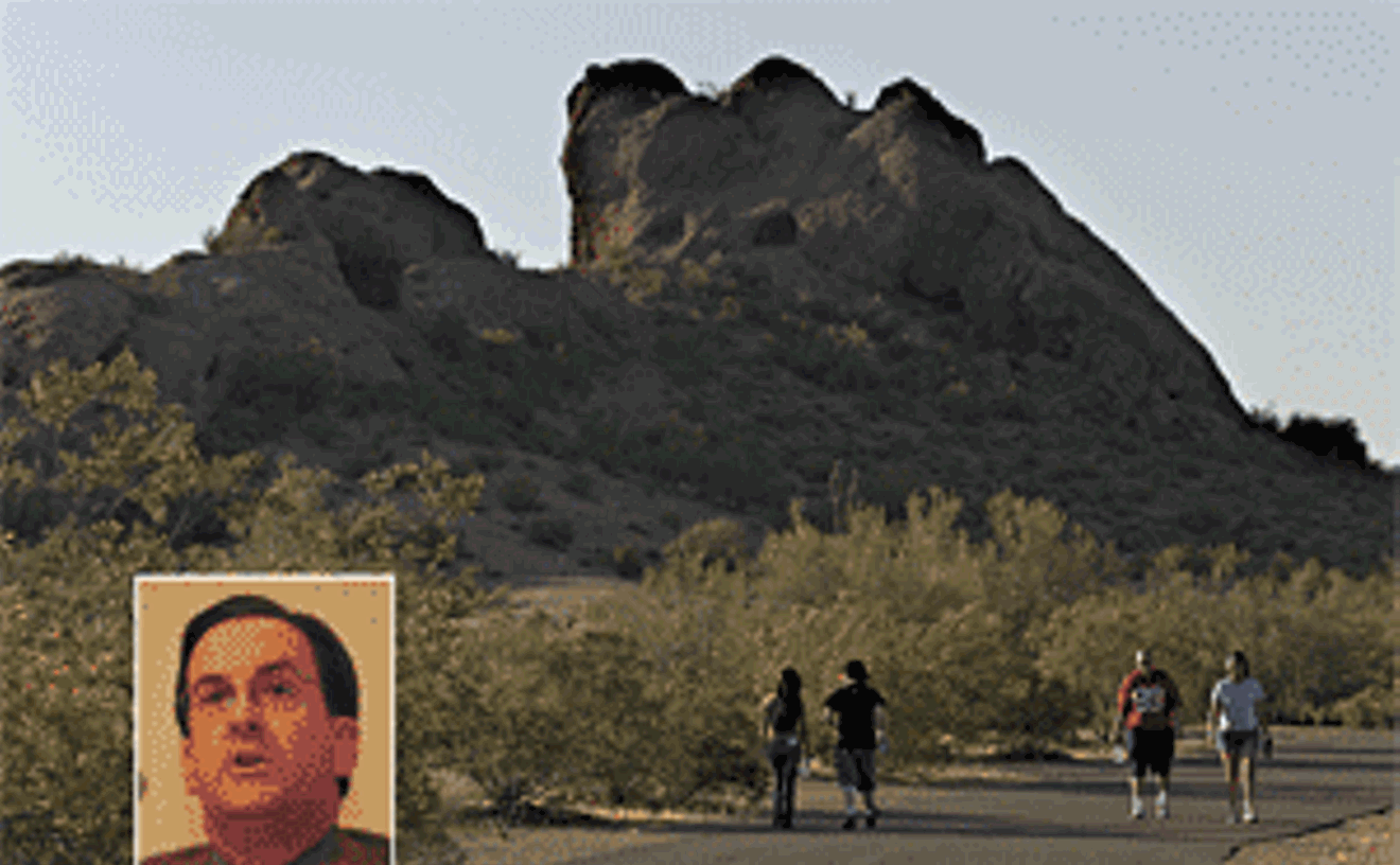
Peter++Scanlon
Attorney+Grady+Gammage+Jr.+%28inset%29+hosted+a+meeting+on+developing+Papago+Park+%28above%29.
Wanna get your tires dusty without blowing out a lung or risking your neck? Try the tame but fun loop trails of Papago Park, centrally located on the borders of Phoenix, Scottsdale, and Tempe. Access the trailheads from the parking lot on the west side of Galvin Parkway, just across from the entrance to the Phoenix Zoo. Begin on the 2.7-mile Elliot Ramada Loop and head toward the buttes. Much of this trail is kid-friendly — rolling, sandy, wide single-track without the need for technical skills. Be sure to intersect with the Double Butte Loop, 2.3 miles, which offers gentle up-and-downs around a butte and past the stone amphitheater visible from McDowell Road. Numerous other trails criss-cross the park, allowing bikers a relaxing cruise through the desert or the chance to try something more challenging.
- 625 N. Galvin Parkway, Phoenix, 85004 Map
- 602-256-3220
- www.phoenix.gov/parks/hikepapa.html
Best Kick-Yer-Butt Mountain Bike Ride
Pass Trail, Usery Mountain Regional Park
This 7.1-mile ride worked us to the bone. A sign near the trailhead states that mountain bikes are not recommended, but that's just to scare off the wimps. True, we had to carry our bike up several tough, rocky sections, which wasn't fun. But most of the trail is passable on a bike, and you'll be rewarded for the extra effort. After sweating the steep stuff to the top, we had several heart-stopping moments coming down sweet single track that clings to the edge of cliffs in places. And we have to mention the incredible view from the top of hundreds of acres of pristine Sonoran Desert in the Tonto National Forest. Though the trail is only seven miles, the challenging terrain takes longer to negotiate — be sure to take more water than you'll think you need, if the weather is warm.
Best Place to Go Rock Climbing
Queen Creek Canyon Area
Granite crags like Pinnacle Peak and the McDowell Mountains make the Valley a rock-climbing mecca, but the area's finest collection of sport-climbing routes is found farther east, near Queen Creek Canyon. Not to be confused with the two-horse town near Higley, the climbers' Queen Creek is the general area four miles north of Superior that includes the Oak Flat Campground, the site of past rock-climbing competitions. You'll need to consult a guidebook to figure out which of the 1,000-plus routes you want to do at places like Euro Dog Valley, Lower Devils Canyon, and the Road Area (which has some of the taller offerings). Favorite spots like the Mine Area are also fun for non-climbers and children, who love to rock-hop and explore the lunar-like terrain. The volcanic rock can be painful on the fingertips, but the sheer number of short climbing routes means there's a lot to love about Queen Creek.
Best Place to Learn Rappeling
Rappel Gully
If you've never walked down a vertical rock face, Rappel Gully is the place to learn. The 75-foot climbing route on the Headwall in Camelback Mountain's Echo Canyon is steep, especially at the top, yet isn't too high to intimidate most beginners. Best of all, the anchor for the rappel is what climbers call "bomb-proof." When you set up ropes for a rappel, it's considered poor form to have the whole setup — and its climber — come spilling down the mountain because of a poor anchor. The anchor at the top of Rappel Gully is a massive eyebolt set deep into the rock and secured with concrete. It's not going anywhere. And it's hard to mess up the rope work here — you simply feed one end of the rope through the circle of metal and you're ready to go. That first step off the edge is always the most unnerving for beginners, who often aren't sure if they're going to survive. Another great perk: The west-facing Rappel Gully is in the shade all morning.
Best Free-Solo Rock Climb
Headwall
"Now that's extreme!" a young Camelback Mountain hiker shouted to his buddies as he watched us free-solo climb up a cliff. Now, we don't free-solo — which means rock-climbing without the aid of ropes or a partner — to hear such accolades. But it made us feel damned cool, even though the cliff we were on wasn't really extreme, by the standards of experienced rock climbers. We're not experts (never climbed El Capitan or spent the night on a "porta-ledge"), but we've attained a skill level that allows us to free-solo comfortably on some climbing routes. The cliff at Camelback that psyched the onlooker is one such route. It's the north-facing corner near the top of the first saddle on the Echo Canyon trail. The cliff is just one way to the top of the Headwall climbing area, which includes the popular Rappel Gully route (see "Best Place to Learn Rappeling") a few yards south. While many climbers rope up for this section, we've seen just as many "free" it, as we typically do. Needless to say, this kind of activity can be dangerous — even death-defying. But it's also liberating and focuses your mind like nothing else. Just watch out for loose rock and remember the number-one rule of free-soloing: It's all up to you.
Best Of Phoenix®
-
La Vida
-
Best Calle of Dreams
"Calle 16: A Mural Project" in the "office" at Barrio Cafe
-
Best New Showcase for Latino Art
Arizona Latino Arts and Cultural Center/Galeria 147
-
Best Pinata Art
Mutant Pinata Show at Bragg's Pie Factory
-
Best Pinata Politics
Scott Jacobson
-
Best Day of the Dead Festival
Desert Botanical Garden
-
Best Mexican Imports
Mercado Mexico
-
Best Boutique with a Mexican Flair
Purple Lizard
-
Best Mexican Embroidery Supplies
Mario Ramos Mexican Imports
-
Best Place to Take a Tourist Looking for Mexican Tchotchkes
Mexican Import
-
Best Mexican Market
Food City
-
Best Latin Brunch
The Mission
-
Best Upscale Mexican Restaurant
La Hacienda
-
Best Neighborhood Mexican Restaurant, Central Phoenix
La Tolteca
-
Best Neighborhood Mexican Restaurant, South Phoenix
Los Dos Molinos
-
Best Neighborhood Mexican Restaurant, West Valley
Pepe's Taco Villa
-
Best Neighborhood Mexican Restaurant, Southeast Valley
Si Senor
-
Best Neighborhood Mexican Restaurant, Tempe
Moreno's Mexican Grill
-
Best Neighborhood Mexican Restaurant, Scottsdale
Habanero's Mexican Grill
-
Best Mexican Restaurant Decor con Queso
Casa Reynoso
-
Best Salsa
Kissed With Fire
-
Best Tortillas
Verde
-
Best Huitlacoche
Los Sombreros
-
Best Tortas
Gallo Blanco Cafe & Bar
-
Best Sonoran Hot Dog
Nogales Hot Dogs
-
Best Tamales
The Tamale Store
-
Best Carne Asada
Sonora Mesquite Grill
-
Best Carne Adovada
Dick's Hideaway
-
Best Cochinita Pibil
Barrio Cafe
-
Best Tacos
La Condesa Gourmet Taco Shop
-
Best Burrito
Rito's Mexican Food
-
Best Mariscos
Mariscos Playa Hermosa
-
Best Tapas
Iruna
-
Best Flan
Secreto
-
Best Paletas
Paletas Betty
-
Best Mexican Candy Store
Dulceria Pico Rico
-
Best Margarita Mix
Margarita Sensations
-
Best Tequila
3 Amigos Tequila
-
Best Margarita
SideBar
-
Best Cucumber Margarita
Cruz Tequila's Cucumber Margarita
-
Best Chambord Margarita
Z'Tejas
-
Best Latin Club
Sky Lounge
-
Best Latin Dance Night
Saturdays at DWNTWN
-
Best Gay Latin Dance Night
Kaliente Saturdays
-
Best Latin DJ
DJ Kyko
-
Best Place to Watch Lucha Libre in Action
Gladiadores Unidos, Fridays, 7 p.m.
-
Best Place to Get a Spider-Man Piñata
Mundo Piñata
-
Best Immigrant's Comic Book
The Guide for the Mexican Migrant
-
Hero Worship
Santiago Gonzalez
-
-
Food & Drink
-
Best New Restaurant
FnB
-
Best Old Arizona Charm
The Stockyards Restaurant
-
Best Competitive Eating Splurge
Durant's
-
Best Competitive Eating Bargain
San Felipe's Cantina
-
Best Hot Dog
The Main Ingredient
-
Best Wings
Teakwoods
-
Best Fish 'n' Chips
Rúla Búla
-
Best Burger
The Grind
-
Best Fries
Metro Brasserie
-
Best Dim Sum
Phoenix Palace
-
Best Noodles
China Magic Noodle House
-
Best Sushi
Hana Japanese Eatery
-
Best Budget Sushi
Teharu Sushi
-
Best Foie Gras
Christopher's
-
Best Seafood
Noca
-
Best Sandwiches
Pane Bianco
-
Best Jewish Deli
Stan's Metro Deli
-
Best Fast Food
Maui Dog
-
Best Fried Chicken
Caffe Boa
-
Best Pulled Pork
Joe's Real BBQ
-
Best Pig Roast
McReynolds Farms Inc.
-
Best Brisket
Bryan's Black Mountain Barbecue
-
Best BBQ Sauce
Honey Bear's
-
Best Soul Food Restaurant
Mrs. White's Golden Rule Cafe
-
Best Contemporary American Restaurant
Quiessence
-
Best Upscale Italian Restaurant
Marcellino Ristorante
-
Best Corner Italian Restaurant
Andreoli Italian Grocer
-
Best Upscale Steakhouse
BLT Steak
-
Best Old-School Steak House
Durant's
-
Best French Restaurant
Zinc Bistro
-
Best Puerto Rican
El Coquito
-
Best Indian Restaurant
Guru Palace
-
Best Middle Eastern Restaurant
Al-Hana Restaurant
-
Best Korean Restaurant
Restaurant Takamatsu
-
Best Japanese Restaurant
Sushi Ken
-
Best Vietnamese Restaurant
Da Vang
-
Best Chinese Restaurant
Asian Cafe Express
-
Best Thai Restaurant
Thai E-San
-
Best Vegan Restaurant
Chakra 4 Herb & Tea House
-
Best Vegetarian Restaurant
Cafe Krishna
-
Best Gourmet Pizza
Pizzeria Bianco
-
Best Slice of Pizza
Jimmy & Joe's
-
Best Neighborhood Pizzeria, Central Phoenix
Cibo
-
Best Neighborhood Pizzeria, South Phoenix
Amano Bistro
-
Best Neighborhood Pizzeria, West Valley
La Piazza al Forno
-
Best Neighborhood Pizzeria, Southeast Valley
Nello's
-
Best Neighborhood Pizzeria, Scottsdale
Humble Pie
-
Best Neighborhood Pizzeria, Tempe
Classic Italian Pizza
-
Best Sign of Urban Renewal
Nobuo at Teeter House
-
Best Place to Take a Foodie
Binkley's
-
Best Place to Take a Scenester
St. Francis
-
Best Place to Buy Cheese Curds
Milk 'n' More Store
-
Best Food Truck
Truckin' Good Food
-
Best Organic Produce
McClendon's Select
-
Best Food Co-Op
Bountiful Baskets
-
Best New Farmers Market, West Valley
Momma's Organic Market at Park West
-
Best New Farmers Market, East Valley
Thursday Night Market at Hayden Station Plaza
-
Best Farmers Market for a Sweet Tooth
Ahwatukee Farmers Market
-
Best Farmers Market for Fido
Scottsdale Old Town Farmers Market
-
Best Patio Dining
Frank & Albert's
-
Best Sunday Brunch
Lon's at the Hermosa
-
Best Breakfast, Central Phoenix
Matt's Big Breakfast
-
Best Breakfast, South Phoenix
Lo-Lo's Chicken & Waffles
-
Best Breakfast, West Valley
Cee Cee's on the Corner
-
Best Breakfast, Southeast Valley
Liberty Market
-
Best Breakfast, Tempe
Crackers & Co. Cafe
-
Best Breakfast, Scottsdale
Orange Table
-
Best Hidden Gem
Crudo
-
Best Bar Food
The Roosevelt
-
Best BYOB
Atlas Bistro
-
Best BYOB
Atlas Bistro
-
Best Dining as Theater
Le Chalet
-
Best Place to Eat at the Counter
Posh Improvisational Cuisine
-
Best Wine Bar
Postino Winecafé
-
Best Place to Take a First Date
The Parlor
-
Best View
J&G Steakhouse
-
Best Hot Spot
Modern Steak
-
Best Hummus
Dr. Hummus
-
Best Sausage
Schreiner's Fine Sausages
-
Best Kimchee
Paldo Market
-
Best Use of Bacon
Bacon Brownies
-
Best Use of Veal
House of Tricks' Veal Bacon
-
Best Use of Prunes
Prune Danish
-
Best Kalamata Olive Bread
Jonathan Robins Bakery
-
Best Pork Chili Verde
Ranch House Grille
-
Best Salad Topping
Yulu Seeds
-
Best Butter
Creative Butters
-
Best Bakery
Karl's Quality Bakery
-
Best Cupcake
Black and White Cupcake at Copper Star Coffee
-
Best Cheesecake
Bertha's Caf�
-
Best Cookies
Sid's Viciously Good Cookies
-
Best Marshmallows
Tracy Dempsey Originals
-
Best Toffee
Goody Twos
-
Best Chocolate
ib2 Chocolates
-
Best Pie
Pie Snob
-
Best Chocolate Egg Cream
Scott's Generations
-
Best Banana Shake
Chicago Hamburger Company
-
Best Frozen Yogurt
Oatmeal Cookie at Yogurtology
-
Best Ice Cream
Sweet Republic
-
Best Ice Cream with a Kick
Lee's Cream Liqueur
-
Best Room Service at Home
Delicious Deliveries
-
Best Bite at the Mall
The Greene House
-
Best Restaurant for Kids
Mining Camp Restaurant
-
Best Afternoon Tea
The Ritz-Carlton
-
Best Place to Meet a Celebrity Chef
elements
-
Best New Eatery Along the Light Rail
Mid City Kitchen
-
Best Romantic Dinner
T. Cook's
-
Best Late-Night Nosh
Petite Maison
-
Best Destination Dining
Kai
-
Best Makeover
El Chorro Lodge
-
Best Spin-Off
Cafe Bink
-
Best Encore
The Vig Uptown
-
Best Place for a Stomach of Steel
Tacos Jalisco
-
Best Gyro
Dino's Greek and Italian
-
Best Way to Eat Your Spinach
California Spinach Salad, at Maizie's Café & Bistro
-
Best Super-Food
Arnie's Health Foods
-
Best Hero Sandwich
Venezia's Pizzeria
-
Hero Worship
Nobuo Fukuda
-
-
Bars & Clubs
-
Best Karaoke with a Live Band
"I'm with the Band" on Mondays at Blue Martini Lounge
-
Best New Club
Revolver Lounge
-
Best New-School Martini
Sens
-
Best Old-School Martini
Seamus McCaffrey's
-
Best Bloody Mary
Carly's Bistro
-
Best Red Sangria
Rita's Kitchen at Camelback Inn
-
Best White Sangria
La Bocca Urban Pizzeria & Wine Bar
-
Best Frozen Sangria
Caffe Italia
-
Best Mojito
MercBar
-
Best Manhattan
Roadrunner Lounge
-
Best Lounge
T. Cook's at The Royal Palms
-
Best Bottled Beer Selection
Taste of Tops
-
Best Local Beer for a Novice Drinker
Papago Brewing Company's Orange Blossom
-
Best Local Seasonal Beer
Winter Warmer
-
Best Place to Drink Pabst Blue Ribbon
Old Skool 50 Cent PBR Night
-
Best Wine on a Budget
Postino Winecaf�
-
Best Happy Hour, Central Phoenix
Fez Restaurant and Urban Bar
-
Best Happy Hour, South Phoenix
Amano Pizza Bistro
-
Best Happy Hour, Downtown Phoenix
District
-
Best Happy Hour, West Valley
Tuscan Oven
-
Best Happy Hour, Southeast Valley
San Tan Brewing Company
-
Best Happy Hour, Tempe
Four Peaks Brewing Company
-
Best Place for a Twilight Drink
House of Tricks
-
Best Bar for Day Drinking
The Recovery Room
-
Best Dive Bar
Wanderin
-
Best Bar for a Drink and a Smoke
Maverick Saloon
-
Best Bar for Bikers and Hipsters
Chopper John's
-
Best Smoking Patio
Amsterdam
-
Best Hookah Lounge
Caf� Istanbul and Market
-
Best Old Hipster DJ
Shane Kennedy
-
Best Young Hipster DJ
Hartbreaks
-
Best Hip-Hop Night
The Blunt Club, Thursdays at Yucca Tap Room
-
Best Drag Queen Show
"The Follies" at Ice Pics
-
Best Gay Bar
Bar 1
-
Best Lesbian Bar
Cash Inn Country
-
Best Ladies Night
Roka Akor
-
Best Ladies Fight
Stripper Fight League at Cheetahs Gentleman's Club
-
Best Bartender
Philthy Phil
-
Best Place to See Midget Bartenders
Giligin's Bar
-
Best Sports Bar, Central Phoenix
The Ox Sports Bar
-
Best Sports Bar, Downtown Phoenix
Coach & Willie's
-
Best Sports Bar, South Phoenix
Gallagher's Sports Grill
-
Best Sports Bar, North Phoenix
16th Street Sports Bar
-
Best Sports Bar, West Valley
Yard House
-
Best Sports Bar, Southeast Valley
Crabby Don's Bar & Restaurant
-
Best Sports Bar, Tempe
Baseline Sports Bar
-
Best Sports Bar, Scottsdale
American Junkie
-
Best Pool Hall
BullShooters
-
Best Bar Trivia Night
Doc & Eddy's
-
Best Pub
Robbie Fox's Public House
-
Best Neighborhood Bar, Central Phoenix
JT's Bar & Grill
-
Best Neighborhood Bar, Downtown Phoenix
SideBar
-
Best Neighborhood Bar, South Phoenix
Mother's Bar & Grill
-
Best Neighborhood Bar, North Phoenix
Steel Horse Saloon
-
Best Neighborhood Bar, West Valley
Exit 7 Bar & Grill
-
Best Neighborhood Bar, Southeast Valley
Buffalo Wings & Rings
-
Best Neighborhood Bar, Tempe
Boulders on Broadway
-
Best Neighborhood Bar, Scottsdale
TT Roadhouse
-
Best Legacy Bar
Long Wong's at the Firehouse
-
Best Comeback
Nile Theatre/theUnderground
-
Best Place to Await the Second Coming
Padre Murphy's
-
Best Place to Reenact Saturday Night Fever
Disco
-
Best Place to Practice for American Idol
Lucky Break at Lone Butte Casino
-
Best Karaoke
Hazelwoods First Place Sports Grill
-
Best Box Karaoke
Korean BBQ
-
Best Country & Western Nightclub
Rusty Spur Saloon
-
Best Country & Western Bar
The Buffalo Chip Saloon & Steakhouse
-
Best Rockabilly Bar
Rogue West
-
Best Rock Club
The Sail Inn
-
Best Place to See a Metal Show
UB's Restaurant & Bar
-
Best Cover Band
Bad Sneakers
-
Best Place to Watch Tribute Bands
Skye
-
Best Arena Show
Paul McCartney at Jobing.com Arena
-
Best Theater Show
Jeff Tweedy at The Orpheum
-
Best Club Show
Sergio Mendoza y la Orkesta at Sail Inn
-
Best All-Ages Show
Titus Andronicus at Chyro Arts
-
Best Place to Catch a House Show
Ye Olde Bike Saviours
-
Best Place to Get Up Close and Personal with the Band
Palo Verde Lounge
-
Best Place to Find an Underground Hardcore Show
The Slurp
-
Best Underground Dance Night
602'sdays at Bikini Lounge
-
Best Dance Night
Ransom: Fridays at Philthy Phil's
-
Best To-Go Beer
The Lost Leaf
-
Best After-Hours
The Quincy
-
Best Hangover Breakfast
Harlow's Caf�
-
Best Rehab
The Meadows of Wickenburg
-
Best Liquid Courage
Three Wise Men shot at Rips
-
Best Hideout
Kat's
-
Best Nightclub Costumed Crusaders
Rock&RollDancePatrol
-
Best Costume Parties
Afterlife
-
Best Juggalo
DieNasty of Dark Side Immortals
-
Hero Worship
Shaun Moss
-
-
People & Places
-
Best Art in a Cigarette Machine
The Art-o-mat Machine, at Vision Gallery
-
Best Way to Get Around Old Town Scottsdale
Bunny Rides Golf Carts
-
Best Humbling Fact
Phoenix is short.
-
Best Phoenix History Lesson
Phoenix Retro Spectacular at Phoenix Metro Retro
-
Best Photo Opportunity
Mr. Fun Booth
-
Best People Watching
Arizona State Fair
-
Best Block Party
Main Street art walk, second Fridays of every month
-
Best Restaurant Tour
Scottsdale Food Tour
-
Best Culinary Festival
Devoured Phoenix Culinary Classic, at the Phoenix Art Museum
-
Best Beer Festival
Arizona Strong Beer Festival
-
Best Music Festival
Vans Warped Tour
-
Best Cultural Festival
Matsuri
-
Best Indie Craft Festival
Indie Crafeteria
-
Best Arts Festival
Scottsdale Arts Festival
-
Best Way to Experience First Fridays
The Red Dress Tours (Caminando de Rojo)
-
Best Stop on Art Detour
Westwind Studios
-
Best Recession Art
5 & 6 Fine Art Space
-
Best Outsider Art
Unsung Gallery
-
Best Do-Good Art Program
"Arts Engagement"
-
Best Art School
Anti-Art School, at The Lost Leaf
-
Best Cardboard Art
Cartel Coffee Lab
-
Best Art in a Vending Machine
Spencer Hibert's Mini Miigii
-
Best Postcards
Irma Sanchez
-
Best Public Art
Louise Bourgeois' Art Is a Guaranty of Sanity
-
Best Place to See Photography
Bokeh Gallery
-
Best Gallery to See Artists Both Famous and Amateur Hanging Side by Side
The Trunk Space
-
Best Revolving Public Art
Seventh Avenue Streetscape Panels
-
Best Rotating Murals
eye lounge
-
Best Extreme Makeover
Modified Arts
-
Best New Museum
The Musical Instrument Museum
-
Best Children's Museum
Arizona Museum for Youth
-
Best Chance to Revitalize Downtown Phoenix
Cityscape
-
Best Sign of Nightlife in Downtown Phoenix
District Restaurant
-
Best Downtown Building to Poke Your Head Into
Lois Grunow Memorial Clinic
-
Best Urban Legend
Downtown's Abandoned Underground Bowling Alley
-
Best-Hidden Super-Secret Museum
Phoenix Union High memorabilia
-
Best Airport Terminal
Terminal 2
-
Best Roaring Fire
Tempe Marketplace
-
Best Puddle
Tempe Town Lake
-
Best Shower
Dick's Hideaway
-
Best Bathroom
Modern Steak
-
Best Home Show
Maricopa County Home Shows
-
Best Home Tour
Willo Historic Neighborhood Home Tour
-
Best Neighborhood
Encanto/Palmcroft
-
Best Drive
Central Avenue between Camelback and Northern
-
Best Street
16th Street, between Van Buren Street and Indian School Road
-
Best Dream
Canalscape
-
Best Street of Dreams Come True
Fifth Street, between Roosevelt and Garfield
-
Best Street of Dreams
Sixth Street, between Roosevelt and Garfield
-
Best Retail Vision, Realized
The Duce
-
Best Retail Vision
POOL Together
-
Best Unexpected Urbanity
Historic Glendale
-
Best Library
Scottsdale Civic Center
-
Best Strip Mall
Southwest corner of Ash Avenue and University Drive, Tempe
-
Best Boutique Hotel
The Clarendon
-
Best Luxury Hotel
Sanctuary Camelback Mountain
-
Best Spa
The Golden Door Spa at The Boulders Resort
-
Best Style Blog
SeeSaw Designs
-
Best Indie Music Blog
Electric Mustache
-
Best Food Blog
Lunch Bucket Bento
-
Best Urban Planning Blog
Blooming Rock
-
Best Shopping Blog
The Willows
-
Best Local Wedding Resource
Arizona Weddings magazine and website
-
Best Light-Rail Resource
Rail Life
-
Best Use of Social Media to Promote Semi-Nudity
Second Annual No Pants Light Rail Ride
-
Best Web Comic
Monster Commute
-
Best Fiction Web Show
Probed Signals
-
Best Public Affairs Web Show
CenPho.TV
-
Best Twitterer
Former Arizona Attorney General Grant Woods
-
Best Hangout for Anarchists, Revolutionaries, and Dreamers
Conspire
-
Best Hangout for Lefties
Fair Trade Café
-
Best Way to Hang Out with Republicans
Politics on the Rocks
-
Best Politician
Jan Brewer
-
Best Power Couple
Phil Gordon and Elissa Mullany
-
Best Public Information Officer
Vinnie Picard
-
Best Government Customer Service
Phoenix City Clerk Department
-
Best Psychic Detective Group
Find Me
-
Best Local Skeptic
Michael Stackpole
-
Best TV Journalists
Morgan Loew and Gilbert Zermeno
-
Best News Radio Station
KTAR 92.3 FM (sans Darrell Ankarlo)
-
Best Syndicated Sports Radio Show
The Herd with Colin Cowherd
-
Best Local Sports Radio Show
Bickley and MJ
-
Best Rock Radio Personality
Robin Nash, X 103.9 FM
-
Best Hip-Hop Radio Personality
Chris Chavez, Power 98.3 FM
-
Best Hip-Hop Radio Station
The Beat 92.7 FM and 99.3 FM
-
Best Country Radio Personality
Barrel Boy, KNIX 102.5 FM
-
Best Country Radio Station
KSWG 96.3 FM
-
Best Sound Guy
Mike Toth
-
Best Concert Fliers
The Surfside IV
-
Best Entertainment on the Light Rail
The Train Tracks
-
Best Local Compilation CD
Zia Records' You Heard Us Back When . . .
-
Best Punk Moment
Die Ignorant hosts a car wash at Applebee's
-
Best Jazz Music Series
"Jazz in the Garden"
-
Best Classical Music Series
Arizona Bach Festival
-
Best Contemporary Dance Company
Scorpius Dance Theatre
-
Best Funky Arts Space in Town That Never Changes
Kerr Cultural Center
-
Best Community Theater
Stray Cat Theatre, at Tempe Performing Arts Center
-
Best Equity House
Arizona Theatre Company
-
Best Actress
Katie McFadzen
-
Best Actor
Steven Scally in Indivisible
-
Best Coffee House to Run Into Local Actors
Urban Beans
-
Best Curtain Speech
Damon Dering, Nearly Naked Theatre
-
Best Children's Theater
Childsplay, at Tempe Center for the Arts
-
Best Theater Venue
The Herberger Theater Center
-
Best Repertory Movie House
Madcap Theaters
-
Best Microcinema
No Festival Required
-
Best Budget Movie Night
Sci-Fi Movie Night at The Paisley Violin
-
Best Movie Tickets
Valley Movie Group
-
Best Drive-In Movie Theater
West Wind Scottsdale 6 Drive-In
-
Best Backyard Cinema
Phoenix Independent, Foreign and Art House Film Club
-
Best Portrayal of a Lowlife on Film
Phoenix actor Luis Avila in 7 Soles
-
Best Costuming Group
Arizona Costumed Revelers
-
Best Costumed Event
The "Brides of March" pub crawl
-
Best Face Painting
Anna Banana Face Painting
-
Best Sci-Fi Convention
LepreCon
-
Best Anime Convention
Saboten-Con
-
Best Game
The Citadel
-
Best Book Club
Downtown Phoenix Book Club
-
Best Way to Learn About the Harvey Girls
Arizona Capitol Museum Exhibit
-
Best Place to Learn How to Rescue a Raptor
Liberty Wildlife
-
Best Way to a Homeless Pet Without a Long-Term Commitment
The Foster Care Program at the Arizona Humane Society
-
Best Bar Cat
Thomas, at Casey Moore's Oyster House
-
Best Happy Hour Resource for Cougar Hunters
www.cougarsandco.com
-
Best 'Zine
PoolBoy
-
Best Roaring Fire
Tempe Marketplace
-
Best Cab Company If You Wanna Be Clean
Clean Air Cab
-
Best Unbeaten Path to San Diego
State Highway 238
-
Best Vintage Local Superhero
Captain Super
-
Best Local Erotic Comic
Demi the Demoness
-
Best Superhero Training Ground
"Superheroes and American Culture" by Diane Facinelli
-
Best Comic Convention
Phoenix Comicon
-
Best Political Kryptonite
Meghan McCain
-
Best Place to See Action Figures
Arizona Pop Culture Museum
-
Best Local Comic Store to Appear in a Major Motion Picture
Atomic Comics in Kick-Ass
-
Best Bat Cave
Phoenix Bat Cave
-
Best Alter Ego
Ben Quayle (a.k.a. Brock Landers)
-
Hero Worship
Angela Ellsworth
-
Hero Worship
Bob Hoag
-
Hero Worship
Sam
-
-
Shopping & Services
-
Best New Shop
Sweets & Beats
-
Best Retail Co-Op
Paisley Town
-
Best Boutique
Frances
-
Best Move
Bunky Boutique
-
Best Roommates
Olive in Paris and Paris Envy
-
Best Shopping on Grand Avenue
Kooky Krafts
-
Best Shopping on Roosevelt Row
MADE art boutique
-
Best Place to Find Local Fashion
Local Talent
-
Best Mid-Century Everything
Retro Ranch
-
Best Robots
Red Hot Robot
-
Best Subversive
Sebastien Millon
-
Best T-Shirts as Greeting Cards
Brand X
-
Best Alternative to Sending Flowers
Fairytale Brownies
-
Best Florist
Community Florist
-
Best Independent Nursery
Baker Nursery
-
Best Chain Nursery
Lowe's
-
Best Outdoor Furniture
Zinnias at Melrose
-
Best Home and Garden Shop
Figs Home & Garden
-
Best Hostess Gifts
La Grande Orange Grocery
-
Best High-End Hostess Gifts on the Cheap
Stupid Cupid Gifts
-
Best Antiques on a Budget
Cheap Thrills
-
Best Boutique Thrift Store
Ozzie's Furnishings
-
Best Non-Boutique Thrift Store
Goodwill
-
Best Thrift Store for Small Appliances
Flo's on Seventh
-
Best Seasonal Clearance Aisle
Hobby Lobby
-
Best Thrift Store for Amateur Paintings
Savers
-
Best Thrift Store for Square Dancing Costumes
Travel Thru Time
-
Best Place to Get Creative on the Cheap
Tempe Sales
-
Best Art Supplies
Wet Paint Artist Supply
-
Best Scrapbook Supplies
Scrapbook Barn
-
Best Stamp Supplies
Stamp Works
-
Best Soap-Making Supplies
Janca's Jojoba Oil & Seed Co
-
Best Bead Store
Confetti: The Bead Place
-
Best Knitting Supplies
Arizona Knitting & Needlepoint
-
Best Felt
Knit Happens
-
Best Fabric Store
SAS Fabric by the Pound
-
Best High-End Fabric Store
Danese Creations
-
Best High-End Bed and Bath Shop
Valerianne of Scottsdale
-
Best High-End Antiques
Willo Antiques
-
Best Antique Rugs
The Rug Room at Antique Gatherings
-
Best Vintage Haute Couture
Fashion by Robert Black
-
Best Used Clothing for Kids
Love Child
-
Best Kid Consignment Sales
Kid's Closet Connection
-
Best Shopping on a College Girl's Budget
Here on the Corner
-
Best Bargain Clothing
Last Chance
-
Best Bargain on Vintage Clothing
Hollywood Regency Vintage
-
Best High-End Boutique for Kids
Garage
-
Best Vintage Clothing
Butter Toast Boutique
-
Best Vintage Jeans
The Blue Jean Buyer
-
Best Place to Unload Your VHS Tapes for Credit
Bookmans
-
Best Used Bookstore
Book Gallery
-
Best Budget Bookstore
Half Price Books
-
Best Collectible Bookstore
Charles Parkhurst Rare Books
-
Best Bookstore
Changing Hands Bookstore
-
Best Comfortable Shoes
Shoe Mill
-
Best Shoeshine
Jacques Brice
-
Best Car Wash
Los Olivos Car Wash
-
Best Place to Give Your Dog a Bath
Wag N' Wash
-
Best Pet Boutique
Shauna's Paw Spa & Pet Boutique
-
Best Bike Shop
Tempe Bicycle
-
Best Skateboard Shop
Cowtown Skateboards
-
Best Knife Shop
Phoenix Knife House
-
Best Multicultural Shopping Experience
The House of Rice Store
-
Best Japanese Market
New Tokyo Food Market
-
Best Oil and Vinegar
Queen Creek Olive Mill
-
Best Spice Shop
Sahuaro Spice Company
-
Best Place to Buy Bulk Herbs
SW Herb Shop and Gathering Place
-
Best Cooking Supplies
Shar's Bosch Kitchen Center
-
Best Baking Supplies
ABC Cake Decorating Supplies
-
Best Candy Store
Smeeks
-
Best Coffee House, Central Phoenix
Lux Coffeebar
-
Best Coffee House, Downtown Phoenix
Lola Coffee
-
Best Coffee House, North Phoenix
Fiddler's Dream Coffeehouse
-
Best Coffee House, West Valley
The Bad Ass Coffee Co.
-
Best Coffee House, Southeast Valley
Coffee Rush
-
Best Coffee House, Mesa
Inside the Bungalow
-
Best Coffee House, Tempe
Cartel Coffee Lab
-
Best Coffee House, Scottsdale
Sola Coffee Bar
-
Best Cigar Shop
Ye Olde Pipe & Tobacco Shoppe
-
Best Head Shop
Traders Smoke Shop
-
Best Home Brewing Supplies
Brew Your Own Brew
-
Best Place to Bottle Your Own Wine
Su Vino Winery
-
Best Drive-Thru Liquor Store
Tower Liquors
-
Best S&M Supplies
Smokin' Lingerie
-
Best Leather
Tuff Stuff Leather
-
Best Vinyl
Revolver Records
-
Best Place to Buy CDs
Hoodlums Music and Movies
-
Best Place for Dubbing
Lambchops Studios
-
Best Vintage Guitars
Bizarre Guitar & Drum
-
Best Place to Get Metaphysical
The Astrology Store
-
Best Way to Avoid Getting Yourself on an Episode of Hoarders
Arc of Tempe Thrift Store
-
Best Place to Get Superhero Costumes
Easley's Costumes & Fun Shop
-
Best Comic Book Superstore
Atomic Comics
-
Best Place to Buy an Action Figure
McFarlane
-
Best Cosplay Supplies
Samurai Comics
-
Best Spy Equipment
Spy Headquarters
-
Best Place to Buy Spandex Tights
Dee's Dancewear
-
Best Place to Outfit Yourself Like a Warrior
Windrose Armoury
-
Best Shopping on the Dark Side
Evermore Nevermore
-
Best Place to Pimp Your Ride, Batman-Style
The Armored Group
-
Best Cab Company If You Wanna Get Dirty
Sunrise Cab
-
Hero Worship
Beatrice Moore
-
-
Sports & Recreation
-
Best Hike You'll Never Do
Red Mountain (a.k.a. Mount McDowell)
-
Best Adventure Hike
Four Peaks after a snowstorm
-
Best Night Hike
South Mountain Pima Canyon
-
Best Grand Canyon Training Hike
Phoenix Mountains Recreation Area/Piestewa Peak
-
Best Wildflower Hike
Usery Mountain Regional Park, Pass Mountain Loop
-
Best Petroglyph Hike
Kiwanis Trail, South Mountain
-
Best Wheelchair Hike
West Park Accessible Trail at Papago Park
-
Best Dog Hike
Shaw Butte, Trail 306
-
Best Dog Park, West Valley
PetSmart Dog Park at Washington Park
-
Best Dog Park, East Valley
Cosmo Dog Park
-
Best Outdoor Playground
Hudson Park
-
Best Indoor Playground
Makutu's Island
-
Best Place for Kids to Bounce
Pump It Up
-
Best Place for Adults to Bounce
jumpstreet
-
Best Outdoor Haunted House
Fear Farm
-
Best Indoor Haunted House
The Gauntlet at Golfland Sunsplash
-
Best Physically Fit Show of Christmas Spirit
Mountaintop decorations
-
Best Place to Live Out Your Eva Peron Fantasies
New Year's Weekend Arabian Farm Tour
-
Best Place to Learn to Pole Dance
Express MiE Dance Fitness and Pole Dancing Studio
-
Best Place to Drink While Your Kid Plays Hockey
Alltel Ice Den
-
Best Place to Get Your Game On
Gamers' Inn
-
Best Indoor Shooting Range
Caswells Shooting Range
-
Best Junior Marksmen Program
Rio Salado Sportsman's Club
-
Best Outdoor Shooting Range
Ben Avery Shooting Facility
-
Best Place to Go Dove Hunting
Fields around Stanfield, Arizona
-
Best Place to Access the Superstition Mountains If Lost Dutchman Park Closes (Or Even If It Doesn't)
First Water Trailhead
-
Best Mine Tour
Goldfield Ghost Town
-
Best Activity for Out-of-Town Guests
Dolly Steamboat Tours
-
Best Lake Camping
Apache Lake
-
Best Swimming Hole
The Water Wheel, in Tonto National Forest
-
Best Urban Kayaking
Tempe Town Lake
-
Best Water Park
Oasis Water Park at the Arizona Grand Resort
-
Best Skateboard Park
Goodyear Skate Park
-
Best Place to Go Off-Roading
Sycamore Creek
-
Best Motorcycle Gang
The Scooter Club of Metro Phoenix
-
Best Go-Kart Racing
F1 Race Factory
-
Best Bowling
Squaw Peak Lanes
-
Best Miniature Golf
Jambo! Indoor Amusement Park
-
Best Free Driving Range
The train tracks west of Casey Moore's, Tempe
-
Best Driving Range
Fiddlesticks Family Fun Park
-
Best Golf Cart
Kierland Golf Club
-
Best Summer Golf Course
TPC Scottsdale
-
Best Winter Golf Course
Ken McDonald Golf Course
-
Best Golf Hole
10th Hole, Pointe Golf Course on Lookout Mountain
-
Best Golf Hole for Your Ego
11th hole at Ken McDonald Golf Course
-
Best Place to Find Inspiration While Jogging
ASU Running Track, Student Recreation Complex
-
Best Canal to Walk, Run or Bike, Phoenix
Highline Canal
-
Best Canal to Run, Walk, or Bike, Scottsdale
Arizona Canal
-
Best Road Bike Ride
Central Phoenix to Scottsdale/Tempe via Oak Street
-
Best Easy Mountain Bike Ride
Papago Park
-
Best Kick-Yer-Butt Mountain Bike Ride
Pass Trail, Usery Mountain Regional Park
-
Best Place to Go Rock Climbing
Queen Creek Canyon Area
-
Best Place to Learn Rappeling
Rappel Gully
-
Best Free-Solo Rock Climb
Headwall
-
Best Indoor Rock Climbing
The Phoenix Rock Gym
-
Best Indoor Pickup Basketball
Valley of the Sun Jewish Community Center
-
Best Outdoor Pickup Basketball
Chaparral Park
-
Best Tennis Courts
Kiwanis Park Recreation Center
-
Best Batting Cage
Kiwanis Park Recreation Center
-
Best Place to See a Spring Training Game
Goodyear Ballpark
-
Best High School Athlete
Corey Hawkins
-
Best College Coach
Herb Sendek
-
Best Men's College Team
Arizona State University baseball
-
Best Women's College Team
South Mountain Community College Softball
-
Best Baseball Star
Arizona Diamondbacks right fielder Justin Upton
-
Best Comeback Story in Baseball
Arizona Diamondbacks center fielder Chris Young
-
Best Whiffer (Again, Dammit)
Arizona Diamondbacks third baseman Mark Reynolds
-
Best Cool-Looking (Interim) Manager in the Majors
Arizona Diamondbacks' Kirk Gibson
-
Best Reason to Believe the D-Backs Can Pull Themselves Up to at Least Mediocre Next Season
The firing of general manager Josh Byrnes and manager A.J. Hinch
-
Best All-Around Diamondbacks Player
Catcher Miguel Montero
-
Best Disappearing Act in Valley Sports
Arizona Diamondbacks pitcher Brandon Webb
-
Best Sports Babe
Danica Patrick
-
Best Classy Player in Professional Sports
Phoenix Suns point guard Steve Nash
-
Best Hope for the Suns to Go Far in the Playoffs
Center Robin Lopez
-
Best Professional Sports Executive
Phoenix Suns owner Robert Sarver
-
Best New Addition to the Suns
Forward Hedo Turkoglu
-
Best Professional Coach
Alvin Gentry
-
Best Turnaround Story
Phoenix Suns guard Goran Dragic
-
Best Scrappers
Phoenix Suns reserves Jared Dudley and Lou Amundson
-
Best Wide Receiver in the NFL
Arizona Cardinals' Larry Fitzgerald
-
Best Offensive Reason to Believe the Cardinals Will Go Far in the Playoffs
Running backs Beanie Wells and Tim Hightower
-
Best Defensive Reason to Believe the Cardinals Will Go Far in the Playoffs
Tackle Darnell Docket
-
Best Next Michael Carbajal
Jose Benavidez Jr., Phoenix junior-welterweight
-
Best Tattooed Athlete
Phoenix Suns guard Jason Richardson
-
Best Old Guy
Phoenix Suns forward Grant Hill
-
Best Play-by-Play Broadcaster
Phoenix Suns' Gary Bender
-
Best Pompous Color Commentator
Phoenix Suns' Eddie Johnson
-
Best Championship Franchise
Phoenix Mercury
-
Best Failure
ASU Football's Dennis Erickson
-
Best Retirement
Former Cardinals QB Kurt Warner
-
Best Place to Improve Your Daredevil Skills
USA Martial Arts
-
Best Way to Get Your Wonder Woman On
Fighter Combat International
-
Best Place to Fly Like a Superhero
Trapeze U
-
Hero Worship
Luis Gonzalez
-
-
Readers' Choice
Best Of
-
La Vida
-
Best Calle of Dreams
"Calle 16: A Mural Project" in the "office" at Barrio Cafe
-
Best New Showcase for Latino Art
Arizona Latino Arts and Cultural Center/Galeria 147
-
Best Pinata Art
Mutant Pinata Show at Bragg's Pie Factory
-
Best Pinata Politics
Scott Jacobson
-
Best Day of the Dead Festival
Desert Botanical Garden
-
Best Mexican Imports
Mercado Mexico
-
Best Boutique with a Mexican Flair
Purple Lizard
-
Best Mexican Embroidery Supplies
Mario Ramos Mexican Imports
-
Best Place to Take a Tourist Looking for Mexican Tchotchkes
Mexican Import
-
Best Mexican Market
Food City
-
Best Latin Brunch
The Mission
-
Best Upscale Mexican Restaurant
La Hacienda
-
Best Neighborhood Mexican Restaurant, Central Phoenix
La Tolteca
-
Best Neighborhood Mexican Restaurant, South Phoenix
Los Dos Molinos
-
Best Neighborhood Mexican Restaurant, West Valley
Pepe's Taco Villa
-
Best Neighborhood Mexican Restaurant, Southeast Valley
Si Senor
-
Best Neighborhood Mexican Restaurant, Tempe
Moreno's Mexican Grill
-
Best Neighborhood Mexican Restaurant, Scottsdale
Habanero's Mexican Grill
-
Best Mexican Restaurant Decor con Queso
Casa Reynoso
-
Best Salsa
Kissed With Fire
-
Best Tortillas
Verde
-
Best Huitlacoche
Los Sombreros
-
Best Tortas
Gallo Blanco Cafe & Bar
-
Best Sonoran Hot Dog
Nogales Hot Dogs
-
Best Tamales
The Tamale Store
-
Best Carne Asada
Sonora Mesquite Grill
-
Best Carne Adovada
Dick's Hideaway
-
Best Cochinita Pibil
Barrio Cafe
-
Best Tacos
La Condesa Gourmet Taco Shop
-
Best Burrito
Rito's Mexican Food
-
Best Mariscos
Mariscos Playa Hermosa
-
Best Tapas
Iruna
-
Best Flan
Secreto
-
Best Paletas
Paletas Betty
-
Best Mexican Candy Store
Dulceria Pico Rico
-
Best Margarita Mix
Margarita Sensations
-
Best Tequila
3 Amigos Tequila
-
Best Margarita
SideBar
-
Best Cucumber Margarita
Cruz Tequila's Cucumber Margarita
-
Best Chambord Margarita
Z'Tejas
-
Best Latin Club
Sky Lounge
-
Best Latin Dance Night
Saturdays at DWNTWN
-
Best Gay Latin Dance Night
Kaliente Saturdays
-
Best Latin DJ
DJ Kyko
-
Best Place to Watch Lucha Libre in Action
Gladiadores Unidos, Fridays, 7 p.m.
-
Best Place to Get a Spider-Man Piñata
Mundo Piñata
-
Best Immigrant's Comic Book
The Guide for the Mexican Migrant
-
Hero Worship
Santiago Gonzalez
-
-
Food & Drink
-
Best New Restaurant
FnB
-
Best Old Arizona Charm
The Stockyards Restaurant
-
Best Competitive Eating Splurge
Durant's
-
Best Competitive Eating Bargain
San Felipe's Cantina
-
Best Hot Dog
The Main Ingredient
-
Best Wings
Teakwoods
-
Best Fish 'n' Chips
Rúla Búla
-
Best Burger
The Grind
-
Best Fries
Metro Brasserie
-
Best Dim Sum
Phoenix Palace
-
Best Noodles
China Magic Noodle House
-
Best Sushi
Hana Japanese Eatery
-
Best Budget Sushi
Teharu Sushi
-
Best Foie Gras
Christopher's
-
Best Seafood
Noca
-
Best Sandwiches
Pane Bianco
-
Best Jewish Deli
Stan's Metro Deli
-
Best Fast Food
Maui Dog
-
Best Fried Chicken
Caffe Boa
-
Best Pulled Pork
Joe's Real BBQ
-
Best Pig Roast
McReynolds Farms Inc.
-
Best Brisket
Bryan's Black Mountain Barbecue
-
Best BBQ Sauce
Honey Bear's
-
Best Soul Food Restaurant
Mrs. White's Golden Rule Cafe
-
Best Contemporary American Restaurant
Quiessence
-
Best Upscale Italian Restaurant
Marcellino Ristorante
-
Best Corner Italian Restaurant
Andreoli Italian Grocer
-
Best Upscale Steakhouse
BLT Steak
-
Best Old-School Steak House
Durant's
-
Best French Restaurant
Zinc Bistro
-
Best Puerto Rican
El Coquito
-
Best Indian Restaurant
Guru Palace
-
Best Middle Eastern Restaurant
Al-Hana Restaurant
-
Best Korean Restaurant
Restaurant Takamatsu
-
Best Japanese Restaurant
Sushi Ken
-
Best Vietnamese Restaurant
Da Vang
-
Best Chinese Restaurant
Asian Cafe Express
-
Best Thai Restaurant
Thai E-San
-
Best Vegan Restaurant
Chakra 4 Herb & Tea House
-
Best Vegetarian Restaurant
Cafe Krishna
-
Best Gourmet Pizza
Pizzeria Bianco
-
Best Slice of Pizza
Jimmy & Joe's
-
Best Neighborhood Pizzeria, Central Phoenix
Cibo
-
Best Neighborhood Pizzeria, South Phoenix
Amano Bistro
-
Best Neighborhood Pizzeria, West Valley
La Piazza al Forno
-
Best Neighborhood Pizzeria, Southeast Valley
Nello's
-
Best Neighborhood Pizzeria, Scottsdale
Humble Pie
-
Best Neighborhood Pizzeria, Tempe
Classic Italian Pizza
-
Best Sign of Urban Renewal
Nobuo at Teeter House
-
Best Place to Take a Foodie
Binkley's
-
Best Place to Take a Scenester
St. Francis
-
Best Place to Buy Cheese Curds
Milk 'n' More Store
-
Best Food Truck
Truckin' Good Food
-
Best Organic Produce
McClendon's Select
-
Best Food Co-Op
Bountiful Baskets
-
Best New Farmers Market, West Valley
Momma's Organic Market at Park West
-
Best New Farmers Market, East Valley
Thursday Night Market at Hayden Station Plaza
-
Best Farmers Market for a Sweet Tooth
Ahwatukee Farmers Market
-
Best Farmers Market for Fido
Scottsdale Old Town Farmers Market
-
Best Patio Dining
Frank & Albert's
-
Best Sunday Brunch
Lon's at the Hermosa
-
Best Breakfast, Central Phoenix
Matt's Big Breakfast
-
Best Breakfast, South Phoenix
Lo-Lo's Chicken & Waffles
-
Best Breakfast, West Valley
Cee Cee's on the Corner
-
Best Breakfast, Southeast Valley
Liberty Market
-
Best Breakfast, Tempe
Crackers & Co. Cafe
-
Best Breakfast, Scottsdale
Orange Table
-
Best Hidden Gem
Crudo
-
Best Bar Food
The Roosevelt
-
Best BYOB
Atlas Bistro
-
Best BYOB
Atlas Bistro
-
Best Dining as Theater
Le Chalet
-
Best Place to Eat at the Counter
Posh Improvisational Cuisine
-
Best Wine Bar
Postino Winecafé
-
Best Place to Take a First Date
The Parlor
-
Best View
J&G Steakhouse
-
Best Hot Spot
Modern Steak
-
Best Hummus
Dr. Hummus
-
Best Sausage
Schreiner's Fine Sausages
-
Best Kimchee
Paldo Market
-
Best Use of Bacon
Bacon Brownies
-
Best Use of Veal
House of Tricks' Veal Bacon
-
Best Use of Prunes
Prune Danish
-
Best Kalamata Olive Bread
Jonathan Robins Bakery
-
Best Pork Chili Verde
Ranch House Grille
-
Best Salad Topping
Yulu Seeds
-
Best Butter
Creative Butters
-
Best Bakery
Karl's Quality Bakery
-
Best Cupcake
Black and White Cupcake at Copper Star Coffee
-
Best Cheesecake
Bertha's Caf�
-
Best Cookies
Sid's Viciously Good Cookies
-
Best Marshmallows
Tracy Dempsey Originals
-
Best Toffee
Goody Twos
-
Best Chocolate
ib2 Chocolates
-
Best Pie
Pie Snob
-
Best Chocolate Egg Cream
Scott's Generations
-
Best Banana Shake
Chicago Hamburger Company
-
Best Frozen Yogurt
Oatmeal Cookie at Yogurtology
-
Best Ice Cream
Sweet Republic
-
Best Ice Cream with a Kick
Lee's Cream Liqueur
-
Best Room Service at Home
Delicious Deliveries
-
Best Bite at the Mall
The Greene House
-
Best Restaurant for Kids
Mining Camp Restaurant
-
Best Afternoon Tea
The Ritz-Carlton
-
Best Place to Meet a Celebrity Chef
elements
-
Best New Eatery Along the Light Rail
Mid City Kitchen
-
Best Romantic Dinner
T. Cook's
-
Best Late-Night Nosh
Petite Maison
-
Best Destination Dining
Kai
-
Best Makeover
El Chorro Lodge
-
Best Spin-Off
Cafe Bink
-
Best Encore
The Vig Uptown
-
Best Place for a Stomach of Steel
Tacos Jalisco
-
Best Gyro
Dino's Greek and Italian
-
Best Way to Eat Your Spinach
California Spinach Salad, at Maizie's Café & Bistro
-
Best Super-Food
Arnie's Health Foods
-
Best Hero Sandwich
Venezia's Pizzeria
-
Hero Worship
Nobuo Fukuda
-
-
Bars & Clubs
-
Best Karaoke with a Live Band
"I'm with the Band" on Mondays at Blue Martini Lounge
-
Best New Club
Revolver Lounge
-
Best New-School Martini
Sens
-
Best Old-School Martini
Seamus McCaffrey's
-
Best Bloody Mary
Carly's Bistro
-
Best Red Sangria
Rita's Kitchen at Camelback Inn
-
Best White Sangria
La Bocca Urban Pizzeria & Wine Bar
-
Best Frozen Sangria
Caffe Italia
-
Best Mojito
MercBar
-
Best Manhattan
Roadrunner Lounge
-
Best Lounge
T. Cook's at The Royal Palms
-
Best Bottled Beer Selection
Taste of Tops
-
Best Local Beer for a Novice Drinker
Papago Brewing Company's Orange Blossom
-
Best Local Seasonal Beer
Winter Warmer
-
Best Place to Drink Pabst Blue Ribbon
Old Skool 50 Cent PBR Night
-
Best Wine on a Budget
Postino Winecaf�
-
Best Happy Hour, Central Phoenix
Fez Restaurant and Urban Bar
-
Best Happy Hour, South Phoenix
Amano Pizza Bistro
-
Best Happy Hour, Downtown Phoenix
District
-
Best Happy Hour, West Valley
Tuscan Oven
-
Best Happy Hour, Southeast Valley
San Tan Brewing Company
-
Best Happy Hour, Tempe
Four Peaks Brewing Company
-
Best Place for a Twilight Drink
House of Tricks
-
Best Bar for Day Drinking
The Recovery Room
-
Best Dive Bar
Wanderin
-
Best Bar for a Drink and a Smoke
Maverick Saloon
-
Best Bar for Bikers and Hipsters
Chopper John's
-
Best Smoking Patio
Amsterdam
-
Best Hookah Lounge
Caf� Istanbul and Market
-
Best Old Hipster DJ
Shane Kennedy
-
Best Young Hipster DJ
Hartbreaks
-
Best Hip-Hop Night
The Blunt Club, Thursdays at Yucca Tap Room
-
Best Drag Queen Show
"The Follies" at Ice Pics
-
Best Gay Bar
Bar 1
-
Best Lesbian Bar
Cash Inn Country
-
Best Ladies Night
Roka Akor
-
Best Ladies Fight
Stripper Fight League at Cheetahs Gentleman's Club
-
Best Bartender
Philthy Phil
-
Best Place to See Midget Bartenders
Giligin's Bar
-
Best Sports Bar, Central Phoenix
The Ox Sports Bar
-
Best Sports Bar, Downtown Phoenix
Coach & Willie's
-
Best Sports Bar, South Phoenix
Gallagher's Sports Grill
-
Best Sports Bar, North Phoenix
16th Street Sports Bar
-
Best Sports Bar, West Valley
Yard House
-
Best Sports Bar, Southeast Valley
Crabby Don's Bar & Restaurant
-
Best Sports Bar, Tempe
Baseline Sports Bar
-
Best Sports Bar, Scottsdale
American Junkie
-
Best Pool Hall
BullShooters
-
Best Bar Trivia Night
Doc & Eddy's
-
Best Pub
Robbie Fox's Public House
-
Best Neighborhood Bar, Central Phoenix
JT's Bar & Grill
-
Best Neighborhood Bar, Downtown Phoenix
SideBar
-
Best Neighborhood Bar, South Phoenix
Mother's Bar & Grill
-
Best Neighborhood Bar, North Phoenix
Steel Horse Saloon
-
Best Neighborhood Bar, West Valley
Exit 7 Bar & Grill
-
Best Neighborhood Bar, Southeast Valley
Buffalo Wings & Rings
-
Best Neighborhood Bar, Tempe
Boulders on Broadway
-
Best Neighborhood Bar, Scottsdale
TT Roadhouse
-
Best Legacy Bar
Long Wong's at the Firehouse
-
Best Comeback
Nile Theatre/theUnderground
-
Best Place to Await the Second Coming
Padre Murphy's
-
Best Place to Reenact Saturday Night Fever
Disco
-
Best Place to Practice for American Idol
Lucky Break at Lone Butte Casino
-
Best Karaoke
Hazelwoods First Place Sports Grill
-
Best Box Karaoke
Korean BBQ
-
Best Country & Western Nightclub
Rusty Spur Saloon
-
Best Country & Western Bar
The Buffalo Chip Saloon & Steakhouse
-
Best Rockabilly Bar
Rogue West
-
Best Rock Club
The Sail Inn
-
Best Place to See a Metal Show
UB's Restaurant & Bar
-
Best Cover Band
Bad Sneakers
-
Best Place to Watch Tribute Bands
Skye
-
Best Arena Show
Paul McCartney at Jobing.com Arena
-
Best Theater Show
Jeff Tweedy at The Orpheum
-
Best Club Show
Sergio Mendoza y la Orkesta at Sail Inn
-
Best All-Ages Show
Titus Andronicus at Chyro Arts
-
Best Place to Catch a House Show
Ye Olde Bike Saviours
-
Best Place to Get Up Close and Personal with the Band
Palo Verde Lounge
-
Best Place to Find an Underground Hardcore Show
The Slurp
-
Best Underground Dance Night
602'sdays at Bikini Lounge
-
Best Dance Night
Ransom: Fridays at Philthy Phil's
-
Best To-Go Beer
The Lost Leaf
-
Best After-Hours
The Quincy
-
Best Hangover Breakfast
Harlow's Caf�
-
Best Rehab
The Meadows of Wickenburg
-
Best Liquid Courage
Three Wise Men shot at Rips
-
Best Hideout
Kat's
-
Best Nightclub Costumed Crusaders
Rock&RollDancePatrol
-
Best Costume Parties
Afterlife
-
Best Juggalo
DieNasty of Dark Side Immortals
-
Hero Worship
Shaun Moss
-
-
People & Places
-
Best Art in a Cigarette Machine
The Art-o-mat Machine, at Vision Gallery
-
Best Way to Get Around Old Town Scottsdale
Bunny Rides Golf Carts
-
Best Humbling Fact
Phoenix is short.
-
Best Phoenix History Lesson
Phoenix Retro Spectacular at Phoenix Metro Retro
-
Best Photo Opportunity
Mr. Fun Booth
-
Best People Watching
Arizona State Fair
-
Best Block Party
Main Street art walk, second Fridays of every month
-
Best Restaurant Tour
Scottsdale Food Tour
-
Best Culinary Festival
Devoured Phoenix Culinary Classic, at the Phoenix Art Museum
-
Best Beer Festival
Arizona Strong Beer Festival
-
Best Music Festival
Vans Warped Tour
-
Best Cultural Festival
Matsuri
-
Best Indie Craft Festival
Indie Crafeteria
-
Best Arts Festival
Scottsdale Arts Festival
-
Best Way to Experience First Fridays
The Red Dress Tours (Caminando de Rojo)
-
Best Stop on Art Detour
Westwind Studios
-
Best Recession Art
5 & 6 Fine Art Space
-
Best Outsider Art
Unsung Gallery
-
Best Do-Good Art Program
"Arts Engagement"
-
Best Art School
Anti-Art School, at The Lost Leaf
-
Best Cardboard Art
Cartel Coffee Lab
-
Best Art in a Vending Machine
Spencer Hibert's Mini Miigii
-
Best Postcards
Irma Sanchez
-
Best Public Art
Louise Bourgeois' Art Is a Guaranty of Sanity
-
Best Place to See Photography
Bokeh Gallery
-
Best Gallery to See Artists Both Famous and Amateur Hanging Side by Side
The Trunk Space
-
Best Revolving Public Art
Seventh Avenue Streetscape Panels
-
Best Rotating Murals
eye lounge
-
Best Extreme Makeover
Modified Arts
-
Best New Museum
The Musical Instrument Museum
-
Best Children's Museum
Arizona Museum for Youth
-
Best Chance to Revitalize Downtown Phoenix
Cityscape
-
Best Sign of Nightlife in Downtown Phoenix
District Restaurant
-
Best Downtown Building to Poke Your Head Into
Lois Grunow Memorial Clinic
-
Best Urban Legend
Downtown's Abandoned Underground Bowling Alley
-
Best-Hidden Super-Secret Museum
Phoenix Union High memorabilia
-
Best Airport Terminal
Terminal 2
-
Best Roaring Fire
Tempe Marketplace
-
Best Puddle
Tempe Town Lake
-
Best Shower
Dick's Hideaway
-
Best Bathroom
Modern Steak
-
Best Home Show
Maricopa County Home Shows
-
Best Home Tour
Willo Historic Neighborhood Home Tour
-
Best Neighborhood
Encanto/Palmcroft
-
Best Drive
Central Avenue between Camelback and Northern
-
Best Street
16th Street, between Van Buren Street and Indian School Road
-
Best Dream
Canalscape
-
Best Street of Dreams Come True
Fifth Street, between Roosevelt and Garfield
-
Best Street of Dreams
Sixth Street, between Roosevelt and Garfield
-
Best Retail Vision, Realized
The Duce
-
Best Retail Vision
POOL Together
-
Best Unexpected Urbanity
Historic Glendale
-
Best Library
Scottsdale Civic Center
-
Best Strip Mall
Southwest corner of Ash Avenue and University Drive, Tempe
-
Best Boutique Hotel
The Clarendon
-
Best Luxury Hotel
Sanctuary Camelback Mountain
-
Best Spa
The Golden Door Spa at The Boulders Resort
-
Best Style Blog
SeeSaw Designs
-
Best Indie Music Blog
Electric Mustache
-
Best Food Blog
Lunch Bucket Bento
-
Best Urban Planning Blog
Blooming Rock
-
Best Shopping Blog
The Willows
-
Best Local Wedding Resource
Arizona Weddings magazine and website
-
Best Light-Rail Resource
Rail Life
-
Best Use of Social Media to Promote Semi-Nudity
Second Annual No Pants Light Rail Ride
-
Best Web Comic
Monster Commute
-
Best Fiction Web Show
Probed Signals
-
Best Public Affairs Web Show
CenPho.TV
-
Best Twitterer
Former Arizona Attorney General Grant Woods
-
Best Hangout for Anarchists, Revolutionaries, and Dreamers
Conspire
-
Best Hangout for Lefties
Fair Trade Café
-
Best Way to Hang Out with Republicans
Politics on the Rocks
-
Best Politician
Jan Brewer
-
Best Power Couple
Phil Gordon and Elissa Mullany
-
Best Public Information Officer
Vinnie Picard
-
Best Government Customer Service
Phoenix City Clerk Department
-
Best Psychic Detective Group
Find Me
-
Best Local Skeptic
Michael Stackpole
-
Best TV Journalists
Morgan Loew and Gilbert Zermeno
-
Best News Radio Station
KTAR 92.3 FM (sans Darrell Ankarlo)
-
Best Syndicated Sports Radio Show
The Herd with Colin Cowherd
-
Best Local Sports Radio Show
Bickley and MJ
-
Best Rock Radio Personality
Robin Nash, X 103.9 FM
-
Best Hip-Hop Radio Personality
Chris Chavez, Power 98.3 FM
-
Best Hip-Hop Radio Station
The Beat 92.7 FM and 99.3 FM
-
Best Country Radio Personality
Barrel Boy, KNIX 102.5 FM
-
Best Country Radio Station
KSWG 96.3 FM
-
Best Sound Guy
Mike Toth
-
Best Concert Fliers
The Surfside IV
-
Best Entertainment on the Light Rail
The Train Tracks
-
Best Local Compilation CD
Zia Records' You Heard Us Back When . . .
-
Best Punk Moment
Die Ignorant hosts a car wash at Applebee's
-
Best Jazz Music Series
"Jazz in the Garden"
-
Best Classical Music Series
Arizona Bach Festival
-
Best Contemporary Dance Company
Scorpius Dance Theatre
-
Best Funky Arts Space in Town That Never Changes
Kerr Cultural Center
-
Best Community Theater
Stray Cat Theatre, at Tempe Performing Arts Center
-
Best Equity House
Arizona Theatre Company
-
Best Actress
Katie McFadzen
-
Best Actor
Steven Scally in Indivisible
-
Best Coffee House to Run Into Local Actors
Urban Beans
-
Best Curtain Speech
Damon Dering, Nearly Naked Theatre
-
Best Children's Theater
Childsplay, at Tempe Center for the Arts
-
Best Theater Venue
The Herberger Theater Center
-
Best Repertory Movie House
Madcap Theaters
-
Best Microcinema
No Festival Required
-
Best Budget Movie Night
Sci-Fi Movie Night at The Paisley Violin
-
Best Movie Tickets
Valley Movie Group
-
Best Drive-In Movie Theater
West Wind Scottsdale 6 Drive-In
-
Best Backyard Cinema
Phoenix Independent, Foreign and Art House Film Club
-
Best Portrayal of a Lowlife on Film
Phoenix actor Luis Avila in 7 Soles
-
Best Costuming Group
Arizona Costumed Revelers
-
Best Costumed Event
The "Brides of March" pub crawl
-
Best Face Painting
Anna Banana Face Painting
-
Best Sci-Fi Convention
LepreCon
-
Best Anime Convention
Saboten-Con
-
Best Game
The Citadel
-
Best Book Club
Downtown Phoenix Book Club
-
Best Way to Learn About the Harvey Girls
Arizona Capitol Museum Exhibit
-
Best Place to Learn How to Rescue a Raptor
Liberty Wildlife
-
Best Way to a Homeless Pet Without a Long-Term Commitment
The Foster Care Program at the Arizona Humane Society
-
Best Bar Cat
Thomas, at Casey Moore's Oyster House
-
Best Happy Hour Resource for Cougar Hunters
www.cougarsandco.com
-
Best 'Zine
PoolBoy
-
Best Roaring Fire
Tempe Marketplace
-
Best Cab Company If You Wanna Be Clean
Clean Air Cab
-
Best Unbeaten Path to San Diego
State Highway 238
-
Best Vintage Local Superhero
Captain Super
-
Best Local Erotic Comic
Demi the Demoness
-
Best Superhero Training Ground
"Superheroes and American Culture" by Diane Facinelli
-
Best Comic Convention
Phoenix Comicon
-
Best Political Kryptonite
Meghan McCain
-
Best Place to See Action Figures
Arizona Pop Culture Museum
-
Best Local Comic Store to Appear in a Major Motion Picture
Atomic Comics in Kick-Ass
-
Best Bat Cave
Phoenix Bat Cave
-
Best Alter Ego
Ben Quayle (a.k.a. Brock Landers)
-
Hero Worship
Angela Ellsworth
-
Hero Worship
Bob Hoag
-
Hero Worship
Sam
-
-
Shopping & Services
-
Best New Shop
Sweets & Beats
-
Best Retail Co-Op
Paisley Town
-
Best Boutique
Frances
-
Best Move
Bunky Boutique
-
Best Roommates
Olive in Paris and Paris Envy
-
Best Shopping on Grand Avenue
Kooky Krafts
-
Best Shopping on Roosevelt Row
MADE art boutique
-
Best Place to Find Local Fashion
Local Talent
-
Best Mid-Century Everything
Retro Ranch
-
Best Robots
Red Hot Robot
-
Best Subversive
Sebastien Millon
-
Best T-Shirts as Greeting Cards
Brand X
-
Best Alternative to Sending Flowers
Fairytale Brownies
-
Best Florist
Community Florist
-
Best Independent Nursery
Baker Nursery
-
Best Chain Nursery
Lowe's
-
Best Outdoor Furniture
Zinnias at Melrose
-
Best Home and Garden Shop
Figs Home & Garden
-
Best Hostess Gifts
La Grande Orange Grocery
-
Best High-End Hostess Gifts on the Cheap
Stupid Cupid Gifts
-
Best Antiques on a Budget
Cheap Thrills
-
Best Boutique Thrift Store
Ozzie's Furnishings
-
Best Non-Boutique Thrift Store
Goodwill
-
Best Thrift Store for Small Appliances
Flo's on Seventh
-
Best Seasonal Clearance Aisle
Hobby Lobby
-
Best Thrift Store for Amateur Paintings
Savers
-
Best Thrift Store for Square Dancing Costumes
Travel Thru Time
-
Best Place to Get Creative on the Cheap
Tempe Sales
-
Best Art Supplies
Wet Paint Artist Supply
-
Best Scrapbook Supplies
Scrapbook Barn
-
Best Stamp Supplies
Stamp Works
-
Best Soap-Making Supplies
Janca's Jojoba Oil & Seed Co
-
Best Bead Store
Confetti: The Bead Place
-
Best Knitting Supplies
Arizona Knitting & Needlepoint
-
Best Felt
Knit Happens
-
Best Fabric Store
SAS Fabric by the Pound
-
Best High-End Fabric Store
Danese Creations
-
Best High-End Bed and Bath Shop
Valerianne of Scottsdale
-
Best High-End Antiques
Willo Antiques
-
Best Antique Rugs
The Rug Room at Antique Gatherings
-
Best Vintage Haute Couture
Fashion by Robert Black
-
Best Used Clothing for Kids
Love Child
-
Best Kid Consignment Sales
Kid's Closet Connection
-
Best Shopping on a College Girl's Budget
Here on the Corner
-
Best Bargain Clothing
Last Chance
-
Best Bargain on Vintage Clothing
Hollywood Regency Vintage
-
Best High-End Boutique for Kids
Garage
-
Best Vintage Clothing
Butter Toast Boutique
-
Best Vintage Jeans
The Blue Jean Buyer
-
Best Place to Unload Your VHS Tapes for Credit
Bookmans
-
Best Used Bookstore
Book Gallery
-
Best Budget Bookstore
Half Price Books
-
Best Collectible Bookstore
Charles Parkhurst Rare Books
-
Best Bookstore
Changing Hands Bookstore
-
Best Comfortable Shoes
Shoe Mill
-
Best Shoeshine
Jacques Brice
-
Best Car Wash
Los Olivos Car Wash
-
Best Place to Give Your Dog a Bath
Wag N' Wash
-
Best Pet Boutique
Shauna's Paw Spa & Pet Boutique
-
Best Bike Shop
Tempe Bicycle
-
Best Skateboard Shop
Cowtown Skateboards
-
Best Knife Shop
Phoenix Knife House
-
Best Multicultural Shopping Experience
The House of Rice Store
-
Best Japanese Market
New Tokyo Food Market
-
Best Oil and Vinegar
Queen Creek Olive Mill
-
Best Spice Shop
Sahuaro Spice Company
-
Best Place to Buy Bulk Herbs
SW Herb Shop and Gathering Place
-
Best Cooking Supplies
Shar's Bosch Kitchen Center
-
Best Baking Supplies
ABC Cake Decorating Supplies
-
Best Candy Store
Smeeks
-
Best Coffee House, Central Phoenix
Lux Coffeebar
-
Best Coffee House, Downtown Phoenix
Lola Coffee
-
Best Coffee House, North Phoenix
Fiddler's Dream Coffeehouse
-
Best Coffee House, West Valley
The Bad Ass Coffee Co.
-
Best Coffee House, Southeast Valley
Coffee Rush
-
Best Coffee House, Mesa
Inside the Bungalow
-
Best Coffee House, Tempe
Cartel Coffee Lab
-
Best Coffee House, Scottsdale
Sola Coffee Bar
-
Best Cigar Shop
Ye Olde Pipe & Tobacco Shoppe
-
Best Head Shop
Traders Smoke Shop
-
Best Home Brewing Supplies
Brew Your Own Brew
-
Best Place to Bottle Your Own Wine
Su Vino Winery
-
Best Drive-Thru Liquor Store
Tower Liquors
-
Best S&M Supplies
Smokin' Lingerie
-
Best Leather
Tuff Stuff Leather
-
Best Vinyl
Revolver Records
-
Best Place to Buy CDs
Hoodlums Music and Movies
-
Best Place for Dubbing
Lambchops Studios
-
Best Vintage Guitars
Bizarre Guitar & Drum
-
Best Place to Get Metaphysical
The Astrology Store
-
Best Way to Avoid Getting Yourself on an Episode of Hoarders
Arc of Tempe Thrift Store
-
Best Place to Get Superhero Costumes
Easley's Costumes & Fun Shop
-
Best Comic Book Superstore
Atomic Comics
-
Best Place to Buy an Action Figure
McFarlane
-
Best Cosplay Supplies
Samurai Comics
-
Best Spy Equipment
Spy Headquarters
-
Best Place to Buy Spandex Tights
Dee's Dancewear
-
Best Place to Outfit Yourself Like a Warrior
Windrose Armoury
-
Best Shopping on the Dark Side
Evermore Nevermore
-
Best Place to Pimp Your Ride, Batman-Style
The Armored Group
-
Best Cab Company If You Wanna Get Dirty
Sunrise Cab
-
Hero Worship
Beatrice Moore
-
-
Sports & Recreation
-
Best Hike You'll Never Do
Red Mountain (a.k.a. Mount McDowell)
-
Best Adventure Hike
Four Peaks after a snowstorm
-
Best Night Hike
South Mountain Pima Canyon
-
Best Grand Canyon Training Hike
Phoenix Mountains Recreation Area/Piestewa Peak
-
Best Wildflower Hike
Usery Mountain Regional Park, Pass Mountain Loop
-
Best Petroglyph Hike
Kiwanis Trail, South Mountain
-
Best Wheelchair Hike
West Park Accessible Trail at Papago Park
-
Best Dog Hike
Shaw Butte, Trail 306
-
Best Dog Park, West Valley
PetSmart Dog Park at Washington Park
-
Best Dog Park, East Valley
Cosmo Dog Park
-
Best Outdoor Playground
Hudson Park
-
Best Indoor Playground
Makutu's Island
-
Best Place for Kids to Bounce
Pump It Up
-
Best Place for Adults to Bounce
jumpstreet
-
Best Outdoor Haunted House
Fear Farm
-
Best Indoor Haunted House
The Gauntlet at Golfland Sunsplash
-
Best Physically Fit Show of Christmas Spirit
Mountaintop decorations
-
Best Place to Live Out Your Eva Peron Fantasies
New Year's Weekend Arabian Farm Tour
-
Best Place to Learn to Pole Dance
Express MiE Dance Fitness and Pole Dancing Studio
-
Best Place to Drink While Your Kid Plays Hockey
Alltel Ice Den
-
Best Place to Get Your Game On
Gamers' Inn
-
Best Indoor Shooting Range
Caswells Shooting Range
-
Best Junior Marksmen Program
Rio Salado Sportsman's Club
-
Best Outdoor Shooting Range
Ben Avery Shooting Facility
-
Best Place to Go Dove Hunting
Fields around Stanfield, Arizona
-
Best Place to Access the Superstition Mountains If Lost Dutchman Park Closes (Or Even If It Doesn't)
First Water Trailhead
-
Best Mine Tour
Goldfield Ghost Town
-
Best Activity for Out-of-Town Guests
Dolly Steamboat Tours
-
Best Lake Camping
Apache Lake
-
Best Swimming Hole
The Water Wheel, in Tonto National Forest
-
Best Urban Kayaking
Tempe Town Lake
-
Best Water Park
Oasis Water Park at the Arizona Grand Resort
-
Best Skateboard Park
Goodyear Skate Park
-
Best Place to Go Off-Roading
Sycamore Creek
-
Best Motorcycle Gang
The Scooter Club of Metro Phoenix
-
Best Go-Kart Racing
F1 Race Factory
-
Best Bowling
Squaw Peak Lanes
-
Best Miniature Golf
Jambo! Indoor Amusement Park
-
Best Free Driving Range
The train tracks west of Casey Moore's, Tempe
-
Best Driving Range
Fiddlesticks Family Fun Park
-
Best Golf Cart
Kierland Golf Club
-
Best Summer Golf Course
TPC Scottsdale
-
Best Winter Golf Course
Ken McDonald Golf Course
-
Best Golf Hole
10th Hole, Pointe Golf Course on Lookout Mountain
-
Best Golf Hole for Your Ego
11th hole at Ken McDonald Golf Course
-
Best Place to Find Inspiration While Jogging
ASU Running Track, Student Recreation Complex
-
Best Canal to Walk, Run or Bike, Phoenix
Highline Canal
-
Best Canal to Run, Walk, or Bike, Scottsdale
Arizona Canal
-
Best Road Bike Ride
Central Phoenix to Scottsdale/Tempe via Oak Street
-
Best Easy Mountain Bike Ride
Papago Park
-
Best Kick-Yer-Butt Mountain Bike Ride
Pass Trail, Usery Mountain Regional Park
-
Best Place to Go Rock Climbing
Queen Creek Canyon Area
-
Best Place to Learn Rappeling
Rappel Gully
-
Best Free-Solo Rock Climb
Headwall
-
Best Indoor Rock Climbing
The Phoenix Rock Gym
-
Best Indoor Pickup Basketball
Valley of the Sun Jewish Community Center
-
Best Outdoor Pickup Basketball
Chaparral Park
-
Best Tennis Courts
Kiwanis Park Recreation Center
-
Best Batting Cage
Kiwanis Park Recreation Center
-
Best Place to See a Spring Training Game
Goodyear Ballpark
-
Best High School Athlete
Corey Hawkins
-
Best College Coach
Herb Sendek
-
Best Men's College Team
Arizona State University baseball
-
Best Women's College Team
South Mountain Community College Softball
-
Best Baseball Star
Arizona Diamondbacks right fielder Justin Upton
-
Best Comeback Story in Baseball
Arizona Diamondbacks center fielder Chris Young
-
Best Whiffer (Again, Dammit)
Arizona Diamondbacks third baseman Mark Reynolds
-
Best Cool-Looking (Interim) Manager in the Majors
Arizona Diamondbacks' Kirk Gibson
-
Best Reason to Believe the D-Backs Can Pull Themselves Up to at Least Mediocre Next Season
The firing of general manager Josh Byrnes and manager A.J. Hinch
-
Best All-Around Diamondbacks Player
Catcher Miguel Montero
-
Best Disappearing Act in Valley Sports
Arizona Diamondbacks pitcher Brandon Webb
-
Best Sports Babe
Danica Patrick
-
Best Classy Player in Professional Sports
Phoenix Suns point guard Steve Nash
-
Best Hope for the Suns to Go Far in the Playoffs
Center Robin Lopez
-
Best Professional Sports Executive
Phoenix Suns owner Robert Sarver
-
Best New Addition to the Suns
Forward Hedo Turkoglu
-
Best Professional Coach
Alvin Gentry
-
Best Turnaround Story
Phoenix Suns guard Goran Dragic
-
Best Scrappers
Phoenix Suns reserves Jared Dudley and Lou Amundson
-
Best Wide Receiver in the NFL
Arizona Cardinals' Larry Fitzgerald
-
Best Offensive Reason to Believe the Cardinals Will Go Far in the Playoffs
Running backs Beanie Wells and Tim Hightower
-
Best Defensive Reason to Believe the Cardinals Will Go Far in the Playoffs
Tackle Darnell Docket
-
Best Next Michael Carbajal
Jose Benavidez Jr., Phoenix junior-welterweight
-
Best Tattooed Athlete
Phoenix Suns guard Jason Richardson
-
Best Old Guy
Phoenix Suns forward Grant Hill
-
Best Play-by-Play Broadcaster
Phoenix Suns' Gary Bender
-
Best Pompous Color Commentator
Phoenix Suns' Eddie Johnson
-
Best Championship Franchise
Phoenix Mercury
-
Best Failure
ASU Football's Dennis Erickson
-
Best Retirement
Former Cardinals QB Kurt Warner
-
Best Place to Improve Your Daredevil Skills
USA Martial Arts
-
Best Way to Get Your Wonder Woman On
Fighter Combat International
-
Best Place to Fly Like a Superhero
Trapeze U
-
Hero Worship
Luis Gonzalez
-
-
Readers' Choice


Use of this website constitutes acceptance of our
terms of use,
our cookies policy, and our
privacy policy
The Phoenix New Times may earn a portion of sales from products & services purchased through links on our site from our affiliate partners.
©2024
Phoenix New Times, LLC. All rights reserved.
Do Not Sell or Share My Information
Do Not Sell or Share My Information
