It was after 10 a.m. on a recent Sunday in the shaded aspen groves high on Crest Trail, on the way to the 9,466-foot summit of Miller Peak. I was hiking alone, which isn't recommended, but was thrilled to see the snake. Deep in the rugged Huachuca range south of Sierra Vista, after two hours of nonstop uphill effort, with spotty cellphone service and the chance of encountering dangerous animals or undocumented smugglers, I felt the sense of adventure I'd been seeking.
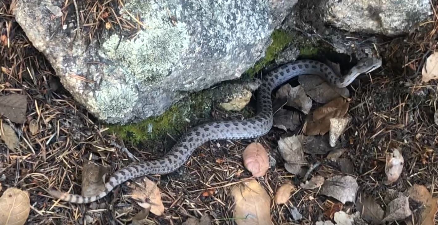
Twin-spotteds are the smallest of the rattlesnake family, inhabiting “sky islands” like this one in southern Arizona. The specimen before me was beautiful, healthy-looking, and in my eyes, cute, albeit fully capable of ruining a careless hiker's day.

I wasn't really worried about border-crossers, either, despite what I'd read about the trail. On one website, a hiker says that a Border Patrol agent near the trailhead at Montezuma Pass, one mile north of the international border, asked if he was packing a gun for the hike. Others report peaceful encounters with migrants on the trail. I didn't take a firearm. I saw a few likely signs of border-crossers: In my experience, most pleasure hikers don't pack canned goods, much less discard empty cans along the trail.
I'd been more worried about heat problems before heading south the day before from Phoenix, where temperatures were soaring to about 115 degrees. But it turns out that for heat-acclimated desert rats, it's a perfect time of year for this hike. Crest Trail starts at a lofty 6,575 feet, and the temperature was only in the 90s, with nice breezes and shade after entering the forest zone. It helped to be sweating profusely, of course. I took three water bottles but only drank from one.
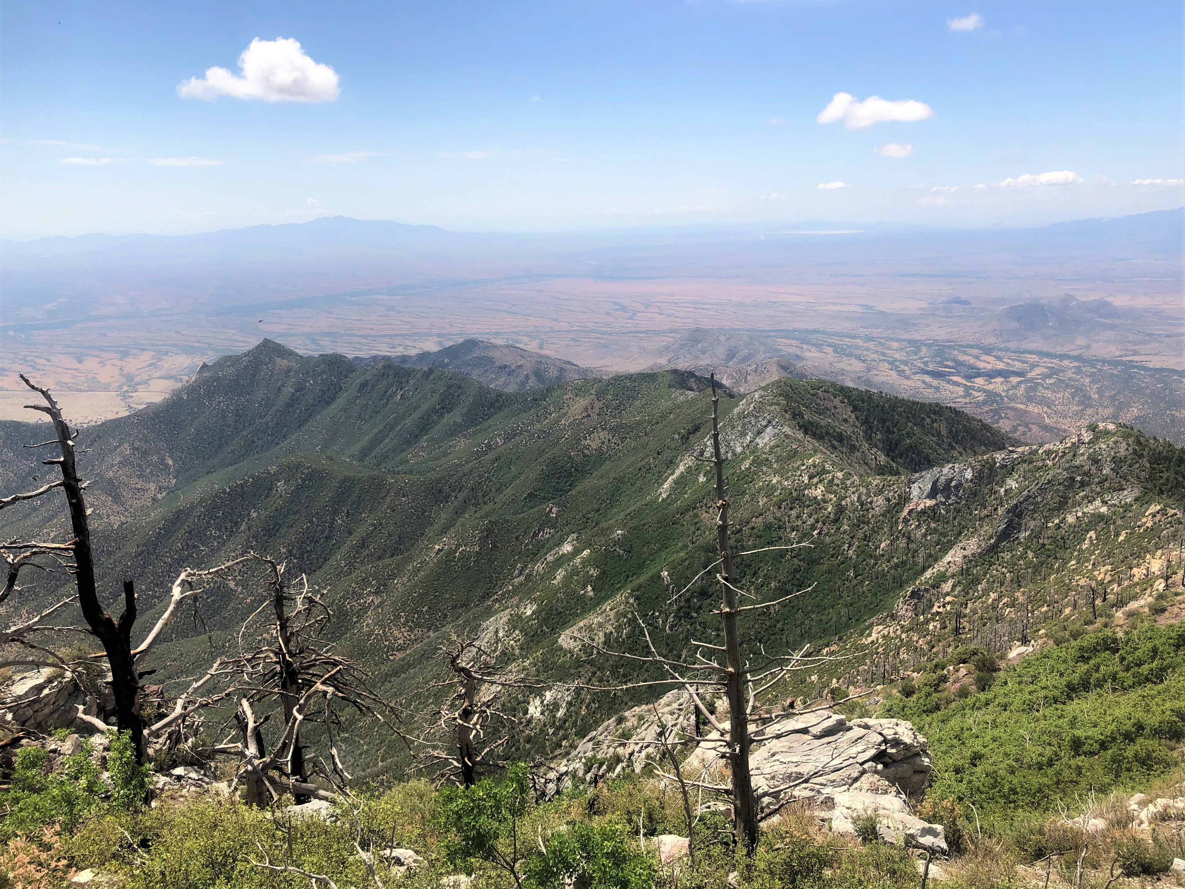
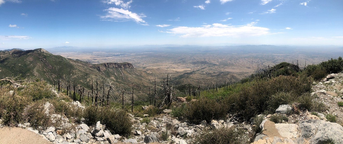
The only downside of the hike was the sad sight of so much burned area, where fire had left short, telephone-pole stumps in place of trees, or no trees, reducing shade significantly in some areas. As the U.S. Forest Service site on the 20,000-acre Miller Peak Wilderness states: “Once cloaked in pine and fir, fires have converted much of this area to predominately oak and grass vegetation with mixed conifer and aspen stands at higher elevations.” Yet, while its past splendor may take decades to return, plenty of trees and spectacular scenery still exist around the peak.
Signs at the trailhead state that it's 5.3 miles to Miller Peak. Fans of Piestewa Peak and Camelback Mountain will love the delicious, seemingly endless, uphill workout as they climb nearly 2,900 vertical feet to the summit. (The Phoenix-area mountains offer gains of 1,200 and 1,300 feet, respectively.)
After a heart-pounding two hours of tough work, the trail rounded a hill to expose building-size blocks of granite and, finally, the summit peak more than a mile away. Thinner air drained my energy in that last mile, but the beauty and peacefulness was a constant and welcome distraction. Sky-island is the perfect name for mountain areas like this or the Chiracahuas to the northeast – far below was a dramatically different, tan-colored Sonoran Desert landscape.
On the summit about three hours after I'd begun, I ate a lunch of tomatoes and a Circle K turkey wrap I'd bought that morning that was now soggy and warm, but still tasty. I took a bunch of snapshots, drank some more water, donned my daypack to head back down, and was then surprised by the sight of a young man walking the last few feet to the summit. We greeted each other, and I asked him if he'd come up from Crest Trail.
“No, I started in Carr Canyon,” he said, explaining that he'd first summited the connected Carr Peak (9,230 feet) a few miles away before trudging up to Miller Peak. He'd hiked about 14 miles so far, he estimated, and would be going more than 10 more on the way back. He was half my age, but the smug feeling that I was some kind of badass for making it to this crag suddenly vanished. This kid was a mountain goat. He and his wife lived in Sierra Vista, he said, and they routinely trekked all over the Huachuca range, leading him to seek out bigger adventures like this.
“Did you see any snakes?” I asked him. “I saw one rattler.”
“I've never seen a rattler up here,” he said. “But I have seen three black bears.”
Gulp.
I'd known bears could be up here, but – three sightings on the same mountain? None of them were close encounters, the hiker continued. We both agreed it would be no fun to surprise a black bear, which can be aggressive.

A desiccated, dead snake on the trail. Is it a Sinaloan milksnake or coral snake? "Red touches yellow, kill a fellow ..."
Ray Stern
I lay somewhat stunned for a few seconds, wondering which bones were broken. My right hand bled lightly from a small cut, but otherwise I was okay. A day later, a silver-dollar-sized bruise emerged on my palm. Considering the lack of other hikers that day, had I been incapacitated, I might not have been discovered until the next day, or longer. The embarrassing incident was yet another reminder of how perilous hiking alone could be. But what the hell – it's a blast.
The winds picked up and thunder rolled every few minutes. I was concerned about being struck by lightning, but not about being doused by rain in the heat. The isolated monsoon was rain-blasting only one side of the mountain, like monsoons often do. The rain cloud descended all the way to the desert floor below me, a few miles to the west. The temperature fell an exquisite 10 degrees. My mood: elated.
I beat the storm back to the car at Montezuma Pass. The whole thing had taken about five and a half hours. As I prepared to leave, a woman in a drenched car drove up from the west on Montezuma Canyon Road and yelled out the window, “I just got hailed on!”
Good times.
If you go: From the east, take State Route 92 to Coronado Memorial Road and head south. Follow that road until it goes west into the Memorial park and becomes Montezuma Canyon Road. Park at Montezuma Pass and look for the well-marked start to Crest Trail just north of the parking lot.
To take the young hiker's route, access Carr Canyon trail from either the Reef Townsite or Ramsey Vista campgrounds on Carr Canyon Road from Sierra Vista. You can also get to Montezuma Pass via a long-but-scenic day drive on border roads all the way from Nogales. Take your AR-15, bear spray, and a suction cup for snake venom – or better yet, just take more water than you think you'll need and throw caution to the monsoon winds.